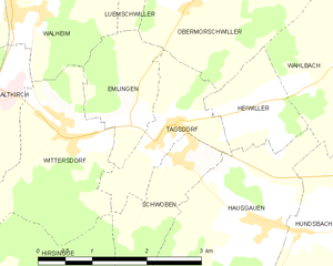
Tagsdorf (Tagsdorf)
- commune in Haut-Rhin, France
Tagsdorf, while not a widely recognized hiking destination, is a small village in the Alsace region of France, near the German border. This area of Alsace is known for its picturesque landscapes, charming vineyards, and rolling hills, making it a lovely location for hiking enthusiasts looking to explore the natural beauty of the region.
Hiking Opportunities in and Around Tagsdorf:
-
Vineyard Trails: The surrounding Alsace region is famous for its vineyards and wine routes. Many trails lead through vineyards, offering beautiful views and opportunities to taste local wines. Look for marked paths that highlight the Alsace Wine Route.
-
Nearby Nature Reserves: Consider exploring nearby nature reserves or parks, such as the Parc Naturel Régional des Ballons des Vosges, which is a bit further away but offers a wealth of hiking trails ranging from easy walks to more challenging hikes.
-
Floral and Fauna Diversity: The Alsace region, including areas surrounding Tagsdorf, is rich in biodiversity. As you hike, keep an eye out for local flora and fauna, including various bird species and wildflowers, particularly in spring and summer.
-
Cultural Landmarks: Incorporate some cultural exploration into your hiking by visiting nearby villages that are rich in history and charm. Many trails may lead you past traditional Alsatian houses and historical sites.
-
Seasonal Considerations: The best times for hiking in this region are spring (April to June) and autumn (September to October) when the weather is mild, and the scenery is vibrant with blooming flowers or autumn leaves.
Tips for Hiking in Tagsdorf:
- Trail Maps: When hiking in less well-known areas, it’s a good idea to have a map or a GPS app to guide you, as trails may not always be well-marked.
- Local Regulations: Always check local regulations regarding hiking, especially when it comes to respecting private property and nature conservation efforts.
- Stay Hydrated and Prepared: Bring enough water and snacks, and wear appropriate footwear, as some trails may have uneven terrain.
Overall, while Tagsdorf may not be a major hiking hub, it provides access to the beautiful natural scenery and charming culture of the Alsace region, making it a rewarding place for a hiking adventure.
- Country:

- Postal Code: 68130
- Coordinates: 47° 37' 17" N, 7° 18' 6" E


- GPS tracks (wikiloc): [Link]
- Area: 2.5 sq km
- Population: 300
- Wikipedia en: wiki(en)
- Wikipedia: wiki(fr)
- Wikidata storage: Wikidata: Q635450
- Wikipedia Commons Category: [Link]
- Freebase ID: [/m/03nsv00]
- Freebase ID: [/m/03nsv00]
- GeoNames ID: Alt: [6441642]
- GeoNames ID: Alt: [6441642]
- SIREN number: [216803338]
- SIREN number: [216803338]
- BnF ID: [15272035s]
- BnF ID: [15272035s]
- INSEE municipality code: 68333
- INSEE municipality code: 68333
Shares border with regions:


Obermorschwiller
- commune in Haut-Rhin, France
Obermorschwiller is a charming village located in the Alsace region of northeastern France, close to the Swiss border. The area is known for its scenic landscapes, rolling hills, and access to the Vosges Mountains, making it a great destination for hiking enthusiasts....
- Country:

- Postal Code: 68130
- Coordinates: 47° 38' 42" N, 7° 18' 39" E


- GPS tracks (wikiloc): [Link]
- Area: 6.05 sq km
- Population: 402
- Web site: [Link]


Hausgauen
- commune in Haut-Rhin, France
Hausgauen, located in the picturesque region of Germany, offers a variety of hiking opportunities suitable for different skill levels. This area is known for its stunning landscapes, including lush forests, rolling hills, and scenic views, making it a great destination for nature enthusiasts....
- Country:

- Postal Code: 68130
- Coordinates: 47° 36' 16" N, 7° 19' 23" E


- GPS tracks (wikiloc): [Link]
- Area: 5.79 sq km
- Population: 398


Heiwiller
- commune in Haut-Rhin, France
Heiwiller is a small village located in the Alsace region of France, known for its picturesque landscapes and proximity to the Vosges mountains. Hiking in and around Heiwiller offers a wonderful opportunity to explore the natural beauty of this area....
- Country:

- Postal Code: 68130
- Coordinates: 47° 37' 26" N, 7° 19' 12" E


- GPS tracks (wikiloc): [Link]
- Area: 2.04 sq km
- Population: 175


Emlingen
- commune in Haut-Rhin, France
Emlingen is a small village located in Germany, and while it might not be a widely recognized hiking destination, the surrounding regions may offer some scenic trails and natural beauty for hiking enthusiasts. Here are some general tips and details about hiking in such areas:...
- Country:

- Postal Code: 68130
- Coordinates: 47° 37' 25" N, 7° 17' 28" E


- GPS tracks (wikiloc): [Link]
- Area: 2.42 sq km
- Population: 278


Schwoben
- commune in Haut-Rhin, France
Schwoben appears to be a lesser-known location and may not have extensive hiking information readily available. However, if you’re considering hiking in the broader region of Schwaben (Swabia) in Germany, I can provide some details....
- Country:

- Postal Code: 68130
- Coordinates: 47° 36' 58" N, 7° 18' 14" E


- GPS tracks (wikiloc): [Link]
- Area: 2.38 sq km
- Population: 226


Wittersdorf
- commune in Haut-Rhin, France
Wittersdorf, a small village located in the Alsace region of France near the border with Switzerland, offers a peaceful and picturesque setting for hiking enthusiasts. The surrounding area is characterized by beautiful landscapes, rolling hills, vineyards, and plenty of natural beauty, making it a delightful spot for both casual walkers and experienced hikers....
- Country:

- Postal Code: 68130
- Coordinates: 47° 37' 18" N, 7° 16' 32" E


- GPS tracks (wikiloc): [Link]
- Area: 4.76 sq km
- Population: 821

