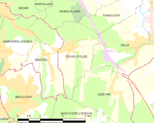
Thiancourt (Thiancourt)
- commune in Territoire de Belfort, France
Thiancourt, a small village in France, is nestled in a picturesque region that offers a variety of hiking opportunities. While it may not be as widely known as some of the larger hiking destinations, it has its charm and scenic landscapes. Here are some key points to consider if you plan to hike in and around Thiancourt:
-
Scenic Trails: The area around Thiancourt features trails that wind through beautiful countryside, forests, and rolling hills. Depending on the season, you can expect to see vibrant flora and potentially some local wildlife.
-
Difficulty Levels: The trails around Thiancourt can vary in difficulty. There are typically suitable options for beginners as well as more challenging routes for experienced hikers. It’s essential to check local maps or guides to choose a trail that matches your ability.
-
Cultural Sites: Hiking in this region can also lead you to historical landmarks and charming villages. Look out for churches, old buildings, and perhaps local markets where you can experience the culture.
-
Weather Conditions: The weather in this part of France can change rapidly, so be sure to check forecasts before heading out. It’s advisable to dress in layers and bring rain gear just in case.
-
Safety and Gear: Always carry enough water, snacks, and a first aid kit. Good hiking boots are crucial for comfort and safety, especially if you're venturing on rugged paths.
-
Local Guides: If you're unfamiliar with the area, consider hiring a local guide who can provide insights into the best trails, hidden gems, and safety tips.
-
Environmental Responsibility: As always, practice Leave No Trace principles; stay on designated trails, pack out what you pack in, and respect local wildlife.
If you’re looking for a peaceful hiking experience amidst natural beauty, Thiancourt is an excellent choice. Make sure to research specific trails and connect with local hikers for the best experience!
- Country:

- Postal Code: 90100
- Coordinates: 47° 31' 24" N, 6° 59' 25" E


- GPS tracks (wikiloc): [Link]
- Area: 2.67 sq km
- Population: 302
- Wikipedia en: wiki(en)
- Wikipedia: wiki(fr)
- Wikidata storage: Wikidata: Q843313
- Wikipedia Commons Category: [Link]
- Freebase ID: [/m/03mhh47]
- Freebase ID: [/m/03mhh47]
- Freebase ID: [/m/03mhh47]
- GeoNames ID: Alt: [6451939]
- GeoNames ID: Alt: [6451939]
- GeoNames ID: Alt: [6451939]
- SIREN number: [219000965]
- SIREN number: [219000965]
- SIREN number: [219000965]
- BnF ID: [152800376]
- BnF ID: [152800376]
- BnF ID: [152800376]
- INSEE municipality code: 90096
- INSEE municipality code: 90096
- INSEE municipality code: 90096
Shares border with regions:


Delle
- commune in Territoire de Belfort, France
Delle, located in the Doubs department of France, is a charming town that serves as a gateway to some wonderful hiking opportunities in the Jura Mountains and surrounding countryside. Here’s what you should know about hiking in this region:...
- Country:

- Postal Code: 90100
- Coordinates: 47° 30' 25" N, 6° 59' 53" E


- GPS tracks (wikiloc): [Link]
- Area: 9.2 sq km
- Population: 5749
- Web site: [Link]


Grandvillars
- commune in Territoire de Belfort, France
Grandvillars, located in the Bourgogne-Franche-Comté region of France, offers a variety of scenic hiking opportunities, particularly for those who appreciate beautiful landscapes and natural surroundings. While the area is less known compared to major French hiking destinations, it still offers potential for enjoyable hikes in relatively serene environments. Here are some key points:...
- Country:

- Postal Code: 90600
- Coordinates: 47° 32' 20" N, 6° 58' 23" E


- GPS tracks (wikiloc): [Link]
- Area: 15.17 sq km
- Population: 2975
- Web site: [Link]

Fêche-l'Église
- commune in Territoire de Belfort, France
Fêche-l'Église is a charming commune located in the Doubs department of the Bourgogne-Franche-Comté region in eastern France. While it may not be as well-known as larger hiking destinations, it offers some beautiful landscapes and opportunities for outdoor enthusiasts looking to explore the serene French countryside....
- Country:

- Postal Code: 90100
- Coordinates: 47° 30' 19" N, 6° 57' 6" E


- GPS tracks (wikiloc): [Link]
- Area: 3.93 sq km
- Population: 792

Joncherey
- commune in Territoire de Belfort, France
Joncherey is a charming village located in the Grand Est region of France, near the borders of Switzerland and Germany. While it might not be as widely known as some other hiking destinations in the area, it offers opportunities for outdoor enthusiasts to explore the natural beauty of the surrounding region....
- Country:

- Postal Code: 90100
- Coordinates: 47° 31' 44" N, 7° 0' 5" E


- GPS tracks (wikiloc): [Link]
- Area: 5.18 sq km
- Population: 1305
- Web site: [Link]

