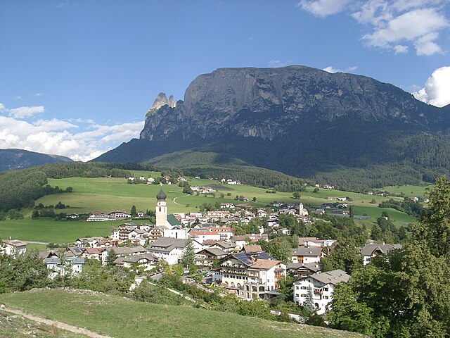
Tiers (Tires)
.svg)
- Italian comune in South Tyrol
 Hiking in Tiers
Tiers (or Tires) is a charming village located in the Dolomites of South Tyrol, Italy, and offers an abundance of hiking opportunities. Here are some highlights about hiking in that area:
Scenic Trails
-
Nature Trails: The surroundings feature numerous well-marked trails suitable for different skill levels, allowing hikers to immerse themselves in stunning alpine scenery, wildflower meadows, and serene forests.
-
Lago di Roda: A lovely hike leads to Lago di Roda, a picturesque lake surrounded by mountains, perfect for a leisurely day trip.
-
Routes to the Rosengarten Group: The Dolomites' iconic Rosengarten massif is a fantastic destination. You can take trails that lead to panoramic viewpoints or even reach the peaks if you are an experienced hiker.
Difficulty Levels
-
Easy Trails: For beginners or families, there are gentle paths in and around Tiers that offer beautiful views and access to local fauna and flora.
-
Moderate to Challenging Trails: Experienced hikers can find routes with steeper inclines, technical sections, and longer distances, including via ferrata options for the adventurous.
Wildlife and Nature
The region is home to diverse wildlife, including chamois, marmots, and various bird species. It’s also an excellent spot for photography, especially during sunrise or sunset when the Dolomites are bathed in golden light.
Local Culture
While hiking, you can experience the unique culture of South Tyrol. Look out for traditional alpine huts (called "Hütten") where you can enjoy local cuisine, such as speck and dumplings, and sample regional wines.
Tips
-
Preparation: Always check the weather and trail conditions before heading out. It's important to wear appropriate footwear and clothing.
-
Hydration and Snacks: Carry enough water and some snacks to keep your energy up during longer hikes.
-
Maps and Guides: Although trails are well-marked, having a detailed map or a hiking app can be beneficial, especially for exploring new routes.
-
Respect Nature: Follow the principles of Leave No Trace to preserve the beauty of the surrounding environment.
Hiking in Tiers provides an incredible opportunity to explore one of the most beautiful regions in the Italian Alps, making it a must-visit for outdoor enthusiasts.
- Country:

- Postal Code: 39050
- Local Dialing Code: 0471
- Licence Plate Code: BZ
- Coordinates: 46° 28' 5" N, 11° 31' 37" E


- GPS tracks (wikiloc): [Link]
- AboveSeaLevel: 1028 м m
- Area: 42.18 sq km
- Population: 987
- Web site: http://www.comune.tires.bz.it
- Wikipedia en: wiki(en)
- Wikipedia: wiki(it)
- Wikidata storage: Wikidata: Q504491
- Wikipedia Commons Gallery: [Link]
- Wikipedia Commons Category: [Link]
- Freebase ID: [/m/0g9k1q]
- GeoNames ID: Alt: [6535936]
- VIAF ID: Alt: [316736002]
- OSM relation ID: [47218]
- GND ID: Alt: [4201457-8]
- ISTAT ID: 021100
- Italian cadastre code: L176
Shares border with regions:


Campitello di Fassa
- Italian comune
Hiking in Campitello di Fassa
Campitello di Fassa, located in the Dolomites in northern Italy, is a picturesque destination for hiking enthusiasts. Surrounded by stunning mountain landscapes, lush forests, and vibrant meadows, it offers a variety of trails suitable for hikers of all skill levels....
- Country:
- Postal Code: 38031
- Local Dialing Code: 0462
- Licence Plate Code: TN
- Coordinates: 46° 28' 36" N, 11° 44' 28" E
- GPS tracks (wikiloc): [Link]
- AboveSeaLevel: 1448 м m
- Area: 25.02 sq km
- Population: 730
- Web site: [Link]


Mazzin
- Italian comune
Hiking in Mazzin
Mazzin, located in the heart of the Dolomites in Italy, is a fantastic destination for hiking enthusiasts. This charming village is part of the Val di Fassa, surrounded by stunning mountain scenery, vibrant meadows, and a rich cultural heritage....
- Country:
- Postal Code: 38030
- Local Dialing Code: 0462
- Licence Plate Code: TN
- Coordinates: 46° 27' 27" N, 11° 42' 2" E
- GPS tracks (wikiloc): [Link]
- AboveSeaLevel: 1395 м m
- Area: 23.63 sq km
- Population: 564
- Web site: [Link]


Kastelruth
- town and comune in Italy
Hiking in Kastelruth
Kastelruth, located in the beautiful Dolomites region of northern Italy, is a fantastic destination for hiking enthusiasts. The area is known for its stunning landscapes, diverse trails, and charming alpine villages. Here are some highlights and tips for hiking in Kastelruth:...
- Country:
- Postal Code: 39040
- Local Dialing Code: 0471
- Licence Plate Code: BZ
- Coordinates: 46° 34' 0" N, 11° 33' 40" E
- GPS tracks (wikiloc): [Link]
- AboveSeaLevel: 2958 м m
- Area: 117.9 sq km
- Population: 6872
- Web site: [Link]


Cornedo all’Isarco (Karneid)
- Italian comune
Hiking in Cornedo all’Isarco (Karneid)
Karneid, located in South Tyrol, Italy, offers beautiful hiking opportunities amidst stunning mountain landscapes. The region is known for its diverse trails that range from easy walks to challenging treks, making it suitable for hikers of all skill levels....
- Country:
- Postal Code: 39053
- Local Dialing Code: 0471
- Licence Plate Code: BZ
- Coordinates: 46° 30' 0" N, 11° 24' 0" E
- GPS tracks (wikiloc): [Link]
- AboveSeaLevel: 510 м m
- Area: 40.61 sq km
- Population: 3391
- Web site: [Link]

Völs am Schlern
- Italian comune
Hiking in Völs am Schlern
Völs am Schlern, nestled in the heart of South Tyrol, Italy, is an excellent destination for hiking enthusiasts. Its picturesque landscape features stunning views of the Sciliar massif and lush green valleys, making it a perfect spot for both novice and experienced hikers....
- Country:
- Postal Code: 39050
- Local Dialing Code: 0471
- Licence Plate Code: BZ
- Coordinates: 46° 31' 0" N, 11° 30' 5" E
- GPS tracks (wikiloc): [Link]
- AboveSeaLevel: 880 м m
- Area: 43.96 sq km
- Population: 3595
- Web site: [Link]


Welschnofen
- Italian comune
Hiking in Welschnofen
Welschnofen, located in the South Tyrol region of Italy, is a beautiful destination for hiking enthusiasts. Nestled in the Dolomites, this charming village offers a range of trails suited for all levels of hikers, from beginners to experienced adventurers. Here are some highlights of hiking in Welschnofen:...
- Country:
- Postal Code: 39056
- Local Dialing Code: 0471
- Licence Plate Code: BZ
- Coordinates: 46° 25' 44" N, 11° 32' 22" E
- GPS tracks (wikiloc): [Link]
- AboveSeaLevel: 1182 м m
- Area: 51.1 sq km
- Population: 1976
- Web site: [Link]