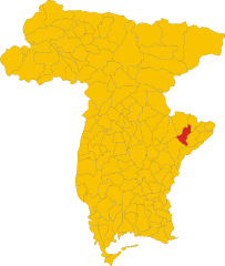
Torreano (Torreano)
.svg)
- Italian comune
 Hiking in Torreano
Torreano, located in the region of Friuli Venezia Giulia in Italy, offers a variety of hiking opportunities amidst beautiful natural landscapes. The area is characterized by rolling hills, vineyards, and charming villages, making it an excellent destination for outdoor enthusiasts.
Hiking Trails
-
Local Trails: There are numerous well-marked trails around Torreano that cater to different skill levels. Most trails are suitable for day hikes and provide stunning views of the surrounding countryside.
-
Collio Wine Region: This area is known for its wineries and vineyards. Several hiking routes allow you to explore the region while enjoying tastings of the local wines.
-
Natural Parks: Nearby natural parks, such as the Prealpi Giulie Natural Park, provide more adventurous hiking opportunities, including trails that lead to higher elevations and offer breathtaking panoramic views.
Tips for Hiking in Torreano
- Best Time to Hike: Spring and early autumn are ideal for hiking, with mild temperatures and blooming nature. Summer can be hot, while winter may bring snow, especially at higher altitudes.
- Local Regulations: Always check local rules regarding hiking and seasonal restrictions. Certain areas may require permits or have specific guidelines.
- What to Bring: Make sure to carry plenty of water, snacks, a first-aid kit, and wear appropriate footwear. A map or a hiking app can be beneficial for navigation.
- Guided Tours: Consider joining local guided hiking tours if you're unfamiliar with the area. They can provide insights into the local flora, fauna, and history.
Cultural Experience
While hiking, take the time to enjoy the local culture. Torreano is known for its beautiful architecture, including typical Friulian houses and churches. Stopping at small villages or local restaurants can also provide a taste of the local cuisine.
Whether you're a seasoned hiker or just looking for a leisurely stroll, Torreano has something to offer everyone. Enjoy your adventures in this picturesque part of Italy!
- Country:

- Postal Code: 33040
- Local Dialing Code: 0432
- Licence Plate Code: UD
- Coordinates: 46° 8' 0" N, 13° 26' 0" E


- GPS tracks (wikiloc): [Link]
- AboveSeaLevel: 189 м m
- Area: 34.99 sq km
- Population: 2129
- Web site: http://www.torreano.net/
- Wikipedia en: wiki(en)
- Wikipedia: wiki(it)
- Wikidata storage: Wikidata: Q53382
- Wikipedia Commons Category: [Link]
- Freebase ID: [/m/0gkbmf]
- GeoNames ID: Alt: [6539698]
- VIAF ID: Alt: [244354797]
- OSM relation ID: [79274]
- MusicBrainz area ID: [94ad0ba3-42f4-4dd2-a995-573a625d1fd0]
- UN/LOCODE: [ITTOE]
- ISTAT ID: 030122
- Italian cadastre code: L246
Shares border with regions:
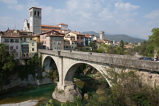

Cividale del Friuli
- Italian comune
Hiking in Cividale del Friuli
Cividale del Friuli, located in the Friuli Venezia Giulia region of northeastern Italy, is not only a town rich in history and culture but also a great destination for hiking enthusiasts. The surrounding landscapes are diverse, featuring rolling hills, vineyards, and views of the nearby Julian Alps. Here are some of the highlights of hiking in this area:...
- Country:
- Postal Code: 33043
- Local Dialing Code: 0432
- Licence Plate Code: UD
- Coordinates: 46° 5' 26" N, 13° 26' 6" E
- GPS tracks (wikiloc): [Link]
- AboveSeaLevel: 135 м m
- Area: 50 sq km
- Population: 11292
- Web site: [Link]


Faedis
- Italian comune
Hiking in Faedis
Faedis, a picturesque village located in the Friuli Venezia Giulia region of northeastern Italy, offers a variety of hiking opportunities amidst stunning landscapes. Here are some highlights of hiking in and around Faedis:...
- Country:
- Postal Code: 33040
- Local Dialing Code: 0432
- Licence Plate Code: UD
- Coordinates: 46° 9' 0" N, 13° 21' 0" E
- GPS tracks (wikiloc): [Link]
- AboveSeaLevel: 176 м m
- Area: 46.78 sq km
- Population: 2871
- Web site: [Link]


Moimacco
- Italian comune
Hiking in Moimacco
Moimacco is a small town located in the Friuli-Venezia Giulia region of northeastern Italy. It may not be as widely known as some other hiking destinations, but the surrounding area offers beautiful landscapes and opportunities for outdoor activities. Here’s what you should know about hiking in and around Moimacco:...
- Country:
- Postal Code: 33040
- Local Dialing Code: 0432
- Licence Plate Code: UD
- Coordinates: 46° 6' 0" N, 13° 23' 0" E
- GPS tracks (wikiloc): [Link]
- AboveSeaLevel: 121 м m
- Area: 11.77 sq km
- Population: 1678
- Web site: [Link]
Pulfero
- Italian comune
Hiking in Pulfero
Pulfero, located in the Friuli Venezia Giulia region of Italy, is a beautiful destination for hikers. Known for its stunning natural landscapes, the area offers a variety of trails that cater to different skill levels, from easy walks to challenging hikes....
- Country:
- Postal Code: 33046
- Local Dialing Code: 0432
- Licence Plate Code: UD
- Coordinates: 46° 10' 24" N, 13° 29' 4" E
- GPS tracks (wikiloc): [Link]
- AboveSeaLevel: 184 м m
- Area: 48.68 sq km
- Population: 923
- Web site: [Link]

San Pietro al Natisone
- Italian comune
Hiking in San Pietro al Natisone
San Pietro al Natisone, located in the northeastern part of Italy, near the border with Slovenia, is a beautiful area for hiking enthusiasts. The region features stunning natural landscapes, including rolling hills, dense forests, and the Natisone River. Here are some key highlights regarding hiking in this area:...
- Country:
- Postal Code: 33049
- Local Dialing Code: 0432
- Licence Plate Code: UD
- Coordinates: 46° 7' 48" N, 13° 29' 14" E
- GPS tracks (wikiloc): [Link]
- AboveSeaLevel: 175 м m
- Area: 23.97 sq km
- Population: 2134
- Web site: [Link]