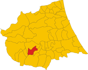
Tossicia (Tossicia)
- Italian comune
Tossicia is a charming town located in the Abruzzo region of Italy, surrounded by stunning landscapes and natural beauty, making it an appealing destination for hiking enthusiasts. The area features a variety of hiking trails suitable for different skill levels, allowing you to explore the picturesque mountains, forests, and valleys.
Suggested Hiking Trails
-
Gran Sasso National Park:
- Located nearby, this park offers numerous trails with breathtaking views of the Gran Sasso mountain range. The paths vary in difficulty, ranging from easy walks to challenging scrambles.
-
Monti della Laga:
- This mountain range is part of the broader Gran Sasso e Monti della Laga National Park. The hiking trails here allow you to explore beautiful landscapes, with options to trek through dense forests and along panoramic ridges.
-
Local Trails:
- The area around Tossicia has several marked trails that lead to scenic spots, including old monasteries, waterfalls, and viewpoints. Many trails start from the town or nearby villages.
Flora and Fauna
Hiking in Tossicia provides opportunities to see a rich diversity of flora and fauna, including various species of wildflowers, trees, and animals such as deer, foxes, and many bird species.
Best Time to Hike
The ideal time for hiking in Tossicia is during the spring (April to June) and fall (September to October) when the weather is mild, and the scenery is particularly beautiful. Summer can be quite hot, especially in lower elevations, while winter may bring snow in the mountains, making certain trails inaccessible.
Preparation Tips
- Footwear: Wear sturdy hiking boots for comfort and support on varied terrain.
- Gear: Bring adequate gear, including water, snacks, a map or GPS, and weather-appropriate clothing.
- Local Guidance: Consider hiring a local guide if you are unfamiliar with the area or want to learn more about the region's natural and historical significance.
Overall, hiking in Tossicia provides a wonderful opportunity to connect with nature while enjoying the beauty of Abruzzo’s landscapes. Happy hiking!
- Country:

- Postal Code: 64049
- Local Dialing Code: 0861
- Licence Plate Code: TE
- Coordinates: 42° 33' 0" N, 13° 39' 0" E


- GPS tracks (wikiloc): [Link]
- AboveSeaLevel: 409 м m
- Area: 27.14 sq km
- Population: 1333
- Web site: http://www.comune.tossicia.te.it/
- Wikipedia en: wiki(en)
- Wikipedia: wiki(it)
- Wikidata storage: Wikidata: Q51471
- Wikipedia Commons Category: [Link]
- Freebase ID: [/m/0fs4dx]
- GeoNames ID: Alt: [6537462]
- VIAF ID: Alt: [132324553]
- OSM relation ID: [42070]
- ISTAT ID: 067045
- Italian cadastre code: L314
Shares border with regions:


Colledara
- Italian comune
Colledara is a picturesque town located in the Abruzzo region of Italy, known for its stunning landscapes and outdoor activities, particularly hiking. The area is characterized by rolling hills, beautiful valleys, and proximity to the Gran Sasso and Monti della Laga National Park, which makes it an excellent destination for hikers of all levels....
- Country:

- Postal Code: 64042
- Local Dialing Code: 0861
- Licence Plate Code: TE
- Coordinates: 42° 32' 0" N, 13° 41' 0" E


- GPS tracks (wikiloc): [Link]
- AboveSeaLevel: 430 м m
- Area: 18.01 sq km
- Population: 2151
- Web site: [Link]


Fano Adriano
- Italian comune
Fano Adriano, a small town in the Abruzzo region of Italy, offers a picturesque setting for hikers seeking to explore the natural beauty of the area. Nestled in the Gran Sasso and Monti della Laga National Park, this region boasts a variety of hiking trails suited for different skill levels, from leisurely walks to more challenging treks....
- Country:

- Postal Code: 64044
- Local Dialing Code: 0861
- Licence Plate Code: TE
- Coordinates: 42° 33' 14" N, 13° 32' 12" E


- GPS tracks (wikiloc): [Link]
- AboveSeaLevel: 745 м m
- Area: 35.77 sq km
- Population: 278
- Web site: [Link]


Isola del Gran Sasso d'Italia
- Italian comune
 Hiking in Isola del Gran Sasso d'Italia
Isola del Gran Sasso d'Italia is a beautiful area in the Abruzzo region of Italy, known for its stunning mountainous landscapes, rich biodiversity, and a variety of hiking trails suitable for different skill levels. It’s part of the Gran Sasso e Monti della Laga National Park, the largest protected area in the Apennines....
- Country:

- Postal Code: 64045
- Local Dialing Code: 0861
- Licence Plate Code: TE
- Coordinates: 42° 30' 27" N, 13° 39' 28" E


- GPS tracks (wikiloc): [Link]
- AboveSeaLevel: 498 м m
- Area: 84.05 sq km
- Population: 4684
- Web site: [Link]
Montorio al Vomano
- Italian comune
Montorio al Vomano is a charming town located in the Abruzzo region of Italy, surrounded by beautiful landscapes that make it an excellent destination for hiking enthusiasts. The area features a mix of mountainous terrain, lush forests, and scenic views, making it ideal for both casual hikers and more experienced trekkers....
- Country:

- Postal Code: 64046
- Local Dialing Code: 0861
- Licence Plate Code: TE
- Coordinates: 42° 35' 0" N, 13° 38' 0" E


- GPS tracks (wikiloc): [Link]
- AboveSeaLevel: 262 м m
- Area: 53.57 sq km
- Population: 8013
- Web site: [Link]
