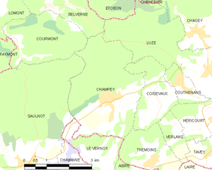
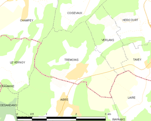
Trémoins (Trémoins)
- commune in Haute-Saône, France
Trémoins is a small village located in the Bourgogne-Franche-Comté region of France. While it might not be as widely known as other hiking destinations, the surrounding countryside offers opportunities for outdoor activities including hiking.
Hiking in Trémoins and Surrounding Areas
-
Landscape and Scenery: The region around Trémoins features beautiful rural landscapes, including fields, woodlands, and rolling hills. Hikers can enjoy the charm of the countryside and the serene atmosphere that comes with it.
-
Trails: There may not be specific marked trails directly in Trémoins, but nearby areas often have walking routes that can be accessed. You might consider exploring trails that lead to nearby towns or natural attractions in the region, such as parts of the Jura Mountains or the Doubs area.
-
Local Wildlife: The area can be rich in wildlife, offering opportunities to observe various bird species and small mammals. Keep your eyes peeled for unique flora as well!
-
Cultural Sites: Many hiking routes in the region can also lead you to historical and cultural sites, such as quaint villages, old churches, and traditional farms. It can be a great way to combine physical activity with cultural exploration.
-
Best Season to Hike: Spring and fall are ideal for hiking in this region, as temperatures are mild and the scenery is particularly beautiful with blooming flowers or vibrant foliage.
Preparation Tips
- Footwear: Wear sturdy hiking boots to navigate potentially uneven terrain.
- Hydration: Bring enough water, particularly if heading out for a longer hike.
- Maps: Consider bringing a detailed map or using a GPS app to navigate the trails.
- Weather: Check the weather forecast before heading out, as conditions can change rapidly.
If you're keen on experiencing the local culture alongside your hiking adventures, consider stopping by local markets or tasting regional foods to enhance your hiking trip in and around Trémoins. Enjoy your hike!
- Country:

- Postal Code: 70400
- Coordinates: 47° 33' 42" N, 6° 42' 17" E


- GPS tracks (wikiloc): [Link]
- Area: 4.03 sq km
- Population: 377
- Web site: http://www.tremoins.com
- Wikipedia en: wiki(en)
- Wikipedia: wiki(fr)
- Wikidata storage: Wikidata: Q250666
- Wikipedia Commons Category: [Link]
- Freebase ID: [/m/03nvs_2]
- GeoNames ID: Alt: [6442128]
- SIREN number: [217005065]
- BnF ID: [15272898w]
- INSEE municipality code: 70506
Shares border with regions:


Aibre
- commune in Doubs, France
It seems there may be a typo or misunderstanding regarding "Aibre," as there isn’t a well-known hiking location by that name in commonly referenced hiking guides or maps. However, if you're referring to a particular area or if it’s a local name, I’d be happy to help with general hiking advice or information about popular hiking destinations in your region....
- Country:

- Postal Code: 25750
- Coordinates: 47° 33' 4" N, 6° 41' 48" E


- GPS tracks (wikiloc): [Link]
- Area: 4.5 sq km
- Population: 480


Verlans
- commune in Haute-Saône, France
Hiking in Verlaine, or the surrounding regions depending on the specific area you are referencing, can be a wonderful outdoor activity. However, it's important to note that Verlaine itself, in Belgium, is a small village, and may not have extensive hiking trails....
- Country:

- Postal Code: 70400
- Coordinates: 47° 34' 18" N, 6° 43' 15" E


- GPS tracks (wikiloc): [Link]
- Area: 1.64 sq km
- Population: 193
- Web site: [Link]


Laire
- commune in Doubs, France
Laire is not widely recognized as a specific hiking destination, so it's possible that you meant a different location—or that Laire may be a less-known area with trails. If you are referring to a region or national park, like in the French Alps, Pyrenees, or anywhere else specifically, please clarify, and I will be happy to provide information on that area....
- Country:

- Postal Code: 25550
- Coordinates: 47° 33' 2" N, 6° 43' 58" E


- GPS tracks (wikiloc): [Link]
- Area: 3.17 sq km
- Population: 395


Le Vernoy
- commune in Doubs, France
Le Vernoy is a lesser-known hiking area located in the beautiful surroundings of the French Alps. While specific trails may vary, the region generally offers a variety of hiking opportunities suitable for different skill levels, from beginners to experienced hikers. Here are some key aspects to consider if you plan to hike in Le Vernoy:...
- Country:

- Postal Code: 25750
- Coordinates: 47° 33' 35" N, 6° 40' 32" E


- GPS tracks (wikiloc): [Link]
- Area: 3.3 sq km
- Population: 171


Champey
- commune in Haute-Saône, France
Hiking in Champey, also known as Champasak, is a wonderful experience, particularly for those looking to explore the natural beauty and cultural heritage of southern Laos. Here are some key points to consider:...
- Country:

- Postal Code: 70400
- Coordinates: 47° 35' 5" N, 6° 40' 50" E


- GPS tracks (wikiloc): [Link]
- Area: 11.3 sq km
- Population: 874


Coisevaux
- commune in Haute-Saône, France
Coisevaux, located in the scenic Jura region of France, offers an excellent environment for hiking enthusiasts. The Jura mountains are known for their diverse landscapes, which include lush forests, rolling hills, and stunning viewpoints overlooking valleys....
- Country:

- Postal Code: 70400
- Coordinates: 47° 34' 47" N, 6° 42' 22" E


- GPS tracks (wikiloc): [Link]
- Area: 4.18 sq km
- Population: 341

