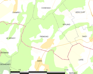
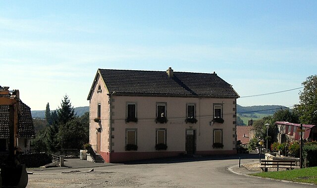
Le Vernoy (Le Vernoy)

- commune in Doubs, France
 Hiking in Le Vernoy
Le Vernoy is a lesser-known hiking area located in the beautiful surroundings of the French Alps. While specific trails may vary, the region generally offers a variety of hiking opportunities suitable for different skill levels, from beginners to experienced hikers. Here are some key aspects to consider if you plan to hike in Le Vernoy:
Scenic Trails
- Natural Beauty: The area features stunning alpine landscapes, including lush forests, mountain meadows, and panoramic views of nearby peaks.
- Wildlife: Hikers may encounter a variety of wildlife, including birds and possibly small mammals, depending on the season.
Popular Hikes
- Circuit Trails: Many trails are circular, allowing hikers to explore different facets of the area while making a loop back to their starting point.
- Elevation Changes: Prepare for varying elevation changes which can lead to different levels of difficulty.
Accessibility
- Trailheads: Access points can typically be found near parking areas or public transport stops.
- Seasonal Considerations: Depending on the time of year, be aware of snow cover or trail conditions that could affect accessibility.
Tips for Hiking in Le Vernoy
- Prepare for Weather: The weather can change rapidly in the mountains, so dress in layers and be prepared for rain or cold weather.
- Footwear: Sturdy hiking boots are essential to navigate rocky and uneven terrain.
- Navigation: While some trails may be well-marked, it’s always a good idea to carry a map or GPS device.
- Hydration and Snacks: Bring plenty of water and snacks to keep your energy up while on the trail.
Local Regulations
- Leave No Trace: Follow principles to minimize your impact on the environment.
- Wildlife Guidelines: Keep a safe distance from wildlife and be aware of local guidelines regarding interactions.
Exploring Le Vernoy offers a fantastic way to experience the natural beauty of the Alps while enjoying outdoor activity. Always check local resources or visitor centers for up-to-date information on trails and conditions before heading out.
- Country:

- Postal Code: 25750
- Coordinates: 47° 33' 35" N, 6° 40' 32" E


- GPS tracks (wikiloc): [Link]
- Area: 3.3 sq km
- Population: 171
- Wikipedia en: wiki(en)
- Wikipedia: wiki(fr)
- Wikidata storage: Wikidata: Q731929
- Wikipedia Commons Category: [Link]
- Freebase ID: [/m/03mhf49]
- GeoNames ID: Alt: [6455733]
- SIREN number: [212506083]
- BnF ID: [152528347]
- INSEE municipality code: 25608
Shares border with regions:

Trémoins
- commune in Haute-Saône, France
Hiking in Trémoins
Trémoins is a small village located in the Bourgogne-Franche-Comté region of France. While it might not be as widely known as other hiking destinations, the surrounding countryside offers opportunities for outdoor activities including hiking....
- Country:
- Postal Code: 70400
- Coordinates: 47° 33' 42" N, 6° 42' 17" E
- GPS tracks (wikiloc): [Link]
- Area: 4.03 sq km
- Population: 377
- Web site: [Link]


Aibre
- commune in Doubs, France
Hiking in Aibre
It seems there may be a typo or misunderstanding regarding "Aibre," as there isn’t a well-known hiking location by that name in commonly referenced hiking guides or maps. However, if you're referring to a particular area or if it’s a local name, I’d be happy to help with general hiking advice or information about popular hiking destinations in your region....
- Country:
- Postal Code: 25750
- Coordinates: 47° 33' 4" N, 6° 41' 48" E
- GPS tracks (wikiloc): [Link]
- Area: 4.5 sq km
- Population: 480

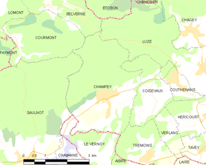
Champey
- commune in Haute-Saône, France
Hiking in Champey
Hiking in Champey, also known as Champasak, is a wonderful experience, particularly for those looking to explore the natural beauty and cultural heritage of southern Laos. Here are some key points to consider:...
- Country:
- Postal Code: 70400
- Coordinates: 47° 35' 5" N, 6° 40' 50" E
- GPS tracks (wikiloc): [Link]
- Area: 11.3 sq km
- Population: 874

Chavanne
- commune in Haute-Saône, France
Hiking in Chavanne
Chavanne, located in the Swiss Alps, is a beautiful destination for hiking enthusiasts. The area is known for its stunning natural scenery, diverse trails, and breathtaking panoramic views. Here are some key points to consider if you're planning a hiking trip to Chavanne:...
- Country:
- Postal Code: 70400
- Coordinates: 47° 33' 28" N, 6° 39' 29" E
- GPS tracks (wikiloc): [Link]
- AboveSeaLevel: 420 м m
- Area: 2.32 sq km
- Population: 234


Désandans
- commune in Doubs, France
Hiking in Désandans
Désandans is a small commune located in the Doubs department in the Bourgogne-Franche-Comté region of eastern France. While it may not be as widely known as some larger hiking destinations, there are still opportunities for outdoor enthusiasts to explore the scenic beauty of the area....
- Country:
- Postal Code: 25750
- Coordinates: 47° 31' 59" N, 6° 40' 38" E
- GPS tracks (wikiloc): [Link]
- Area: 5.47 sq km
- Population: 720


Saulnot
- commune in Haute-Saône, France
Hiking in Saulnot
Saulnot is a quaint village located in the Bourgogne-Franche-Comté region of France, surrounded by beautiful natural landscapes that make it an appealing destination for hiking enthusiasts. The area offers a mix of scenic trails that cater to various skill levels, from leisurely walks to more challenging hikes....
- Country:
- Postal Code: 70400
- Coordinates: 47° 33' 45" N, 6° 38' 0" E
- GPS tracks (wikiloc): [Link]
- Area: 26.73 sq km
- Population: 748
- Web site: [Link]