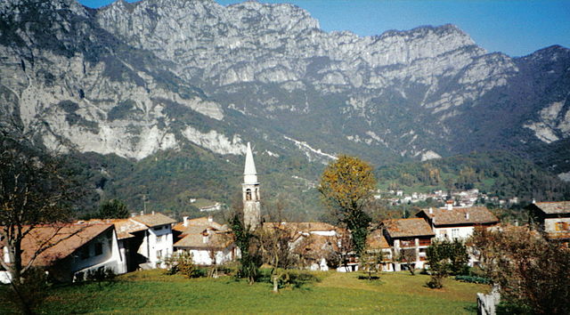
Tramonti di Sopra (Tramonti di Sopra)
.svg)
- Italian comune
 Hiking in Tramonti di Sopra
Tramonti di Sopra is a beautiful area located in the Friuli Venezia Giulia region of Italy. It's known for its stunning landscapes, lush green valleys, and majestic mountains, making it a great destination for hiking enthusiasts.
Hiking Highlights in Tramonti di Sopra:
-
Scenic Trails: The area offers a variety of hiking trails that cater to different skill levels, from easy walks suitable for families to more challenging routes for experienced hikers. These trails often provide breathtaking views of the surrounding mountains and valleys.
-
Natural Parks: Tramonti di Sopra is close to several natural parks, such as the Dolomiti Friulane Natural Park. This park features rugged terrain, diverse flora and fauna, and opportunities for wildlife spotting.
-
Historical Significance: While hiking, you may come across historical sites, such as old villages or remnants of ancient fortifications. Exploring these can add a cultural dimension to your hike.
-
Waterfalls and Lakes: The region is home to beautiful waterfalls and alpine lakes, which can often be reached by hiking trails. These spots make for perfect rest stops or picnic areas.
-
Local Flora and Fauna: The region’s diverse ecosystems support a wide variety of plant and animal species. Whether you're a nature lover or a photographer, keep your eyes peeled for unique wildlife and vibrant plant life along the trails.
Tips for Hiking in Tramonti di Sopra:
-
Best Time to Visit: The best hiking season typically runs from late spring to early fall (May to September). Summer offers excellent weather, while spring can provide beautiful wildflowers.
-
Trail Maps: It’s advisable to carry a detailed map of the hiking trails or use a reliable GPS app, as some paths may be less marked.
-
Gear Up: Wear sturdy hiking boots and dress in layers to adapt to changing weather conditions. Always carry sufficient water and snacks.
-
Local Guidance: If you're unfamiliar with the area, consider hiring a local guide who can provide insights into the best trails and hidden gems.
-
Respect Nature: Always follow the Leave No Trace principles to preserve the beauty of this natural area.
Whether you're seeking adventure, tranquility, or the chance to explore nature, Tramonti di Sopra offers a remarkable hiking experience.
- Country:

- Postal Code: 33090
- Local Dialing Code: 0427
- Licence Plate Code: PN
- Coordinates: 46° 19' 0" N, 12° 48' 0" E


- GPS tracks (wikiloc): [Link]
- AboveSeaLevel: 420 м m
- Area: 125.15 sq km
- Population: 301
- Web site: http://www.comune.tramonti-di-sopra.pn.it
- Wikipedia en: wiki(en)
- Wikipedia: wiki(it)
- Wikidata storage: Wikidata: Q53199
- Wikipedia Commons Category: [Link]
- Freebase ID: [/m/0gqzqv]
- GeoNames ID: Alt: [6539334]
- VIAF ID: Alt: [243203973]
- OSM relation ID: [79126]
- ISTAT ID: 093045
- Italian cadastre code: L324
Shares border with regions:


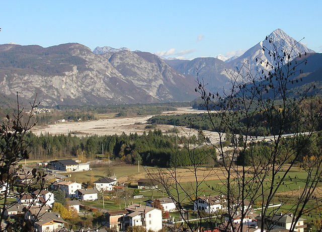
Claut
- Italian comune
Hiking in Claut
Claut is a picturesque village located in the Friuli Venezia Giulia region of northeastern Italy. Nestled in the heart of the Carnic Alps, it offers excellent hiking opportunities for both beginners and experienced hikers. Here are some aspects to consider when hiking in Claut:...
- Country:
- Postal Code: 33080
- Local Dialing Code: 0427
- Licence Plate Code: PN
- Coordinates: 46° 16' 0" N, 12° 31' 0" E
- GPS tracks (wikiloc): [Link]
- AboveSeaLevel: 613 м m
- Area: 165.91 sq km
- Population: 946
- Web site: [Link]

Frisanco
- Italian comune
Hiking in Frisanco
Frisanco, located in the province of Pordenone in the Friuli Venezia Giulia region of Italy, offers a delightful experience for hikers of all levels. The area is surrounded by the beautiful Friulian Dolomites, providing stunning landscapes, varying terrains, and rich natural biodiversity....
- Country:
- Postal Code: 33080
- Local Dialing Code: 0427
- Licence Plate Code: PN
- Coordinates: 46° 13' 0" N, 12° 44' 0" E
- GPS tracks (wikiloc): [Link]
- AboveSeaLevel: 500 м m
- Area: 60.99 sq km
- Population: 600
- Web site: [Link]
Meduno
- Italian comune
Hiking in Meduno
Meduno is a small town located in the Friuli Venezia Giulia region of northeastern Italy, surrounded by beautiful natural landscapes that are great for hiking enthusiasts. The area features diverse terrains, including rolling hills, forests, and stunning views of the surrounding mountains, particularly the nearby Dolomites....
- Country:
- Postal Code: 33092
- Local Dialing Code: 0427
- Licence Plate Code: PN
- Coordinates: 46° 13' 0" N, 12° 48' 0" E
- GPS tracks (wikiloc): [Link]
- AboveSeaLevel: 313 м m
- Area: 31.59 sq km
- Population: 1541
- Web site: [Link]


Tramonti di Sotto
- Italian comune
Hiking in Tramonti di Sotto
Tramonti di Sotto is a picturesque village located in the Friuli Venezia Giulia region of northeastern Italy, nestled within the Julian Alps. The area is known for its natural beauty, offering a range of hiking opportunities suitable for various skill levels. Here are some highlights of hiking in the region:...
- Country:
- Postal Code: 33090
- Local Dialing Code: 0427
- Licence Plate Code: PN
- Coordinates: 46° 17' 0" N, 12° 48' 0" E
- GPS tracks (wikiloc): [Link]
- AboveSeaLevel: 366 м m
- Area: 85.55 sq km
- Population: 367
- Web site: [Link]


Forni di Sotto
- Italian comune
Hiking in Forni di Sotto
Forni di Sotto is a beautiful gem in the Friuli Venezia Giulia region of northern Italy, nestled in the Carnic Alps. This area is known for its stunning natural landscapes, rich biodiversity, and a variety of hiking trails suitable for all levels of experience. Here are some highlights about hiking in Forni di Sotto:...
- Country:
- Postal Code: 33020
- Local Dialing Code: 0433
- Licence Plate Code: UD
- Coordinates: 46° 24' 0" N, 12° 40' 0" E
- GPS tracks (wikiloc): [Link]
- AboveSeaLevel: 777 м m
- Area: 93.6 sq km
- Population: 583
- Web site: [Link]

Socchieve
- Italian comune
Hiking in Socchieve
Socchieve, a picturesque area in the Julian Alps of Italy, is known for its stunning natural landscapes and diverse hiking trails suitable for a variety of skill levels. Here’s what you can expect when hiking in Socchieve:...
- Country:
- Postal Code: 33020
- Local Dialing Code: 0433
- Licence Plate Code: UD
- Coordinates: 46° 23' 48" N, 12° 50' 53" E
- GPS tracks (wikiloc): [Link]
- AboveSeaLevel: 480 м m
- Area: 66.12 sq km
- Population: 896
- Web site: [Link]