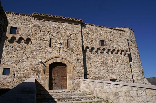
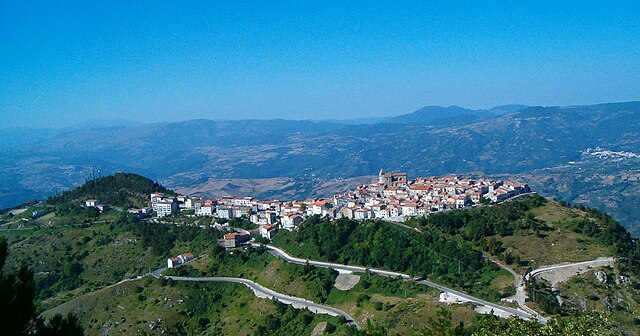
Trivento (Trivento)
.svg)
- Italian comune
 Hiking in Trivento
Trivento is a charming town located in the Molise region of Italy, known for its beautiful landscapes and rich history. Hiking in and around Trivento can offer a unique experience, featuring a mix of natural beauty, cultural heritage, and a chance to explore the surrounding countryside.
Key Hiking Areas and Trails:
-
Local Trails: The area surrounding Trivento has a network of local trails that often take hikers through vineyards, olive groves, and picturesque landscapes. These are usually well-marked and can vary in difficulty.
-
Parco Nazionale di Abruzzo: While a bit further away, this national park, about an hour’s drive from Trivento, offers stunning hiking opportunities. You can explore rugged mountains, pristine rivers, and diverse wildlife.
-
Monti della Meta: This mountain range is not far from Trivento and features several trails with breathtaking views. The trails vary in difficulty, catering to different levels of hikers.
-
Historical Routes: There are many paths that lead to ancient ruins and historical sites in the region. Exploring these routes provides insights into the history and culture of Molise.
Tips for Hiking in Trivento:
-
Weather Considerations: Check the weather before you head out, as conditions can change rapidly in mountainous areas. Spring and fall are typically more pleasant for hiking.
-
Appropriate Gear: Wear sturdy hiking boots, and consider bringing trekking poles if you’re tackling more challenging trails. Always have a backpack with essentials like water, snacks, a first-aid kit, and a map or GPS device.
-
Local Resources: Consider stopping by local tourism offices for maps, trail recommendations, and updates on trail conditions.
-
Respect Nature: Practice Leave No Trace principles to preserve the natural beauty of the area. This includes packing out all your trash and staying on marked trails.
-
Wildlife Awareness: Be aware of the local wildlife, and learn about any precautions you may need to take.
Hiking in Trivento is an enriching experience, allowing you to immerse yourself in the beautiful landscapes and local culture of this lesser-known region of Italy. Enjoy your adventure!
- Country:

- Postal Code: 86029
- Local Dialing Code: 0874
- Licence Plate Code: CB
- Coordinates: 41° 46' 0" N, 14° 33' 0" E


- GPS tracks (wikiloc): [Link]
- AboveSeaLevel: 599 м m
- Area: 73 sq km
- Population: 4663
- Web site: http://www.comune.trivento.cb.it
- Wikipedia en: wiki(en)
- Wikipedia: wiki(it)
- Wikidata storage: Wikidata: Q278361
- Wikipedia Commons Category: [Link]
- Freebase ID: [/m/0gnq0r]
- GeoNames ID: Alt: [6538917]
- VIAF ID: Alt: [236553259]
- OSM relation ID: [41511]
- GND ID: Alt: [4515091-6]
- MusicBrainz area ID: [5b69016b-0ad3-42f8-86a9-880f40e0d955]
- UN/LOCODE: [ITTVT]
- Digital Atlas of the Roman Empire ID: [22939]
- Google Maps Customer ID: [16564408804896701927]
- ISTAT ID: 070081
- Italian cadastre code: L435
Shares border with regions:
Lucito
- Italian comune
Hiking in Lucito
Lucito is a small town located in the Molise region of Italy. While it may not be as well-known for hiking as other Italian destinations, the surrounding landscapes offer beautiful opportunities for outdoor activities, including hiking....
- Country:
- Postal Code: 86030
- Local Dialing Code: 0874
- Licence Plate Code: CB
- Coordinates: 41° 44' 0" N, 14° 41' 0" E
- GPS tracks (wikiloc): [Link]
- AboveSeaLevel: 480 м m
- Area: 31.56 sq km
- Population: 666
- Web site: [Link]


Castelmauro
- Italian comune
Hiking in Castelmauro
Castelmauro is a picturesque village located in the Molise region of Italy. Nestled in the Apennine Mountains, it offers beautiful landscapes and a serene hiking experience. Here are some highlights regarding hiking in and around Castelmauro:...
- Country:
- Postal Code: 86031
- Local Dialing Code: 0874
- Licence Plate Code: CB
- Coordinates: 41° 50' 0" N, 14° 43' 0" E
- GPS tracks (wikiloc): [Link]
- AboveSeaLevel: 692 м m
- Area: 43.62 sq km
- Population: 1446
- Web site: [Link]

Civitacampomarano
- Italian comune
Hiking in Civitacampomarano
Civitacampomarano is a charming village located in the Molise region of Italy, known for its stunning landscapes, rich history, and traditional architecture. Hiking in and around Civitacampomarano provides a unique opportunity to explore the natural beauty and cultural heritage of this lesser-known area of Italy....
- Country:
- Postal Code: 86030
- Local Dialing Code: 0874
- Licence Plate Code: CB
- Coordinates: 41° 47' 0" N, 14° 41' 0" E
- GPS tracks (wikiloc): [Link]
- AboveSeaLevel: 520 м m
- Area: 38.89 sq km
- Population: 385
- Web site: [Link]
Roccavivara
- Italian comune
Hiking in Roccavivara
Roccavivara is a small town located in the Molise region of Italy, offering a range of hiking opportunities in a beautiful landscape characterized by rolling hills, forests, and historical sites. Here are some key points for hiking in and around Roccavivara:...
- Country:
- Postal Code: 86020
- Local Dialing Code: 0874
- Licence Plate Code: CB
- Coordinates: 41° 50' 0" N, 14° 36' 0" E
- GPS tracks (wikiloc): [Link]
- AboveSeaLevel: 652 м m
- Area: 21.05 sq km
- Population: 795
- Web site: [Link]
Salcito
- Italian comune
Hiking in Salcito
Salcito is a small town located in the Molise region of Italy, known for its picturesque landscapes and historical significance. Hiking in and around Salcito offers a unique opportunity to explore the beautiful natural surroundings, including rolling hills, forests, and charming countryside....
- Country:
- Postal Code: 86026
- Local Dialing Code: 0874
- Licence Plate Code: CB
- Coordinates: 41° 45' 0" N, 14° 31' 0" E
- GPS tracks (wikiloc): [Link]
- AboveSeaLevel: 678 м m
- Area: 28.26 sq km
- Population: 666
- Web site: [Link]
San Biase
- Italian comune
Hiking in San Biase
San Biase is a picturesque area in Italy, located in the Campania region. While it's not as widely recognized as some larger national parks or hiking destinations, it does offer beautiful landscapes and opportunities for hiking enthusiasts....
- Country:
- Postal Code: 86020
- Local Dialing Code: 0874
- Licence Plate Code: CB
- Coordinates: 41° 42' 55" N, 14° 35' 26" E
- GPS tracks (wikiloc): [Link]
- AboveSeaLevel: 804 м m
- Area: 11.85 sq km
- Population: 173
- Web site: [Link]


Sant'Angelo Limosano
- Italian comune
Hiking in Sant'Angelo Limosano
Sant'Angelo Limosano, a picturesque village in the Molise region of Italy, offers a unique hiking experience characterized by its scenic landscapes, historical sites, and charming rural atmosphere. Here are some highlights of hiking in and around Sant'Angelo Limosano:...
- Country:
- Postal Code: 86020
- Local Dialing Code: 0874
- Licence Plate Code: CB
- Coordinates: 41° 42' 0" N, 14° 36' 0" E
- GPS tracks (wikiloc): [Link]
- AboveSeaLevel: 900 м m
- Area: 16.87 sq km
- Population: 347
- Web site: [Link]
Castelguidone
- Italian comune
Hiking in Castelguidone
Castelguidone is a charming small town located in the Molise region of Italy, known for its beautiful landscapes and historical significance. Hiking in and around Castelguidone offers a blend of natural beauty, cultural heritage, and opportunities for outdoor adventure....
- Country:
- Postal Code: 66040
- Local Dialing Code: 0873
- Licence Plate Code: CH
- Coordinates: 41° 49' 0" N, 14° 31' 0" E
- GPS tracks (wikiloc): [Link]
- AboveSeaLevel: 775 м m
- Area: 15.07 sq km
- Population: 363
- Web site: [Link]

Schiavi di Abruzzo
- Italian comune
Hiking in Schiavi di Abruzzo
Schiavi di Abruzzo is a charming village located in the province of Chieti, nestled in the heart of the Apennine Mountains in Italy. Hiking in this area offers beautiful landscapes, rich biodiversity, and a chance to experience the local culture and historical sites....
- Country:
- Postal Code: 66045
- Local Dialing Code: 0873
- Licence Plate Code: CH
- Coordinates: 41° 48' 58" N, 14° 29' 5" E
- GPS tracks (wikiloc): [Link]
- AboveSeaLevel: 1172 м m
- Area: 45.58 sq km
- Population: 815
- Web site: [Link]