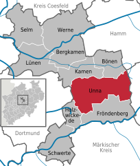
Unna (Unna)
- town in Unna District, in North Rhine-Westphalia, Germany
Unna, located in North Rhine-Westphalia, Germany, offers a variety of outdoor activities, including hiking. While it may not be as widely recognized for hiking as some other regions in Germany, there are several trails and natural areas nearby that can provide a rewarding hiking experience. Here are some highlights:
Local Trails
-
Wanderweg Unna: This is a local hiking trail that explores the surrounding countryside. You can expect scenic views, fields, and forested areas as you walk.
-
Bergisch Land: A short drive from Unna, the Bergisch Land region offers more extensive hiking opportunities, with trails that navigate through lush forests, hills, and valleys.
Nature Parks
- Hohensyburg: Located not far from Unna, the Hohensyburg area provides various hiking trails with striking views, particularly of the Ruhr Valley. The area has historical significance as well, with the ruins of Hohensyburg Castle to explore.
Helpful Tips
- Trail Maps: Make sure to pick up a local hiking map or download one to your smartphone for navigation.
- Weather Considerations: The weather can change, so it’s wise to check forecasts and dress in layers.
- Sustainability: Follow Leave No Trace principles to help preserve the natural beauty of the area.
Accessibility
Unna is well-connected by public transport, making it easy to reach nearby hiking locations. If you prefer more guided experiences, consider local hiking clubs or tours that might offer organized hikes in the region.
Whether you are looking for a gentle walk or a more challenging hike, Unna and its surrounding areas can provide a lovely outdoor experience!
- Country:

- Postal Code: 59427; 59425; 59423
- Local Dialing Code: 02308; 02303
- Licence Plate Code: UN
- Coordinates: 51° 32' 5" N, 7° 41' 20" E


- GPS tracks (wikiloc): [Link]
- AboveSeaLevel: 100 м m
- Area: 88.52 sq km
- Population: 57158
- Web site: http://www.unna.de
- Wikipedia en: wiki(en)
- Wikipedia: wiki(de)
- Wikidata storage: Wikidata: Q3949
- Wikipedia Commons Gallery: [Link]
- Wikipedia Commons Category: [Link]
- Wikipedia Commons Maps Category: [Link]
- Freebase ID: [/m/072b74]
- GeoNames ID: Alt: [2820087]
- BnF ID: [129291136]
- VIAF ID: Alt: [140869731]
- OSM relation ID: [158445]
- GND ID: Alt: [4061849-3]
- archINFORM location ID: [11202]
- MusicBrainz area ID: [e9fcf76b-556d-44b9-b88e-fa38982327ac]
- WOEID: [700617]
- SUDOC authorities ID: [056807430]
- Facebook Places ID: [107771569246034]
- ISNI: Alt: [0000 0001 2110 8369]
- NKCR AUT ID: [ge897778]
- Nomisma ID: [unna]
- German municipality key: 05978036
Shares border with regions:


Dortmund
- town in North Rhine-Westphalia, Germany
Dortmund, located in the North Rhine-Westphalia region of Germany, is not only known for its industrial heritage but also offers various opportunities for hiking and enjoying nature. Here are some highlights and tips for hiking in Dortmund:...
- Country:

- Postal Code: 44135–44388
- Local Dialing Code: 02304; 0231
- Licence Plate Code: DO
- Coordinates: 51° 30' 50" N, 7° 27' 55" E


- GPS tracks (wikiloc): [Link]
- AboveSeaLevel: 86 м m
- Area: 280.71 sq km
- Population: 585813
- Web site: [Link]

