
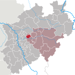
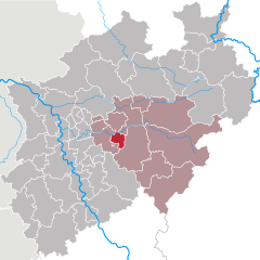
Dortmund (Dortmund)


- town in North Rhine-Westphalia, Germany
 Hiking in Dortmund
Dortmund, located in the North Rhine-Westphalia region of Germany, is not only known for its industrial heritage but also offers various opportunities for hiking and enjoying nature. Here are some highlights and tips for hiking in Dortmund:
1.
- Description: A large park featuring wooded areas, meadows, and lakes. It’s an excellent spot for leisurely walks and easy hikes.
- Trails: There are various winding paths that let you explore the landscape at a relaxed pace.
2.
- Description: This botanical garden and park offer serene hiking experiences amidst beautiful plant collections and landscapes.
- Activities: Enjoy birdwatching, picnicking, and botanical exploration as you walk through the park.
3.
- Description: A longer hiking path that follows the Emscher River, connecting cities in the region. It offers a blend of nature and urban landscapes.
- Distance: The entire trail stretches over 100 km, but you can choose shorter segments to hike based on your abilities and interests.
4.
- Description: Located in the former industrial area of Phoenix-West, this park has been developed to connect nature with the historical remnants of industry.
- Features: Trails through green spaces that highlight the area's industrial past, along with great views of the Ruhr area.
5.
- Day trips: While Dortmund itself has some lovely hiking spots, the nearby Sauerland region offers more extensive hiking opportunities with hills, forests, and stunning views. Popular trails include parts of the Rothaarsteig or the Sauerland Höhenweg.
6.
- Weather: Always check the weather before heading out, as conditions can change quickly.
- Dress appropriately: Wear comfortable and weather-appropriate hiking gear and sturdy footwear.
- Hydration and Snacks: Bring enough water and some snacks to keep your energy up, especially for longer hikes.
- Map and Navigation: Download maps or trails in advance or use a hiking app, as some paths may not be well-marked.
7.
Dortmund has excellent public transport options, including trains and buses, making it easy to access various hiking trails, especially for day trips to surrounding nature areas.
Whether you’re looking for a scenic stroll or a more challenging hike, Dortmund has options that suit a variety of preferences and skill levels. Enjoy your hike!
- Country:

- Postal Code: 44135–44388
- Local Dialing Code: 02304; 0231
- Licence Plate Code: DO
- Coordinates: 51° 30' 50" N, 7° 27' 55" E


- GPS tracks (wikiloc): [Link]
- AboveSeaLevel: 86 м m
- Area: 280.71 sq km
- Population: 585813
- Web site: https://www.dortmund.de/
- Wikipedia en: wiki(en)
- Wikipedia: wiki(de)
- Wikidata storage: Wikidata: Q1295
- Wikipedia Commons Gallery: [Link]
- Wikipedia Commons Category: [Link]
- Wikipedia Commons Maps Category: [Link]
- Freebase ID: [/m/0135k2]
- GeoNames ID: Alt: [6553133]
- VIAF ID: Alt: [147221598]
- OSM relation ID: [1829065]
- GND ID: Alt: [4012814-3]
- archINFORM location ID: [387]
- Library of Congress authority ID: Alt: [n80076227]
- MusicBrainz area ID: [20fdebf8-fdcc-49f0-845f-54147c735983]
- Quora topic ID: [Dortmund-Germany]
- UN/LOCODE: [DEDTM]
- Encyclopædia Britannica Online ID: [place/Dortmund]
- Encyclopædia Universalis ID: [dortmund]
- Facebook Places ID: [105758929457093]
- Great Russian Encyclopedia Online ID: [1966488]
- DMOZ ID: Alt: [Regional/Europe/Germany/States/North_Rhine-Westphalia/Localities/Dortmund/]
- NUTS code: [DEA52]
- Nomisma ID: [dortmund]
- Klexikon article ID: [Dortmund]
- German municipality key: 05913000
- GNS Unique Feature ID: -1761124
- German district key: 05913
Includes regions:
Aplerbeck (district)
- urban district of Dortmund, Germany
Hiking in Aplerbeck (district)
Stadtbezirk Aplerbeck, located in the southern part of Dortmund, Germany, offers a variety of hiking opportunities that cater to different skill levels and preferences. The region is characterized by its picturesque landscapes, green spaces, and accessible trails. Here are some highlights for hikers in Aplerbeck:...
- Country:
- Postal Code: 44263–44269
- Local Dialing Code: 0231
- Coordinates: 51° 29' 30" N, 7° 34' 0" E
- GPS tracks (wikiloc): [Link]


Hombruch (district)
- urban district of Dortmund, Germany
Hiking in Hombruch (district)
Stadtbezirk Hombruch is a district in Dortmund, Germany, that offers some interesting hiking opportunities amidst its natural beauty and local parks. While it may not be as widely recognized for hiking as more mountainous regions, there are still several trails and areas that cater to outdoor enthusiasts....
- Country:
- Postal Code: 44225–44229
- Local Dialing Code: 0231
- Coordinates: 51° 28' 33" N, 7° 26' 22" E
- GPS tracks (wikiloc): [Link]
- Area: 34.975 sq km
Mengede (district)
- urban district of Dortmund, Germany
Hiking in Mengede (district)
Stadtbezirk Mengede is a district located in the city of Dortmund, North Rhine-Westphalia, Germany. It offers a variety of outdoor recreational opportunities, including hiking. While Mengede may not be as well-known for extensive hiking trails compared to some larger nature reserves or mountainous regions in Germany, it still has its charms for those looking to explore the outdoors....
- Country:
- Postal Code: 44357; 44339
- Local Dialing Code: 0231
- Coordinates: 51° 34' 29" N, 7° 23' 6" E
- GPS tracks (wikiloc): [Link]
- AboveSeaLevel: 69 м m
Lütgendortmund (district)
- urban district of Dortmund, Germany
Hiking in Lütgendortmund (district)
Stadtbezirk Lütgendortmund is a district in the city of Dortmund, Germany, and while it may not be as famous for hiking as some of the more mountainous regions in Germany, there are still opportunities to explore the natural scenery and enjoy outdoor activities. Here’s an overview of what you might find:...
- Country:
- Postal Code: 44388
- Local Dialing Code: 0231
- Coordinates: 51° 30' 0" N, 7° 21' 0" E
- GPS tracks (wikiloc): [Link]
Hörde (district)
- urban district of Dortmund, Germany
Hiking in Hörde (district)
Hörde is a district located in Dortmund, Germany, known for its mixture of urban and natural landscapes. When it comes to hiking in Hörde, there are several aspects to consider:...
- Country:
- Postal Code: 44227
- Local Dialing Code: 0231
- Licence Plate Code: DO
- Coordinates: 51° 29' 0" N, 7° 30' 0" E
- GPS tracks (wikiloc): [Link]
- AboveSeaLevel: 112 м m
- Web site: [Link]
Brackel (district)
- urban district of Dortmund, Germany
Hiking in Brackel (district)
Stadtbezirk Brackel, located in the eastern part of Dortmund, Germany, offers various hiking opportunities for outdoor enthusiasts. While the area is more urbanized than rural regions, it still has access to nature and green spaces that can be explored by hikers....
- Country:
- Postal Code: 44319; 44309
- Local Dialing Code: 0231
- Coordinates: 51° 31' 0" N, 7° 34' 0" E
- GPS tracks (wikiloc): [Link]
- Area: 30.880 sq km
Huckarde (district)
- urban district of Dortmund, Germany
Hiking in Huckarde (district)
Hiking in Stadtbezirk Huckarde, located in Dortmund, Germany, can be a delightful experience for outdoor enthusiasts. The area offers a mix of urban landscapes and natural beauty, providing several opportunities for short hikes and longer trails....
- Country:
- Postal Code: 44369; 44379; 44359
- Local Dialing Code: 0231
- Coordinates: 51° 32' 0" N, 7° 24' 0" E
- GPS tracks (wikiloc): [Link]
- AboveSeaLevel: 75 м m
Dortmund Innenstadt-Nord (district)
- urban district of Dortmund, Germany
Hiking in Dortmund Innenstadt-Nord (district)
Stadtbezirk Innenstadt-Nord in Dortmund offers a unique blend of urban and natural landscapes, making it a great destination for hiking enthusiasts. While it may not have the extensive hiking trails found in more rural areas, there are several parks and green spaces where you can enjoy shorter hikes or walks amidst nature....
- Country:
- Postal Code: 44145−44147
- Local Dialing Code: 0231
- Coordinates: 51° 31' 45" N, 7° 28' 18" E
- GPS tracks (wikiloc): [Link]
- Area: 14.415 sq km
Dortmund Innenstadt-Ost (district)
- urban district of Dortmund, Germany
Hiking in Dortmund Innenstadt-Ost (district)
Stadtbezirk Innenstadt-Ost in Dortmund offers a unique blend of urban exploration and access to nature. While it's primarily considered an urban district, there are several opportunities for hiking and outdoor activities in and around the area....
- Country:
- Local Dialing Code: 0231
- Coordinates: 51° 30' 42" N, 7° 29' 38" E
- GPS tracks (wikiloc): [Link]


Dortmund Innenstadt-West (district)
- urban district of Dortmund, Germany
Hiking in Dortmund Innenstadt-West (district)
Stadtbezirk Innenstadt-West in Dortmund, Germany, is more urban than rural, meaning traditional hiking trails may not be as prominent as in more natural areas. However, there are several opportunities for walking, jogging, and enjoying the outdoors in and around this district....
- Country:
- Local Dialing Code: 0231
- Coordinates: 51° 30' 50" N, 7° 27' 55" E
- GPS tracks (wikiloc): [Link]
- AboveSeaLevel: 76 м m
- Area: 13.760 sq km
Scharnhorst (district)
- urban district of Dortmund, Germany
Hiking in Scharnhorst (district)
Stadtbezirk Scharnhorst, located in the northern part of Dortmund, Germany, offers a variety of hiking opportunities for outdoor enthusiasts. While it may not be as well-known as some of the larger natural parks or hiking regions, it still has its own charm and some appealing trails that can be explored....
- Country:
- Postal Code: 44319; 44139
- Local Dialing Code: 0231
- Coordinates: 51° 33' 0" N, 7° 32' 0" E
- GPS tracks (wikiloc): [Link]
- AboveSeaLevel: 71 м m
Eving (distict)
- urban district of Dortmund, Germany
Hiking in Eving (distict)
Stadtbezirk Eving is a district located in the city of Dortmund, Germany. It's characterized by its urban landscapes but also offers some green spaces and natural areas that can be explored through hiking. While not as extensive as national parks or larger nature reserves, there are still opportunities for hiking and enjoying the outdoors in and around Eving....
- Country:
- Postal Code: 44239–44339
- Local Dialing Code: 0231
- Coordinates: 51° 33' 0" N, 7° 28' 0" E
- GPS tracks (wikiloc): [Link]
- AboveSeaLevel: 93 м m
Shares border with regions:


Holzwickede
- municipality in the district of Unna in North Rhine-Westphalia, Germany
Hiking in Holzwickede
Holzwickede, located in North Rhine-Westphalia, Germany, offers various opportunities for hiking enthusiasts. The area is characterized by beautiful rural landscapes, parks, and green spaces that make it an excellent destination for nature walks and hikes....
- Country:
- Postal Code: 59439; 4755
- Local Dialing Code: 02301
- Licence Plate Code: UN
- Coordinates: 51° 30' 0" N, 7° 37' 0" E
- GPS tracks (wikiloc): [Link]
- AboveSeaLevel: 125 м m
- Area: 22.36 sq km
- Population: 17083
- Web site: [Link]


Ennepe-Ruhr-Kreis
- district in North Rhine-Westphalia, Germany
Hiking in Ennepe-Ruhr-Kreis
Ennepe-Ruhr-Kreis, located in North Rhine-Westphalia, Germany, is an excellent destination for hiking enthusiasts. The region is characterized by its diverse landscapes, which include forests, hills, and scenic views of the Ruhr area. Here are some key points to consider when hiking in this region:...
- Country:
- Capital: Schwelm
- Licence Plate Code: WIT; EN
- Coordinates: 51° 21' 5" N, 7° 18' 26" E
- GPS tracks (wikiloc): [Link]
- AboveSeaLevel: 226 м m
- Area: 408.44 sq km
- Population: 322731
- Web site: [Link]


Herdecke
- town in Ennepe-Ruhr-Kreis, North Rhine-Westphalia, Germany
Hiking in Herdecke
Herdecke is a charming town located in North Rhine-Westphalia, Germany, situated near the Ruhr River and surrounded by picturesque landscapes, making it a great destination for hiking enthusiasts. The region is characterized by rolling hills, forests, and scenic views, providing a variety of trails for different skill levels....
- Country:
- Postal Code: 58313
- Local Dialing Code: 02330
- Licence Plate Code: EN
- Coordinates: 51° 24' 0" N, 7° 26' 0" E
- GPS tracks (wikiloc): [Link]
- AboveSeaLevel: 150 м m
- Area: 22.4 sq km
- Population: 22836
- Web site: [Link]

Bochum
- city in North Rhine-Westphalia, Germany
Hiking in Bochum
Bochum, located in the North Rhine-Westphalia region of Germany, is not traditionally known as a hiking destination, but it offers some interesting opportunities for outdoor enthusiasts. Here are a few highlights for hiking in and around Bochum:...
- Country:
- Postal Code: 44701–44894
- Local Dialing Code: 02327; 0234
- Licence Plate Code: BO
- Coordinates: 51° 29' 0" N, 7° 13' 0" E
- GPS tracks (wikiloc): [Link]
- AboveSeaLevel: 100 м m
- Area: 145.66 sq km
- Population: 364920
- Web site: [Link]

Hagen
- German city in North Rhine-Westphalia
Hiking in Hagen
Hagen, located in North Rhine-Westphalia, Germany, offers a variety of hiking opportunities that showcase the area's natural beauty and diverse landscapes. Here are some highlights and tips for hiking in and around Hagen:...
- Country:
- Postal Code: 58000–58135
- Local Dialing Code: 02331; 02304; 02337; 02334
- Licence Plate Code: HA
- Coordinates: 51° 21' 34" N, 7° 28' 30" E
- GPS tracks (wikiloc): [Link]
- AboveSeaLevel: 106 м m
- Area: 160.45 sq km
- Population: 188266
- Web site: [Link]

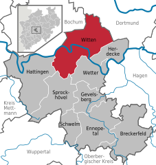
Witten
- town in the district of Ennepe-Ruhr-Kreis, in North Rhine-Westphalia, Germany
Hiking in Witten
Witten, located in North Rhine-Westphalia, Germany, offers a variety of hiking opportunities that showcase the region's natural beauty and historical sites. Here are some highlights for hiking in and around Witten:...
- Country:
- Postal Code: 58456; 58455; 58454; 58453; 58452
- Local Dialing Code: 02302
- Coordinates: 51° 26' 0" N, 7° 20' 0" E
- GPS tracks (wikiloc): [Link]
- AboveSeaLevel: 104 м m
- Area: 72.37 sq km
- Population: 96565
- Web site: [Link]


Lünen
- town in Unna District, in North Rhine-Westphalia, Germany
Hiking in Lünen
Lünen is a town located in North Rhine-Westphalia, Germany, and while it may not be typically known as a hiking hotspot, there are some lovely opportunities for outdoor enthusiasts in and around the area....
- Country:
- Postal Code: 44536; 44534; 44532
- Local Dialing Code: 02306; 0231
- Licence Plate Code: UN, LH, LÜN
- Coordinates: 51° 37' 0" N, 7° 31' 0" E
- GPS tracks (wikiloc): [Link]
- AboveSeaLevel: 58 м m
- Area: 59 sq km
- Population: 86465
- Web site: [Link]

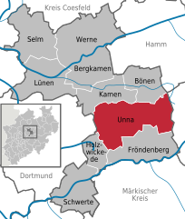
Unna
- town in Unna District, in North Rhine-Westphalia, Germany
Hiking in Unna
Unna, located in North Rhine-Westphalia, Germany, offers a variety of outdoor activities, including hiking. While it may not be as widely recognized for hiking as some other regions in Germany, there are several trails and natural areas nearby that can provide a rewarding hiking experience. Here are some highlights:...
- Country:
- Postal Code: 59427; 59425; 59423
- Local Dialing Code: 02308; 02303
- Licence Plate Code: UN
- Coordinates: 51° 32' 5" N, 7° 41' 20" E
- GPS tracks (wikiloc): [Link]
- AboveSeaLevel: 100 м m
- Area: 88.52 sq km
- Population: 57158
- Web site: [Link]

Unna
- district in North Rhine-Westphalia, Germany
Hiking in Unna
Unna is a district located in North Rhine-Westphalia, Germany, known for its beautiful landscapes and diverse recreational opportunities, including hiking. The region attracts outdoors enthusiasts due to its varied terrains, which can range from gentle hills to river valleys and forests....
- Country:
- Capital: Unna
- Licence Plate Code: UN
- Coordinates: 51° 34' 48" N, 7° 40' 12" E
- GPS tracks (wikiloc): [Link]
- AboveSeaLevel: 70 м m
- Web site: [Link]


Recklinghausen
- German district of North Rhine-Westphalia
Hiking in Recklinghausen
Recklinghausen, located in the state of North Rhine-Westphalia in Germany, offers a variety of hiking opportunities, primarily in the form of trails that showcase the region's natural beauty and cultural heritage. Here are some aspects to consider when planning a hike in and around Recklinghausen:...
- Country:
- Licence Plate Code: RE
- Coordinates: 51° 40' 12" N, 7° 10' 12" E
- GPS tracks (wikiloc): [Link]
- AboveSeaLevel: 52 м m
- Web site: [Link]


Schwerte
- town in the district of Unna, in North Rhine-Westphalia, Germany
Hiking in Schwerte
Schwerte, located in North Rhine-Westphalia, Germany, is a charming town that offers a variety of hiking opportunities, set within scenic landscapes characterized by forests, rivers, and hills. Here are some highlights and tips for hiking in the area:...
- Country:
- Postal Code: 58239
- Local Dialing Code: 02304
- Licence Plate Code: UN
- Coordinates: 51° 26' 45" N, 7° 33' 55" E
- GPS tracks (wikiloc): [Link]
- AboveSeaLevel: 120 м m
- Area: 56.2 sq km
- Population: 46641
- Web site: [Link]


Kamen
- town in Unna District, in North Rhine-Westphalia, Germany
Hiking in Kamen
Kamen, a city located in North Rhine-Westphalia, Germany, offers various hiking opportunities for both beginners and experienced hikers. Though it might not be as famous as some of Germany's larger nature reserves, the surrounding region features scenic landscapes and trails worth exploring....
- Country:
- Postal Code: 59174
- Local Dialing Code: 02307
- Licence Plate Code: UN
- Coordinates: 51° 35' 30" N, 7° 39' 55" E
- GPS tracks (wikiloc): [Link]
- AboveSeaLevel: 67 м m
- Area: 40.93 sq km
- Population: 43275
- Web site: [Link]