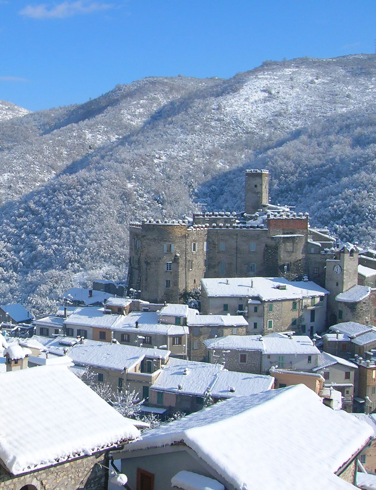
Vallinfreda (Vallinfreda)
.svg)
- Italian comune
 Hiking in Vallinfreda
Vallinfreda is a picturesque village located in the Lazio region of Italy, nestled in the Monti Simbruini National Park. This area is known for its beautiful landscapes, rich biodiversity, and a variety of hiking trails suitable for different skill levels. Here are some key points about hiking in Vallinfreda:
Hiking Trails
-
Monte Rappel: A popular hike in the area, this trail leads you to the summit of Monte Rappel, offering stunning panoramic views of the surrounding mountains and valleys.
-
Valle dell'Aniene: This trail takes you through the lush valleys and along the Aniene River, providing scenic views and opportunities for birdwatching.
-
Forest Trails: The Monti Simbruini National Park is rich in forests, with numerous trails that allow hikers to explore the diverse flora and fauna. Be sure to look out for local wildlife, including deer and various bird species.
Preparation and Safety
- Weather Considerations: Always check the weather before setting out, as conditions can change rapidly in mountainous areas.
- Gear: Wear appropriate hiking boots and bring layered clothing, as temperatures can fluctuate. Carry sufficient water, snacks, and a first-aid kit.
- Trail Maps: Having a reliable hiking map or GPS device is advisable, as some trails may not be well-marked.
Local Attractions
- After hiking, visitors can explore the charming village of Vallinfreda, with its historic architecture and local cuisine. This is a great way to relax and experience the culture of the region.
Best Time to Hike
- The ideal times for hiking in Vallinfreda are during the spring and autumn months when temperatures are mild and the landscapes are vibrant with blooming flora or autumn colors.
By following these guidelines and exploring the beautiful trails of Vallinfreda, hikers can enjoy both an adventurous and enriching outdoor experience!
- Country:

- Postal Code: 00020
- Local Dialing Code: 0774
- Licence Plate Code: RM
- Coordinates: 42° 5' 0" N, 12° 58' 0" E


- GPS tracks (wikiloc): [Link]
- AboveSeaLevel: 870 м m
- Area: 16.72 sq km
- Population: 291
- Web site: http://www.comunevallinfreda.rm.it/
- Wikipedia en: wiki(en)
- Wikipedia: wiki(it)
- Wikidata storage: Wikidata: Q243509
- Wikipedia Commons Category: [Link]
- Freebase ID: [/m/0gm8m2]
- GeoNames ID: Alt: [6539594]
- OSM relation ID: [41756]
- ISTAT ID: 058109
- Italian cadastre code: L625
Shares border with regions:

Cineto Romano
- Italian comune
Hiking in Cineto Romano
Cineto Romano is a charming village located in the Lazio region of Italy, not far from Rome. Nestled in the Sabine Hills, it's an excellent destination for hiking enthusiasts, offering a blend of natural beauty, historical sites, and cultural experiences....
- Country:
- Postal Code: 00020
- Local Dialing Code: 0774
- Licence Plate Code: RM
- Coordinates: 42° 3' 1" N, 12° 57' 54" E
- GPS tracks (wikiloc): [Link]
- AboveSeaLevel: 519 м m
- Area: 10.37 sq km
- Population: 586
- Web site: [Link]


Orvinio
- Italian comune
Hiking in Orvinio
Orvinio is a charming town located in the Sabina region of Italy, known for its stunning landscapes, ancient history, and rich cultural heritage. Hiking in and around Orvinio offers a range of experiences for outdoor enthusiasts. Here are some highlights:...
- Country:
- Postal Code: 02035
- Local Dialing Code: 0765
- Licence Plate Code: RI
- Coordinates: 42° 8' 0" N, 12° 56' 0" E
- GPS tracks (wikiloc): [Link]
- AboveSeaLevel: 840 м m
- Area: 24.69 sq km
- Population: 387
- Web site: [Link]


Percile
- Italian comune
Hiking in Percile
Percile is a beautiful area located in the region of Lazio, Italy, known for its picturesque landscapes, rich history, and numerous hiking opportunities. Situated near the Aniene Valley and surrounded by the Simbruini Mountains, it offers a variety of trails suitable for different skill levels. Here are some key points about hiking in Percile:...
- Country:
- Postal Code: 00020
- Local Dialing Code: 0774
- Licence Plate Code: RM
- Coordinates: 42° 5' 41" N, 12° 54' 31" E
- GPS tracks (wikiloc): [Link]
- AboveSeaLevel: 575 м m
- Area: 17.76 sq km
- Population: 233
- Web site: [Link]
Riofreddo
- Italian comune
Hiking in Riofreddo
Riofreddo is a picturesque village located in the province of Rome, Italy, surrounded by the stunning landscapes of the Apennine Mountains. It's a great destination for hiking enthusiasts, offering various trails that cater to different skill levels. Here are some highlights for hiking in the Riofreddo area:...
- Country:
- Postal Code: 00020
- Local Dialing Code: 0774
- Licence Plate Code: ROMA
- Coordinates: 42° 3' 32" N, 12° 59' 48" E
- GPS tracks (wikiloc): [Link]
- AboveSeaLevel: 705 м m
- Area: 12.38 sq km
- Population: 749
- Web site: [Link]


Vivaro Romano
- Italian comune
Hiking in Vivaro Romano
Vivaro Romano is a charming town located in the province of Rome, Italy, surrounded by stunning landscapes and natural beauty, making it a fantastic destination for hiking enthusiasts....
- Country:
- Postal Code: 00020
- Local Dialing Code: 0774
- Licence Plate Code: RM
- Coordinates: 42° 6' 2" N, 13° 0' 27" E
- GPS tracks (wikiloc): [Link]
- AboveSeaLevel: 756 м m
- Area: 12.54 sq km
- Population: 158
- Web site: [Link]


Oricola
- Italian comune
Hiking in Oricola
Oricola is a charming town located in the province of L'Aquila, in the Abruzzo region of Italy. It is known for its stunning natural landscapes, making it an excellent destination for hiking enthusiasts. Here are some key points to consider when hiking in Oricola:...
- Country:
- Postal Code: 67063
- Local Dialing Code: 0863
- Licence Plate Code: AQ
- Coordinates: 42° 3' 1" N, 13° 2' 22" E
- GPS tracks (wikiloc): [Link]
- AboveSeaLevel: 810 м m
- Area: 18.36 sq km
- Population: 1251
- Web site: [Link]