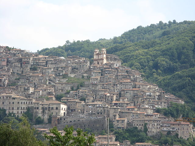
Valmontone (Valmontone)
.svg)
- Italian comune
 Hiking in Valmontone
Valmontone, located in the Lazio region of Italy, is not only known for its historical sites and proximity to the Rainbow Magicland amusement park but also offers some inviting hiking opportunities. Here are some aspects to consider if you're planning to hike in and around Valmontone:
Hiking Trails and Routes
-
Monti Prenestini: Just a short drive from Valmontone, the Monti Prenestini mountain range provides a range of hiking trails with varying levels of difficulty. The terrain features beautiful landscapes, forests, and panoramic views.
-
Regional Park of Castelli Romani: A bit further from Valmontone, this park offers numerous hiking routes, showcasing the stunning scenery of volcanic lakes and charming hill towns. The well-marked paths range from easy walks to more challenging hikes.
-
Local Trails: Valmontone itself has several trails that can be explored, often through the countryside, vineyards, and along the Aniene River. These paths are suitable for a leisurely hike and allow you to enjoy the local flora and fauna.
What to Expect
-
Scenery: The trails in the area are characterized by a mix of Mediterranean vegetation, ancient ruins, and breathtaking vistas. During your hike, you might encounter olive groves, vineyards, and heritage trees, creating a picturesque backdrop.
-
Wildlife: The region is home to various wildlife, including birds and small mammals. Keep an eye out for local fauna and listen to the sounds of nature as you hike.
-
Cultural Sites: Many trails will lead you to historical sites, such as old monasteries, castles, and traditional villages. This can add a unique cultural dimension to your hiking experience.
Tips for Hiking in Valmontone
-
Preparation: Always prepare adequately, wear good hiking shoes, and carry plenty of water, snacks, and a map or GPS device, as not all trails may be well-marked.
-
Best Time to Hike: Spring (April to June) and autumn (September to October) offer the best weather conditions for hiking, avoiding the heat of summer and the chill of winter.
-
Respect the Environment: Stick to marked trails, take your litter with you, and respect wildlife and plant life.
Local Resources
- Guided Tours: If you're unfamiliar with the area, consider joining a guided hiking tour, which can provide insights into the local ecology and history.
- Visitor Centers: Check with local visitor centers for maps, information on current trail conditions, and recommendations specific to your interests and skill level.
Conclusion
Hiking in Valmontone offers an opportunity to immerse yourself in the natural beauty and cultural heritage of Italy. Whether you're an experienced hiker or just looking for a leisurely walk, you can find trails that suit your preference. Make sure to enjoy the stunning views and rich history the region has to offer!
- Country:

- Postal Code: 00038
- Local Dialing Code: 06
- Licence Plate Code: ROMA
- Coordinates: 41° 46' 24" N, 12° 55' 7" E


- GPS tracks (wikiloc): [Link]
- AboveSeaLevel: 303 м m
- Area: 40.91 sq km
- Population: 16073
- Web site: http://www.comunevalmontone.it
- Wikipedia en: wiki(en)
- Wikipedia: wiki(it)
- Wikidata storage: Wikidata: Q243514
- Wikipedia Commons Category: [Link]
- Freebase ID: [/m/08qc_p]
- GeoNames ID: Alt: [6542046]
- BnF ID: [15125644x]
- VIAF ID: Alt: [167468901]
- OSM relation ID: [41531]
- MusicBrainz area ID: [95431bdc-4e70-416a-be0a-4219acdd786c]
- UN/LOCODE: [ITVME]
- ISTAT ID: 058110
- Italian cadastre code: L639
Shares border with regions:
Cave
- comune in Italy
Hiking in Cave
Cave, located in the province of Rome in the Lazio region of Italy, offers a charming escape for hikers and nature enthusiasts. The area is characterized by its picturesque landscapes, rich history, and diverse flora and fauna....
- Country:
- Postal Code: 00033
- Local Dialing Code: 06
- Licence Plate Code: RM
- Coordinates: 41° 49' 0" N, 12° 56' 0" E
- GPS tracks (wikiloc): [Link]
- AboveSeaLevel: 399 м m
- Area: 17.88 sq km
- Population: 11381
- Web site: [Link]

Artena
- Italian comune
Hiking in Artena
Artena is a charming hilltop town located in the province of Rome, Italy. It is set in the beautiful landscape of the Lazio region, surrounded by hills, forests, and panoramic views, making it a great destination for hiking enthusiasts. Here are a few highlights about hiking in and around Artena:...
- Country:
- Postal Code: 00031
- Local Dialing Code: 06
- Licence Plate Code: RM
- Coordinates: 41° 44' 0" N, 12° 55' 0" E
- GPS tracks (wikiloc): [Link]
- AboveSeaLevel: 420 м m
- Area: 54.8 sq km
- Population: 14107
- Web site: [Link]


Colleferro
- Italian comune
Hiking in Colleferro
Colleferro, located in the Lazio region of Italy, offers a variety of hiking opportunities thanks to its picturesque landscapes and proximity to the beautiful Monti Lepini mountain range. Here’s a breakdown of what you can expect when hiking in and around Colleferro:...
- Country:
- Postal Code: 00034
- Local Dialing Code: 06
- Licence Plate Code: ROMA
- Coordinates: 41° 43' 43" N, 13° 0' 11" E
- GPS tracks (wikiloc): [Link]
- AboveSeaLevel: 218 м m
- Area: 27 sq km
- Population: 21394
- Web site: [Link]
Genazzano
- Italian comune
Hiking in Genazzano
Genazzano, a charming medieval town in the Lazio region of Italy, offers wonderful opportunities for hiking and exploring the surrounding landscapes. Nestled in the hills near the Aniene Valley, Genazzano is known for its picturesque views, historic architecture, and lush natural surroundings....
- Country:
- Postal Code: 00030
- Local Dialing Code: 06
- Licence Plate Code: ROMA
- Coordinates: 41° 50' 0" N, 12° 58' 0" E
- GPS tracks (wikiloc): [Link]
- AboveSeaLevel: 375 м m
- Area: 32.07 sq km
- Population: 5949
- Web site: [Link]
Labico
- Italian comune
Hiking in Labico
Labico is a charming town located in the province of Rome, Italy, and it offers several opportunities for outdoor enthusiasts, including hiking. The surrounding area boasts beautiful landscapes, including hills, forests, and vineyards, making it an attractive destination for nature lovers....
- Country:
- Postal Code: 00030
- Local Dialing Code: 06
- Licence Plate Code: ROMA
- Coordinates: 41° 47' 0" N, 12° 53' 0" E
- GPS tracks (wikiloc): [Link]
- AboveSeaLevel: 319 м m
- Area: 11.75 sq km
- Population: 6469
- Web site: [Link]


Palestrina
- Italian comune
Hiking in Palestrina
Palestrina, located just east of Rome, Italy, is not only rich in history but also offers various hiking opportunities that blend natural beauty with cultural exploration. Here are some aspects of hiking in Palestrina:...
- Country:
- Postal Code: 00036
- Local Dialing Code: 06
- Licence Plate Code: ROMA
- Coordinates: 41° 50' 0" N, 12° 54' 0" E
- GPS tracks (wikiloc): [Link]
- AboveSeaLevel: 450 м m
- Area: 47.02 sq km
- Population: 21872
- Web site: [Link]