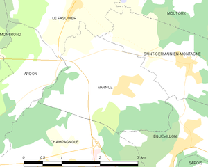
Vannoz (Vannoz)
- commune in Jura, France
It seems like there might be a bit of confusion regarding the name "Vannoz," as it doesn't correspond to a well-known hiking location or trail in major hiking databases or resources. However, it's possible that you might be referring to a specific region, local area, or perhaps a less-known trail that hasn't gained widespread recognition.
If you have more context or specifics about Vannoz, such as its location (country, region, or any landmarks) or particular trails you have in mind, I would be glad to provide tailored information about hiking in that area.
In general, valuable aspects to consider for hiking include:
- Trail Difficulty: Knowing whether the trails are suitable for beginners or experienced hikers helps in planning.
- Safety: Always check for weather conditions, trail advisories, and necessary permits.
- Wildlife: Understanding local wildlife can enhance your hiking experience, but also requires awareness and precautions.
- Gear: Depending on the terrain and climate, ensure you have the appropriate clothing, footwear, and supplies.
- Leave No Trace: Engage in hiking practices that protect the environment.
If you need help with a specific trail or region, feel free to provide more details!
- Country:

- Postal Code: 39300
- Coordinates: 46° 46' 22" N, 5° 55' 1" E


- GPS tracks (wikiloc): [Link]
- Area: 5.75 sq km
- Population: 205
- Wikipedia en: wiki(en)
- Wikipedia: wiki(fr)
- Wikidata storage: Wikidata: Q670619
- Wikipedia Commons Category: [Link]
- Freebase ID: [/m/03nvvk8]
- GeoNames ID: Alt: [2970771]
- SIREN number: [213905433]
- BnF ID: [15258902b]
- INSEE municipality code: 39543
Shares border with regions:


Équevillon
- commune in Jura, France
Équevillon is a charming village located in the Jura department in eastern France, known for its beautiful landscapes and outdoor activities. Hiking enthusiasts will find plenty of opportunities to explore the surrounding natural beauty. Here’s what you can expect when hiking in and around Équevillon:...
- Country:

- Postal Code: 39300
- Coordinates: 46° 45' 33" N, 5° 56' 17" E


- GPS tracks (wikiloc): [Link]
- Area: 4.84 sq km
- Population: 583


Champagnole
- commune in Jura, France
Champagnole is a charming town located in the Jura region of France, known for its beautiful natural landscapes and outdoor recreational opportunities. The surrounding area offers a variety of hiking trails that cater to different skill levels, making it an excellent destination for hikers....
- Country:

- Postal Code: 39300
- Coordinates: 46° 44' 50" N, 5° 54' 26" E


- GPS tracks (wikiloc): [Link]
- Area: 20.18 sq km
- Population: 7916
- Web site: [Link]


Ardon
- commune in Jura, France
Ardon, located in the Jura region of Switzerland, offers a range of beautiful hiking opportunities that cater to various skill levels. The Jura mountains are known for their rolling hills, lush forests, and panoramic views. Here are some highlights and tips for hiking in the area:...
- Country:

- Postal Code: 39300
- Coordinates: 46° 46' 26" N, 5° 53' 17" E


- GPS tracks (wikiloc): [Link]
- Area: 5.04 sq km
- Population: 116


Saint-Germain-en-Montagne
- commune in Jura, France
 Hiking in Saint-Germain-en-Montagne
Saint-Germain-en-Montagne is a charming village located in the Jura department of France, known for its beautiful natural landscapes, rolling hills, and rich biodiversity, making it an ideal spot for hiking enthusiasts. Here are some highlights and tips for hiking in and around Saint-Germain-en-Montagne:...
- Country:

- Postal Code: 39300
- Coordinates: 46° 46' 38" N, 5° 56' 23" E


- GPS tracks (wikiloc): [Link]
- Area: 5.35 sq km
- Population: 439


Le Pasquier
- commune in Jura, France
Le Pasquier is a wonderful destination for hiking enthusiasts. While the specific region may vary, if you’re referring to a hiking area known as Le Pasquier in France, it is often characterized by stunning natural beauty, picturesque landscapes, and a variety of trails suitable for different skill levels....
- Country:

- Postal Code: 39300
- Coordinates: 46° 48' 2" N, 5° 54' 19" E


- GPS tracks (wikiloc): [Link]
- Area: 7.75 sq km
- Population: 263
- Web site: [Link]
