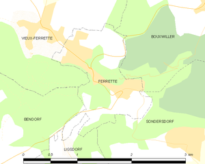
Vieux-Ferrette (Vieux-Ferrette)

- commune in Haut-Rhin, France
 Hiking in Vieux-Ferrette
Vieux-Ferrette is a charming village located in the Alsace region of northeastern France, near the border with Switzerland and Germany. This area is often celebrated for its picturesque landscapes, rich history, and diverse outdoor activities, making it a great destination for hiking enthusiasts.
Hiking Opportunities:
-
Scenic Trails: Vieux-Ferrette provides access to a variety of hiking trails that wind through lush forests, rolling hills, and vineyards. The surrounding terrain offers both challenging routes and more leisurely walks, making it suitable for hikers of all levels.
-
Historical Routes: Some hiking paths might take you past historical sites, including old ruins such as the remnants of the Ferrette Castle, which dates back to the 11th century. Exploring these sites adds an educational aspect to your hike.
-
Nature Trails: The region is rich in biodiversity, with opportunities to observe local flora and fauna. Hiking in this area can be a rewarding experience for nature lovers, especially during the spring and summer months when wildflowers are in bloom and wildlife is active.
-
Panoramic Views: Many trails offer stunning panoramic views of the surrounding valleys and the Jura mountains. Ascending to higher elevations can reward hikers with breathtaking vistas, especially from lookout points along the routes.
-
Local Gastronomy: After a day of hiking, you can indulge in the local cuisine at nearby restaurants. Alsace is known for its hearty dishes, wines, and traditional food, which can provide a great way to recharge after a long trek.
Practical Tips:
-
Maps and Signage: It’s advisable to carry a detailed hiking map or use a GPS device, as trail signage may vary. Local tourist offices can provide maps and information on current trail conditions.
-
Weather Considerations: The weather can change rapidly in this region, so it's essential to check conditions before heading out. Layered clothing and rain gear are advisable, especially in the spring and fall.
-
Water and Snacks: Always carry sufficient water and snacks to keep your energy up while hiking. Some trails may not have easy access to water sources.
-
Safety: Ensure that you are aware of your hiking abilities and choose trails that suit your level of fitness. Inform someone of your plans and expected return time, especially if hiking solo.
Conclusion:
Hiking in Vieux-Ferrette offers a blend of natural beauty, cultural experiences, and outdoor adventure. It's a great opportunity to explore the charm of Alsace while enjoying the wonders of nature. Whether you’re looking for a peaceful stroll or a more challenging trek, this region has something to offer every hiker.
- Country:

- Postal Code: 68480
- Coordinates: 47° 30' 9" N, 7° 17' 57" E


- GPS tracks (wikiloc): [Link]
- Area: 6.63 sq km
- Population: 673
- Wikipedia en: wiki(en)
- Wikipedia: wiki(fr)
- Wikidata storage: Wikidata: Q122391
- Wikipedia Commons Category: [Link]
- Freebase ID: [/m/03nsv44]
- Freebase ID: [/m/03nsv44]
- Freebase ID: [/m/03nsv44]
- GeoNames ID: Alt: [6441653]
- GeoNames ID: Alt: [6441653]
- GeoNames ID: Alt: [6441653]
- SIREN number: [216803478]
- SIREN number: [216803478]
- SIREN number: [216803478]
- BnF ID: [15272049g]
- BnF ID: [15272049g]
- BnF ID: [15272049g]
- OSM relation ID: [391070]
- OSM relation ID: [391070]
- OSM relation ID: [391070]
- INSEE municipality code: 68347
- INSEE municipality code: 68347
- INSEE municipality code: 68347
Shares border with regions:


Kœstlach
- commune in Haut-Rhin, France
Hiking in Kœstlach
Kœstlach is a charming area located in the Alsace region of France, near the Swiss border. While it may not be as widely recognized as other hiking destinations, it offers beautiful landscapes, lush forests, and a closer connection to nature....
- Country:
- Postal Code: 68480
- Coordinates: 47° 30' 22" N, 7° 16' 16" E
- GPS tracks (wikiloc): [Link]
- Area: 8.23 sq km
- Population: 508


Riespach
- commune in Haut-Rhin, France
Hiking in Riespach
Riespach is a small region in the Vosges mountains of France, known for its picturesque landscapes and outdoor activities, including hiking. Here are some key points to consider if you plan to hike in Riespach:...
- Country:
- Postal Code: 68640
- Coordinates: 47° 32' 26" N, 7° 17' 15" E
- GPS tracks (wikiloc): [Link]
- Area: 7.57 sq km
- Population: 686


Roppentzwiller
- commune in Haut-Rhin, France
Hiking in Roppentzwiller
Roppentzwiller is a small village located in the Alsace region of France, near the border with Switzerland. This area boasts beautiful landscapes and offers a variety of hiking opportunities for outdoor enthusiasts. Here are some key points to consider when hiking in and around Roppentzwiller:...
- Country:
- Postal Code: 68480
- Coordinates: 47° 32' 25" N, 7° 19' 55" E
- GPS tracks (wikiloc): [Link]
- Area: 4.15 sq km
- Population: 696


Bouxwiller
- commune in Haut-Rhin, France
Hiking in Bouxwiller
Bouxwiller is a charming village located in the Haut-Rhin department of France, known for its beautiful landscapes and scenic hiking opportunities. The region offers a variety of trails that cater to different skill levels, making it suitable for both beginner and experienced hikers....
- Country:
- Postal Code: 68480
- Coordinates: 47° 30' 18" N, 7° 20' 45" E
- GPS tracks (wikiloc): [Link]
- Area: 6.47 sq km
- Population: 463

Ferrette
- commune in Haut-Rhin, France
Hiking in Ferrette
Ferrette, a picturesque small town located in the Alsace region of France, is nestled near the border with Switzerland. It offers a variety of hiking opportunities, surrounded by beautiful landscapes, forests, and rolling hills. Here are some highlights and tips for hiking in the Ferrette area:...
- Country:
- Postal Code: 68480
- Coordinates: 47° 29' 38" N, 7° 18' 57" E
- GPS tracks (wikiloc): [Link]
- Area: 1.94 sq km
- Population: 683


Bendorf
- commune in Haut-Rhin, France
Hiking in Bendorf
Bendorf is a small commune located in the Haut-Rhin department in the Alsace region of France. While it may not be as widely recognized as some of the larger hiking destinations in the area, it can offer scenic trails and beautiful landscapes typical of the Alsatian countryside....
- Country:
- Postal Code: 68480
- Coordinates: 47° 29' 15" N, 7° 16' 54" E
- GPS tracks (wikiloc): [Link]
- Area: 7.55 sq km
- Population: 208


Durmenach
- commune in Haut-Rhin, France
Hiking in Durmenach
Durmenach is a charming area surrounded by beautiful landscapes, ideal for hiking enthusiasts. While specific trail information may vary, here are general points about hiking in and around Durmenach:...
- Country:
- Postal Code: 68480
- Coordinates: 47° 31' 37" N, 7° 20' 17" E
- GPS tracks (wikiloc): [Link]
- Area: 5.76 sq km
- Population: 859

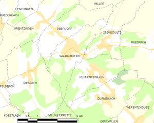
Waldighofen
- commune in Haut-Rhin, France
Hiking in Waldighofen
Waldighofen is a charming village located in the Alsace region of France, known for its picturesque landscapes and outdoor activities, including hiking. When hiking in Waldighofen, you can expect scenic views, a mix of forests, fields, and vineyards, as well as a mild climate suitable for year-round exploration....
- Country:
- Postal Code: 68640
- Coordinates: 47° 33' 3" N, 7° 19' 0" E
- GPS tracks (wikiloc): [Link]
- Area: 4.14 sq km
- Population: 1544
- Web site: [Link]