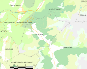
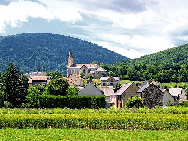
Villard-Saint-Christophe (Villard-Saint-Christophe)

- commune in Isère, France
 Hiking in Villard-Saint-Christophe
Villard-Saint-Christophe is a picturesque village located in the Isère department of the Auvergne-Rhône-Alpes region in France. It offers a variety of hiking opportunities that showcase the stunning natural scenery of the region, including mountains, lakes, and lush forests.
Hiking Opportunities
-
Trails: There are several marked trails in and around Villard-Saint-Christophe suitable for various skill levels, from gentle walks to more challenging hikes.
-
Scenic Views: Many trails offer breathtaking views of the surrounding mountains and valleys, including the Chartreuse and Vercors ranges. Be sure to take your camera to capture the stunning landscapes.
-
Wildlife: The area is rich in biodiversity. Keep an eye out for local wildlife, including deer, foxes, and a variety of bird species.
-
Historical Sites: Along the trails, you may encounter historical features, like old farms and churches, providing a glimpse into the region's past.
-
Seasonal Considerations: The hiking season generally runs from spring to early autumn. In winter, some trails might be used for snowshoeing or cross-country skiing, depending on snow conditions.
Preparation and Tips
- Maps and Guides: Make sure to carry a detailed map of the area or download a hiking app to help navigate the trails.
- Equipment: Wear sturdy hiking boots and dress in layers; temperatures can vary significantly throughout the day.
- Hydration and Snacks: Bring plenty of water and some snacks to keep your energy levels up during your hikes.
- Weather: Check the weather forecast before you head out, as conditions can change rapidly in mountainous areas.
- Respect Nature: Follow the Leave No Trace principles to preserve the natural beauty of the area.
Additional Activities
Beyond hiking, Villard-Saint-Christophe and the surrounding region offer opportunities for rock climbing, cycling, and even paragliding for the adventure-seeking enthusiast.
Overall, hiking in Villard-Saint-Christophe can be a rewarding experience for nature lovers and adventure seekers alike, offering an excellent way to explore the natural beauty and cultural richness of the French Alps.
- Country:

- Postal Code: 38119
- Coordinates: 44° 58' 44" N, 5° 48' 21" E


- GPS tracks (wikiloc): [Link]
- Area: 14.22 sq km
- Population: 408
- Wikipedia en: wiki(en)
- Wikipedia: wiki(fr)
- Wikidata storage: Wikidata: Q1149960
- Wikipedia Commons Category: [Link]
- Freebase ID: [/m/03g_0vd]
- GeoNames ID: Alt: [6433460]
- SIREN number: [213805526]
- BnF ID: [152583527]
- VIAF ID: Alt: [316738459]
- INSEE municipality code: 38552
Shares border with regions:


Lavaldens
- commune in Isère, France
Hiking in Lavaldens
Lavaldens is a beautiful destination for hiking enthusiasts, located in the stunning region of the Italian Alps, specifically within the Province of Trento. The area is known for its picturesque landscapes, charming villages, and a variety of trails suitable for different levels of hikers. Here are some key points to consider when hiking in Lavaldens:...
- Country:
- Postal Code: 38350
- Coordinates: 44° 58' 58" N, 5° 53' 15" E
- GPS tracks (wikiloc): [Link]
- Area: 41.4 sq km
- Population: 163

La Morte
- commune in Isère, France
Hiking in La Morte
La Morte, located in the French Alps, is a lesser-known but breathtaking area for hiking enthusiasts. It is characterized by its stunning landscapes, including rugged mountains, lush valleys, and pristine lakes. Here are some key points to consider when hiking in La Morte:...
- Country:
- Postal Code: 38350
- Coordinates: 45° 1' 47" N, 5° 51' 22" E
- GPS tracks (wikiloc): [Link]
- Area: 19.45 sq km
- Population: 133
- Web site: [Link]


Saint-Honoré
- commune in Isère, France
Hiking in Saint-Honoré
Saint-Honoré is a charming village located in the Isère department of the Auvergne-Rhône-Alpes region in southeastern France. It is surrounded by the beautiful Vercors and Chartreuse mountain ranges, making it an excellent base for hiking enthusiasts. Here are some highlights and tips for hiking in and around Saint-Honoré:...
- Country:
- Postal Code: 38350
- Coordinates: 44° 57' 16" N, 5° 48' 24" E
- GPS tracks (wikiloc): [Link]
- Area: 14.58 sq km
- Population: 806


Saint-Théoffrey
- commune in Isère, France
Hiking in Saint-Théoffrey
Saint-Théoffrey, located in the Isère department of the Auvergne-Rhône-Alpes region in southeastern France, offers a variety of scenic hiking opportunities. Nestled in the stunning Vercors Regional Natural Park, this charming village is surrounded by captivating landscapes that are perfect for both novice and experienced hikers....
- Country:
- Postal Code: 38119
- Coordinates: 44° 59' 56" N, 5° 46' 23" E
- GPS tracks (wikiloc): [Link]
- Area: 5.75 sq km
- Population: 492
- Web site: [Link]

Pierre-Châtel
- commune in Isère, France
Hiking in Pierre-Châtel
Pierre-Châtel, located in the French Alps in the Isère department, offers a variety of hiking opportunities that showcase stunning natural landscapes and diverse terrains. Here are some key points to consider when hiking in the area:...
- Country:
- Postal Code: 38119
- Coordinates: 44° 57' 25" N, 5° 46' 34" E
- GPS tracks (wikiloc): [Link]
- Area: 11.48 sq km
- Population: 1504
- Web site: [Link]


Cholonge
- commune in Isère, France
Hiking in Cholonge
Cholonge is known for its picturesque landscapes and diverse hiking opportunities. Nestled in a natural setting, it offers trails that cater to various skill levels, from beginners to experienced hikers. Here are some highlights you might find while hiking in Cholonge:...
- Country:
- Postal Code: 38220
- Coordinates: 45° 0' 15" N, 5° 47' 48" E
- GPS tracks (wikiloc): [Link]
- Area: 8.92 sq km
- Population: 323