Cholonge (Cholonge)

- commune in Isère, France
 Hiking in Cholonge
Cholonge is known for its picturesque landscapes and diverse hiking opportunities. Nestled in a natural setting, it offers trails that cater to various skill levels, from beginners to experienced hikers. Here are some highlights you might find while hiking in Cholonge:
-
Scenic Views: The trails often feature breathtaking vistas of the surrounding mountains, valleys, and forests. Sunrise and sunset hikes can provide particularly stunning views.
-
Flora and Fauna: The region's biodiversity allows hikers to experience a variety of plant life and wildlife. Keep your eyes peeled for local species, as well as unique ecosystems along the trails.
-
Trail Conditions: The trails can vary in difficulty. Some may have well-marked paths and relatively easy terrain, while others might involve steep climbs or rocky paths, requiring good footwear and physical fitness.
-
Cultural Sites: Depending on the specific trails you choose, you might encounter cultural or historical landmarks, such as ancient ruins, traditional villages, or local artisan markets.
-
Camping Opportunities: If you're looking for a multi-day adventure, there may be campsites along the trails where you can set up for the night. Be sure to check local regulations about camping.
-
Best Time to Hike: The best hiking season typically depends on the climate of the region. Spring and fall usually offer mild temperatures and stunning natural displays, but summer can be great as well, though it might be hotter.
-
Safety Tips: Always carry sufficient water, wear appropriate clothing, and inform someone of your hiking plans. Having a map or GPS device can also be helpful to navigate the trails.
Before you go, it's a good idea to check local resources for trail conditions, any permits that may be needed, and recommendations from local hiking groups. Enjoy your adventure in Cholonge!
- Country:

- Postal Code: 38220
- Coordinates: 45° 0' 15" N, 5° 47' 48" E


- GPS tracks (wikiloc): [Link]
- Area: 8.92 sq km
- Population: 323
- Wikipedia en: wiki(en)
- Wikipedia: wiki(fr)
- Wikidata storage: Wikidata: Q574315
- Wikipedia Commons Category: [Link]
- Freebase ID: [/m/03g_11p]
- GeoNames ID: Alt: [6433166]
- SIREN number: [213801061]
- BnF ID: [152579321]
- WOEID: [585928]
- INSEE municipality code: 38106
Shares border with regions:

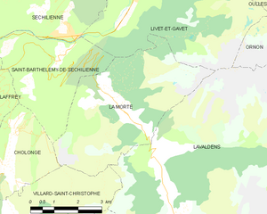
La Morte
- commune in Isère, France
Hiking in La Morte
La Morte, located in the French Alps, is a lesser-known but breathtaking area for hiking enthusiasts. It is characterized by its stunning landscapes, including rugged mountains, lush valleys, and pristine lakes. Here are some key points to consider when hiking in La Morte:...
- Country:
- Postal Code: 38350
- Coordinates: 45° 1' 47" N, 5° 51' 22" E
- GPS tracks (wikiloc): [Link]
- Area: 19.45 sq km
- Population: 133
- Web site: [Link]


Saint-Théoffrey
- commune in Isère, France
Hiking in Saint-Théoffrey
Saint-Théoffrey, located in the Isère department of the Auvergne-Rhône-Alpes region in southeastern France, offers a variety of scenic hiking opportunities. Nestled in the stunning Vercors Regional Natural Park, this charming village is surrounded by captivating landscapes that are perfect for both novice and experienced hikers....
- Country:
- Postal Code: 38119
- Coordinates: 44° 59' 56" N, 5° 46' 23" E
- GPS tracks (wikiloc): [Link]
- Area: 5.75 sq km
- Population: 492
- Web site: [Link]

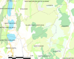
Villard-Saint-Christophe
- commune in Isère, France
Hiking in Villard-Saint-Christophe
Villard-Saint-Christophe is a picturesque village located in the Isère department of the Auvergne-Rhône-Alpes region in France. It offers a variety of hiking opportunities that showcase the stunning natural scenery of the region, including mountains, lakes, and lush forests....
- Country:
- Postal Code: 38119
- Coordinates: 44° 58' 44" N, 5° 48' 21" E
- GPS tracks (wikiloc): [Link]
- Area: 14.22 sq km
- Population: 408


Saint-Barthélemy-de-Séchilienne
- commune in Isère, France
Hiking in Saint-Barthélemy-de-Séchilienne
Saint-Barthélemy-de-Séchilienne is a charming commune situated in the Isère department of the Auvergne-Rhône-Alpes region in southeastern France. Nestled in the foothills of the French Alps, this area offers beautiful scenery and a range of hiking opportunities for outdoor enthusiasts. Here's what you can expect when hiking in this region:...
- Country:
- Postal Code: 38220
- Coordinates: 45° 2' 39" N, 5° 49' 34" E
- GPS tracks (wikiloc): [Link]
- AboveSeaLevel: 450 м m
- Area: 12.1 sq km
- Population: 454


Laffrey
- commune in Isère, France
Hiking in Laffrey
Laffrey is a beautiful area located near Grenoble in the French Alps, offering stunning natural landscapes and a variety of hiking opportunities. Here are some details to help enhance your hiking experience in Laffrey:...
- Country:
- Postal Code: 38220
- Coordinates: 45° 1' 29" N, 5° 46' 25" E
- GPS tracks (wikiloc): [Link]
- Area: 6.72 sq km
- Population: 429
- Web site: [Link]