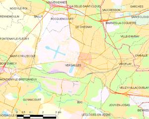
Ville-d'Avray (Ville-d'Avray)
- commune in Hauts-de-Seine, France
- Country:

- Postal Code: 92410
- Coordinates: 48° 49' 34" N, 2° 11' 36" E


- GPS tracks (wikiloc): [Link]
- AboveSeaLevel: 125 м m
- Area: 3.67 sq km
- Population: 11422
- Web site: http://www.mairie-villedavray.fr
- Wikipedia en: wiki(en)
- Wikipedia: wiki(fr)
- Wikidata storage: Wikidata: Q456327
- Wikipedia Commons Category: [Link]
- Freebase ID: [/m/07xmgg]
- Freebase ID: [/m/07xmgg]
- Freebase ID: [/m/07xmgg]
- GeoNames ID: Alt: [2968819]
- GeoNames ID: Alt: [2968819]
- GeoNames ID: Alt: [2968819]
- SIREN number: [219200771]
- SIREN number: [219200771]
- SIREN number: [219200771]
- BnF ID: [15280279p]
- BnF ID: [15280279p]
- BnF ID: [15280279p]
- VIAF ID: Alt: [142810395]
- VIAF ID: Alt: [142810395]
- VIAF ID: Alt: [142810395]
- GND ID: Alt: [4353060-6]
- GND ID: Alt: [4353060-6]
- GND ID: Alt: [4353060-6]
- archINFORM location ID: [575]
- archINFORM location ID: [575]
- archINFORM location ID: [575]
- Library of Congress authority ID: Alt: [n85307961]
- Library of Congress authority ID: Alt: [n85307961]
- Library of Congress authority ID: Alt: [n85307961]
- PACTOLS thesaurus ID: [pcrtgXXj1a7eGe]
- PACTOLS thesaurus ID: [pcrtgXXj1a7eGe]
- PACTOLS thesaurus ID: [pcrtgXXj1a7eGe]
- MusicBrainz area ID: [3eadf776-15b7-4bb8-a3d2-cdcb01789f52]
- MusicBrainz area ID: [3eadf776-15b7-4bb8-a3d2-cdcb01789f52]
- MusicBrainz area ID: [3eadf776-15b7-4bb8-a3d2-cdcb01789f52]
- TGN ID: [1036131]
- TGN ID: [1036131]
- TGN ID: [1036131]
- Twitter username: Alt: [vdavray]
- Twitter username: Alt: [vdavray]
- Twitter username: Alt: [vdavray]
- data.gouv.fr org ID: [mairie-de-ville-davray]
- data.gouv.fr org ID: [mairie-de-ville-davray]
- data.gouv.fr org ID: [mairie-de-ville-davray]
- INSEE municipality code: 92077
- INSEE municipality code: 92077
- INSEE municipality code: 92077
Shares border with regions:


Saint-Cloud
- commune in Hauts-de-Seine, France
- Country:

- Postal Code: 92210
- Coordinates: 48° 50' 47" N, 2° 12' 55" E


- GPS tracks (wikiloc): [Link]
- AboveSeaLevel: 136 м m
- Area: 7.56 sq km
- Population: 29362
- Web site: [Link]


Sèvres
- Commune in Hauts-de-Seine, France
- Country:

- Postal Code: 92310
- Coordinates: 48° 49' 23" N, 2° 12' 39" E


- GPS tracks (wikiloc): [Link]
- AboveSeaLevel: 95 м m
- Area: 3.91 sq km
- Population: 23332
- Web site: [Link]


Chaville
- commune in Hauts-de-Seine, France
- Country:

- Postal Code: 92370
- Coordinates: 48° 48' 31" N, 2° 11' 19" E


- GPS tracks (wikiloc): [Link]
- Area: 3.55 sq km
- Population: 20001
- Web site: [Link]


Versailles
- commune in Yvelines, France
- Country:

- Postal Code: 78000
- Coordinates: 48° 48' 17" N, 2° 8' 3" E


- GPS tracks (wikiloc): [Link]
- AboveSeaLevel: 180 м m
- Area: 26.18 sq km
- Population: 85771
- Web site: [Link]


Marnes-la-Coquette
- commune in Hauts-de-Seine, France
- Country:

- Postal Code: 92430
- Coordinates: 48° 49' 49" N, 2° 10' 38" E


- GPS tracks (wikiloc): [Link]
- Area: 3.48 sq km
- Population: 1751
- Web site: [Link]


Viroflay
- commune in Yvelines, France
- Country:

- Postal Code: 78220
- Coordinates: 48° 48' 0" N, 2° 10' 20" E


- GPS tracks (wikiloc): [Link]
- AboveSeaLevel: 115 м m
- Area: 3.49 sq km
- Population: 15738
- Web site: [Link]
