
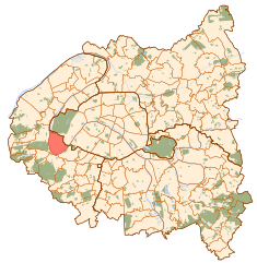
Saint-Cloud (Saint-Cloud)

- commune in Hauts-de-Seine, France
- Country:

- Postal Code: 92210
- Coordinates: 48° 50' 47" N, 2° 12' 55" E


- GPS tracks (wikiloc): [Link]
- AboveSeaLevel: 136 м m
- Area: 7.56 sq km
- Population: 29362
- Web site: http://www.saintcloud.fr
- Wikipedia en: wiki(en)
- Wikipedia: wiki(fr)
- Wikidata storage: Wikidata: Q189153
- Wikipedia Commons Category: [Link]
- Freebase ID: [/m/021y9q]
- Freebase ID: [/m/021y9q]
- GeoNames ID: Alt: [2981041]
- GeoNames ID: Alt: [2981041]
- SIREN number: [219200649]
- SIREN number: [219200649]
- BnF ID: [15280273m]
- BnF ID: [15280273m]
- VIAF ID: Alt: [133659547]
- VIAF ID: Alt: [133659547]
- OSM relation ID: [72148]
- OSM relation ID: [72148]
- GND ID: Alt: [4118232-7]
- GND ID: Alt: [4118232-7]
- archINFORM location ID: [3722]
- archINFORM location ID: [3722]
- Library of Congress authority ID: Alt: [n50058905]
- Library of Congress authority ID: Alt: [n50058905]
- MusicBrainz area ID: [f1674314-499b-4fd0-85ac-d1f2853b3a67]
- MusicBrainz area ID: [f1674314-499b-4fd0-85ac-d1f2853b3a67]
- Quora topic ID: [Saint-Cloud]
- Quora topic ID: [Saint-Cloud]
- EMLO location ID: [0a2ba8c3-15b7-4cf1-aef5-696543353a4b]
- EMLO location ID: [0a2ba8c3-15b7-4cf1-aef5-696543353a4b]
- Twitter username: Alt: [VilleSaintCloud]
- Twitter username: Alt: [VilleSaintCloud]
- INSEE municipality code: 92064
- INSEE municipality code: 92064
- US National Archives Identifier: 10045080
- US National Archives Identifier: 10045080
Shares border with regions:
Boulogne-Billancourt
- commune in Hauts-de-Seine, France
- Country:
- Postal Code: 92100
- Coordinates: 48° 50' 7" N, 2° 14' 29" E
- GPS tracks (wikiloc): [Link]
- AboveSeaLevel: 40 м m
- Area: 6.17 sq km
- Population: 117931
- Web site: [Link]

Rueil-Malmaison
- commune in Hauts-de-Seine, France
- Country:
- Postal Code: 92500
- Coordinates: 48° 52' 40" N, 2° 11' 18" E
- GPS tracks (wikiloc): [Link]
- Area: 14.7 sq km
- Population: 78794
- Web site: [Link]


Suresnes
- commune in Hauts-de-Seine, France
- Country:
- Postal Code: 92150
- Coordinates: 48° 52' 16" N, 2° 13' 37" E
- GPS tracks (wikiloc): [Link]
- AboveSeaLevel: 36 м m
- Area: 3.79 sq km
- Population: 48565
- Web site: [Link]

Sèvres
- Commune in Hauts-de-Seine, France
- Country:
- Postal Code: 92310
- Coordinates: 48° 49' 23" N, 2° 12' 39" E
- GPS tracks (wikiloc): [Link]
- AboveSeaLevel: 95 м m
- Area: 3.91 sq km
- Population: 23332
- Web site: [Link]


Garches
- commune in Hauts-de-Seine, France
- Country:
- Postal Code: 92380
- Coordinates: 48° 50' 44" N, 2° 11' 13" E
- GPS tracks (wikiloc): [Link]
- Area: 2.69 sq km
- Population: 17762
- Web site: [Link]


Ville-d'Avray
- commune in Hauts-de-Seine, France
- Country:
- Postal Code: 92410
- Coordinates: 48° 49' 34" N, 2° 11' 36" E
- GPS tracks (wikiloc): [Link]
- AboveSeaLevel: 125 м m
- Area: 3.67 sq km
- Population: 11422
- Web site: [Link]


Marnes-la-Coquette
- commune in Hauts-de-Seine, France
- Country:
- Postal Code: 92430
- Coordinates: 48° 49' 49" N, 2° 10' 38" E
- GPS tracks (wikiloc): [Link]
- Area: 3.48 sq km
- Population: 1751
- Web site: [Link]

Paris
- capital and largest city of France
- Country:
- Postal Code: 75020; 75019; 75018; 75017; 75016; 75015; 75014; 75013; 75012; 75011; 75010; 75009; 75008; 75007; 75006; 75005; 75004; 75003; 75002; 75001; 75116
- Local Dialing Code: 1
- Licence Plate Code: 75
- Coordinates: 48° 51' 24" N, 2° 21' 7" E
- GPS tracks (wikiloc): [Link]
- AboveSeaLevel: 28 м m
- Area: 105.4 sq km
- Population: 2206488
- Web site: [Link]