Villebarou (Villebarou)

- commune in Loir-et-Cher, France
- Country:

- Postal Code: 41000
- Coordinates: 47° 37' 21" N, 1° 19' 24" E


- GPS tracks (wikiloc): [Link]
- Area: 9.11 sq km
- Population: 2478
- Wikipedia en: wiki(en)
- Wikipedia: wiki(fr)
- Wikidata storage: Wikidata: Q1169872
- Wikipedia Commons Category: [Link]
- Freebase ID: [/m/03nw2zs]
- GeoNames ID: Alt: [6434156]
- SIREN number: [214102766]
- BnF ID: [15259550b]
- INSEE municipality code: 41276
Shares border with regions:


Saint-Sulpice-de-Pommeray
- commune in Loir-et-Cher, France
- Country:
- Postal Code: 41000
- Coordinates: 47° 36' 28" N, 1° 16' 9" E
- GPS tracks (wikiloc): [Link]
- Area: 11.5 sq km
- Population: 1869
Villerbon
- commune in Loir-et-Cher, France
- Country:
- Postal Code: 41000
- Coordinates: 47° 39' 44" N, 1° 22' 18" E
- GPS tracks (wikiloc): [Link]
- Area: 17.28 sq km
- Population: 793

Marolles
- commune in Loir-et-Cher, France
- Country:
- Postal Code: 41330
- Coordinates: 47° 38' 52" N, 1° 18' 25" E
- GPS tracks (wikiloc): [Link]
- Area: 9.88 sq km
- Population: 738
Fossé
- commune in Loir-et-Cher, France
- Country:
- Postal Code: 41330
- Coordinates: 47° 38' 0" N, 1° 17' 3" E
- GPS tracks (wikiloc): [Link]
- Area: 10.2 sq km
- Population: 1321
- Web site: [Link]


La Chaussée-Saint-Victor
- commune in Loir-et-Cher, France
- Country:
- Postal Code: 41260
- Coordinates: 47° 36' 50" N, 1° 21' 55" E
- GPS tracks (wikiloc): [Link]
- Area: 6.63 sq km
- Population: 4510
- Web site: [Link]
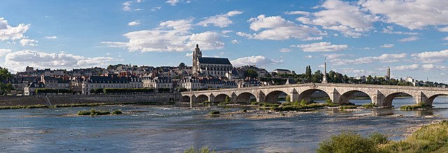
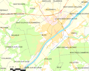
Blois
- commune in Loir-et-Cher, France
- Country:
- Postal Code: 41000
- Coordinates: 47° 35' 35" N, 1° 19' 38" E
- GPS tracks (wikiloc): [Link]
- AboveSeaLevel: 73 м m
- Area: 37.46 sq km
- Population: 45710
- Web site: [Link]


Saint-Denis-sur-Loire
- commune in Loir-et-Cher, France
- Country:
- Postal Code: 41000
- Coordinates: 47° 37' 30" N, 1° 23' 11" E
- GPS tracks (wikiloc): [Link]
- Area: 12.4 sq km
- Population: 838