Villeneuve-sur-Conie (Villeneuve-sur-Conie)

- commune in Loiret, France
- Country:

- Postal Code: 45310
- Coordinates: 48° 2' 41" N, 1° 39' 3" E


- GPS tracks (wikiloc): [Link]
- Area: 17.97 sq km
- Population: 211
- Wikipedia en: wiki(en)
- Wikipedia: wiki(fr)
- Wikidata storage: Wikidata: Q304348
- Wikipedia Commons Category: [Link]
- Freebase ID: [/m/03nwgyy]
- GeoNames ID: Alt: [6612559]
- SIREN number: [214503419]
- BnF ID: [15260733b]
- PACTOLS thesaurus ID: [pcrtjgS2h8LHWj]
- INSEE municipality code: 45341
Shares border with regions:


Péronville
- commune in Eure-et-Loir, France
- Country:
- Postal Code: 28140
- Coordinates: 48° 3' 46" N, 1° 35' 1" E
- GPS tracks (wikiloc): [Link]
- Area: 24.9 sq km
- Population: 264
La Chapelle-Onzerain
- commune in Loiret, France
- Country:
- Postal Code: 45310
- Coordinates: 48° 2' 0" N, 1° 36' 43" E
- GPS tracks (wikiloc): [Link]
- Area: 7.06 sq km
- Population: 122


Tournoisis
- commune in Loiret, France
- Country:
- Postal Code: 45310
- Coordinates: 48° 0' 20" N, 1° 37' 49" E
- GPS tracks (wikiloc): [Link]
- Area: 14.94 sq km
- Population: 408

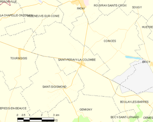
Saint-Péravy-la-Colombe
- commune in Loiret, France
- Country:
- Postal Code: 45310
- Coordinates: 48° 0' 1" N, 1° 41' 59" E
- GPS tracks (wikiloc): [Link]
- Area: 18.96 sq km
- Population: 742
- Web site: [Link]


Patay
- commune in Loiret, France
- Country:
- Postal Code: 45310
- Coordinates: 48° 2' 53" N, 1° 41' 44" E
- GPS tracks (wikiloc): [Link]
- Area: 13.8 sq km
- Population: 2133
- Web site: [Link]

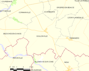
Guillonville
- commune in Eure-et-Loir, France
- Country:
- Postal Code: 28140
- Coordinates: 48° 5' 27" N, 1° 39' 44" E
- GPS tracks (wikiloc): [Link]
- AboveSeaLevel: 136 м m
- Area: 27.15 sq km
- Population: 442
- Web site: [Link]