Villers-en-Argonne (Villers-en-Argonne)

- commune in Marne, France
- Country:

- Postal Code: 51800
- Coordinates: 49° 1' 14" N, 4° 56' 4" E


- GPS tracks (wikiloc): [Link]
- Area: 9.57 sq km
- Population: 231
- Wikipedia en: wiki(en)
- Wikipedia: wiki(fr)
- Wikidata storage: Wikidata: Q635483
- Wikipedia Commons Category: [Link]
- Freebase ID: [/m/03qdc06]
- GeoNames ID: Alt: [6436091]
- SIREN number: [215105859]
- BnF ID: [15263221p]
- INSEE municipality code: 51632
Shares border with regions:


Beaulieu-en-Argonne
- commune in Meuse, France
- Country:
- Postal Code: 55250
- Coordinates: 49° 1' 54" N, 5° 4' 1" E
- GPS tracks (wikiloc): [Link]
- Area: 29.56 sq km
- Population: 37


Châtrices
- commune in Marne, France
- Country:
- Postal Code: 51800
- Coordinates: 49° 2' 18" N, 4° 56' 17" E
- GPS tracks (wikiloc): [Link]
- Area: 19.53 sq km
- Population: 34


Sivry-Ante
- commune in Marne, France
- Country:
- Postal Code: 51800
- Coordinates: 49° 0' 0" N, 4° 52' 8" E
- GPS tracks (wikiloc): [Link]
- AboveSeaLevel: 153 м m
- Area: 21.6 sq km
- Population: 180

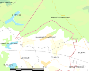
Passavant-en-Argonne
- commune in Marne, France
- Country:
- Postal Code: 51800
- Coordinates: 49° 1' 24" N, 5° 0' 17" E
- GPS tracks (wikiloc): [Link]
- Area: 7.24 sq km
- Population: 212
Le Chemin
- commune in Marne, France
- Country:
- Postal Code: 51800
- Coordinates: 49° 0' 17" N, 4° 58' 14" E
- GPS tracks (wikiloc): [Link]
- Area: 6.24 sq km
- Population: 53