Villers-le-Lac (Villers-le-Lac)

- commune in Doubs, France
 Hiking in Villers-le-Lac
Villers-le-Lac is a charming village located in the Doubs department in the Franche-Comté region of eastern France. It's an ideal base for hiking enthusiasts due to its stunning natural surroundings, including the Jura Mountains and proximity to the Swiss border.
Hiking Highlights:
-
Scenic Trails: The area features a variety of well-marked trails that cater to different skill levels. Whether you're a beginner or an experienced hiker, you can find trails that suit your abilities. Some routes offer breathtaking views of the Doubs Valley and the surrounding mountains.
-
Regional Natural Parks: Villers-le-Lac is near the Parc Naturel Régional du Doubs, where hikers can explore diverse landscapes, including forests, rivers, and picturesque cliffs. This park is a wonderful spot for nature enthusiasts, with opportunities to see various wildlife.
-
Waterfalls and Lakes: One of the highlights of hiking in this region includes visiting beautiful waterfalls, such as the Saut du Doubs, and serene lakes. These locations are often accessible via hiking trails and make for great picnic spots.
-
The GR5 Trail: This long-distance trail runs through the region, part of a European hiking route that goes from the North Sea to the Mediterranean. Portions of the GR5 through the area provide challenging but rewarding hikes.
What to Bring:
- Proper Footwear: Good hiking boots are essential for comfort and ankle support.
- Weather Gear: The weather can change quickly, so it's wise to bring a waterproof jacket and layers.
- Hydration: Always carry enough water, especially on longer hikes.
- Navigation Tools: A map or GPS device is helpful to stay on track.
- Snacks: Energy bars or trail mix can keep you energized during your trek.
When to Visit:
Spring and autumn are particularly beautiful times to hike in Villers-le-Lac, with mild weather and stunning fall foliage. Summer can also be enjoyable, but be prepared for the occasional rain shower.
Whether you’re looking for a short day hike or a more challenging multi-day trek, Villers-le-Lac serves as a fantastic entry point to explore the natural beauty of this enchanting region. Enjoy your hiking adventures!
- Country:

- Postal Code: 25130
- Coordinates: 47° 3' 39" N, 6° 40' 13" E


- GPS tracks (wikiloc): [Link]
- Area: 30.17 sq km
- Population: 4819
- Web site: http://www.villers-le-lac.fr
- Wikipedia en: wiki(en)
- Wikipedia: wiki(fr)
- Wikidata storage: Wikidata: Q838437
- Wikipedia Commons Category: [Link]
- Freebase ID: [/m/03mhffl]
- GeoNames ID: Alt: [6429835]
- SIREN number: [212503213]
- BnF ID: [15252547r]
- VIAF ID: Alt: [236924541]
- OSM relation ID: [142094]
- PACTOLS thesaurus ID: [pcrtFdTmNZA9tl]
- INSEE municipality code: 25321
Shares border with regions:


Montlebon
- commune in Doubs, France
Hiking in Montlebon
Montlebon, situated in the Doubs region of eastern France, offers picturesque landscapes ideal for hiking. Nestled in the Jura Mountains, it is surrounded by lush forests, rolling hills, and stunning viewpoints. Here are some highlights of hiking in Montlebon:...
- Country:
- Postal Code: 25500
- Coordinates: 47° 2' 30" N, 6° 36' 27" E
- GPS tracks (wikiloc): [Link]
- Area: 27.27 sq km
- Population: 2024


Le Locle
- municipality in Switzerland
Hiking in Le Locle
Le Locle is a charming town located in the Neuchâtel region of Switzerland, surrounded by beautiful landscapes and rolling hills, making it a great destination for hiking enthusiasts. Here are some key points about hiking in Le Locle:...
- Country:

- Postal Code: 2400
- Local Dialing Code: 032
- Licence Plate Code: NE
- Coordinates: 47° 3' 11" N, 6° 44' 53" E
- GPS tracks (wikiloc): [Link]
- AboveSeaLevel: 971 м m
- Area: 23.14 sq km
- Population: 10433
- Web site: [Link]


Noël-Cerneux
- commune in Doubs, France
Hiking in Noël-Cerneux
Noël-Cerneux is a picturesque commune located in the Doubs department of the Bourgogne-Franche-Comté region in eastern France. Known for its stunning natural beauty, it offers a range of outdoor activities, including hiking....
- Country:
- Postal Code: 25500
- Coordinates: 47° 6' 5" N, 6° 39' 49" E
- GPS tracks (wikiloc): [Link]
- Area: 6.36 sq km
- Population: 409
Les Planchettes
- municipality in Switzerland
Hiking in Les Planchettes
Les Planchettes, a picturesque area in the French Alps, offers wonderful hiking opportunities for outdoor enthusiasts. Situated near the village of Sixt-Fer-à-Cheval, it’s known for its stunning landscapes, including dramatic mountain scenery, lush meadows, and waterfalls. Here’s what you can expect when hiking in this region:...
- Country:
- Postal Code: 2325
- Local Dialing Code: 032
- Licence Plate Code: NE
- Coordinates: 47° 6' 30" N, 6° 46' 17" E
- GPS tracks (wikiloc): [Link]
- AboveSeaLevel: 1038 м m
- Area: 11.73 sq km
- Population: 205
- Web site: [Link]


Les Brenets
- municipality in Switzerland
Hiking in Les Brenets
Les Brenets is a picturesque village located in the Swiss canton of Neuchâtel, nestled in the Jura Mountains near the border with France. It's well-known for its stunning natural beauty, particularly its proximity to the Doubs River and the surrounding forested landscapes. Hiking in this area offers a variety of trails suitable for different skill levels, along with breathtaking views and rich biodiversity....
- Country:
- Postal Code: 2416
- Local Dialing Code: 032
- Licence Plate Code: NE
- Coordinates: 47° 4' 29" N, 6° 43' 29" E
- GPS tracks (wikiloc): [Link]
- AboveSeaLevel: 1068 м m
- Area: 11.53 sq km
- Population: 1048
- Web site: [Link]
Le Cerneux-Péquignot
- municipality in Switzerland
Hiking in Le Cerneux-Péquignot
Le Cerneux-Péquignot is a picturesque village located in the Jura Mountains of Switzerland, which offers an inviting landscape for hiking enthusiasts. The region is known for its natural beauty, featuring rolling hills, dense forests, and panoramic views of the surrounding mountains. Here are some highlights for hiking in and around Le Cerneux-Péquignot:...
- Country:
- Postal Code: 2414
- Local Dialing Code: 032
- Licence Plate Code: NE
- Coordinates: 47° 0' 57" N, 6° 40' 10" E
- GPS tracks (wikiloc): [Link]
- AboveSeaLevel: 1084 м m
- Area: 15.67 sq km
- Population: 317
- Web site: [Link]


Le Barboux
- commune in Doubs, France
Hiking in Le Barboux
Le Barboux is a charming village located in the Auvergne-Rhône-Alpes region of France, known for its beautiful natural scenery and outdoor activities, including hiking. The area is characterized by rolling hills, forests, and stunning views of the surrounding mountains, making it an ideal destination for hikers of all levels....
- Country:
- Postal Code: 25210
- Coordinates: 47° 7' 14" N, 6° 43' 1" E
- GPS tracks (wikiloc): [Link]
- Area: 11.26 sq km
- Population: 251

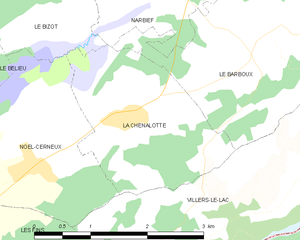
La Chenalotte
- commune in Doubs, France
Hiking in La Chenalotte
La Chenalotte is a beautiful area known for its stunning landscapes and diverse hiking trails, perfect for both beginners and experienced hikers. Located in the heart of nature, the region offers a variety of terrains, including lush forests, rocky paths, and picturesque viewpoints....
- Country:
- Postal Code: 25500
- Coordinates: 47° 6' 31" N, 6° 41' 3" E
- GPS tracks (wikiloc): [Link]
- Area: 4.88 sq km
- Population: 476
- Web site: [Link]
Grand'Combe-des-Bois
- commune in Doubs, France
Hiking in Grand'Combe-des-Bois
Grand'Combe-des-Bois, located in the Doubs department in the Bourgogne-Franche-Comté region of eastern France, offers a picturesque setting for hiking enthusiasts. Known for its stunning natural landscapes, the area features rolling hills, dense forests, and a variety of wildlife, making it ideal for outdoor activities....
- Country:
- Postal Code: 25210
- Coordinates: 47° 8' 16" N, 6° 47' 27" E
- GPS tracks (wikiloc): [Link]
- Area: 11.87 sq km
- Population: 137


Les Fins
- commune in Doubs, France
Hiking in Les Fins
Les Fins is a charming village located in the Doubs department of the Bourgogne-Franche-Comté region in eastern France, near the Swiss border. The area is known for its beautiful natural landscapes, rolling hills, and rich flora and fauna, making it a great destination for hiking enthusiasts....
- Country:
- Postal Code: 25500
- Coordinates: 47° 4' 51" N, 6° 37' 42" E
- GPS tracks (wikiloc): [Link]
- Area: 25.39 sq km
- Population: 3055