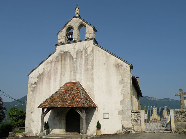
Virignin (Virignin)
- commune in Ain, France
Virignin, located in the Auvergne-Rhône-Alpes region of France, is surrounded by beautiful landscapes that offer various hiking opportunities. The area is not as well-known as some other hiking destinations in France, making it a serene choice for outdoor enthusiasts.
Hiking Opportunities
-
Scenic Views: The region is characterized by rolling hills, forests, and scenic vistas of the surrounding countryside and the nearby Lake Bourget, one of France's largest natural lakes.
-
Trails: There are several marked trails in and around Virignin, ranging from easy walks suitable for families to more challenging hikes for experienced trekkers. The Grand Site de la Chartreuse nearby offers well-maintained trails and stunning views.
-
Flora and Fauna: While hiking, you can enjoy diverse ecosystems, including woodlands, meadows, and wetlands. The local wildlife includes various bird species and small mammals, making it a great spot for nature lovers.
-
Cultural Sites: Along the hiking trails, you may encounter historical landmarks, old churches, and charming villages, allowing hikers to enjoy both nature and culture.
Tips for Hiking in Virignin
- Best Time to Hike: Spring (April to June) and fall (September to October) are great times to explore the area, with mild temperatures and beautiful scenery.
- Gear Up: Depending on the trails you choose, ensure you have appropriate footwear and clothing. Hiking boots are recommended, and it's wise to bring layers in case of changing weather.
- Stay Hydrated and Fed: Carry enough water and snacks, especially for longer hikes. There may not be many services along the trails.
- Respect Nature: Stay on marked trails to protect the local environment, and be mindful of wildlife.
Additional Activities
In addition to hiking, the region offers opportunities for cycling, bird watching, and photography, making it a well-rounded outdoor destination.
If you're planning a hike around Virignin, it would be wise to check local tourism websites or contact local guides for updated trail maps and conditions. Happy hiking!
- Country:

- Postal Code: 01300
- Coordinates: 45° 43' 2" N, 5° 42' 47" E


- GPS tracks (wikiloc): [Link]
- Area: 7.88 sq km
- Population: 1064
- Web site: http://www.virignin.fr
- Wikipedia en: wiki(en)
- Wikipedia: wiki(fr)
- Wikidata storage: Wikidata: Q744275
- Wikipedia Commons Category: [Link]
- Wikipedia Commons Maps Category: [Link]
- Freebase ID: [/m/0826yf]
- Freebase ID: [/m/0826yf]
- GeoNames ID: Alt: [6424739]
- GeoNames ID: Alt: [6424739]
- SIREN number: [210104543]
- SIREN number: [210104543]
- PACTOLS thesaurus ID: [pcrtqUbdbDiVw0]
- PACTOLS thesaurus ID: [pcrtqUbdbDiVw0]
- INSEE municipality code: 01454
- INSEE municipality code: 01454
Shares border with regions:


La Balme
- commune in Savoie, France
La Balme is a beautiful destination for hiking enthusiasts located in the French Alps. Here are some key highlights and considerations for hiking in La Balme:...
- Country:

- Postal Code: 73170
- Coordinates: 45° 42' 22" N, 5° 43' 7" E


- GPS tracks (wikiloc): [Link]
- Area: 9.4 sq km
- Population: 298

Belley
- commune in Ain, France
Belley, located in the Auvergne-Rhône-Alpes region of France, is surrounded by beautiful landscapes that offer a variety of hiking opportunities. The area is particularly known for its stunning natural scenery, including rolling hills, vineyards, and the nearby mountains of the Bauges and Chartreuse ranges....
- Country:

- Postal Code: 01300
- Coordinates: 45° 45' 33" N, 5° 41' 17" E


- GPS tracks (wikiloc): [Link]
- Area: 22.42 sq km
- Population: 9058
- Web site: [Link]

Brens
- commune in Ain, France
Brens, located in the Ain department of the Auvergne-Rhône-Alpes region in France, offers a beautiful setting for hiking enthusiasts. The area is characterized by its picturesque landscapes, rolling hills, and lush greenery, making it a great destination for outdoor activities....
- Country:

- Postal Code: 01300
- Coordinates: 45° 43' 7" N, 5° 41' 41" E


- GPS tracks (wikiloc): [Link]
- Area: 6.9 sq km
- Population: 1171
- Web site: [Link]

Parves et Nattages
- commune in Ain, France
Parves-et-Nattages is a charming commune in the Auvergne-Rhône-Alpes region of France, known for its beautiful natural landscapes that appeal to hikers. Here’s what you need to know about hiking in this area:...
- Country:

- Postal Code: 01300
- Coordinates: 45° 44' 38" N, 5° 44' 32" E


- GPS tracks (wikiloc): [Link]
- Area: 15.86 sq km
- Web site: [Link]


Yenne
- commune in Savoie, France
Yenne, located in the Savoie region of France, offers some delightful hiking opportunities, particularly because of its picturesque landscapes that include valleys, rivers, and mountains. The nearby Chartreuse and Bauges mountains provide various trails ranging from easy to challenging levels, suitable for hikers of all experiences....
- Country:

- Postal Code: 73170
- Coordinates: 45° 42' 15" N, 5° 45' 32" E


- GPS tracks (wikiloc): [Link]
- Area: 23.36 sq km
- Population: 2981
- Web site: [Link]


Parves
- former commune in Ain, France
Parves, located in the Auvergne-Rhône-Alpes region of France, is a beautiful destination for hiking enthusiasts. The area is characterized by its stunning landscapes, which include lush forests, mountainous terrain, and picturesque valleys. Here are some highlights and tips for hiking in Parves:...
- Country:

- Postal Code: 01300
- Coordinates: 45° 44' 39" N, 5° 44' 27" E


- GPS tracks (wikiloc): [Link]
- Area: 5.53 sq km
- Population: 371

Nattages
- former commune in Ain, France
Nattages, nestled in the breathtaking landscapes, offers a fantastic setting for hiking enthusiasts. While detailed information about specific trails may vary since my last update, here's an overall guide for hiking in this region....
- Country:

- Postal Code: 01300
- Coordinates: 45° 43' 41" N, 5° 45' 26" E


- GPS tracks (wikiloc): [Link]
- Area: 10.33 sq km
- Population: 567
