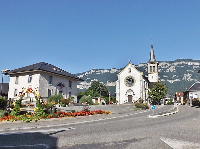
Voglans (Voglans)

- commune in Savoie, France
 Hiking in Voglans
Voglans, located in the Savoie department in the Auvergne-Rhône-Alpes region of southeastern France, offers beautiful hiking opportunities, mainly due to its proximity to the majestic Bauges Massif and Lake Bourget. The region is characterized by stunning landscapes, diverse flora and fauna, and a mix of terrains suitable for various levels of hikers.
Hiking Highlights in Voglans:
-
Lake Bourget: The largest natural lake in France, offers scenic routes along its shores. The paths around the lake provide easy, family-friendly hiking options, as well as opportunities for picnicking and enjoying views of the water and surrounding mountains.
-
Bauges Massif: This regional park provides a myriad of trails, from beginner to advanced levels. Here, you can find beautiful trails leading to panoramic viewpoints, as well as more challenging hikes that take you deeper into the mountainous terrain.
-
Flora and Fauna: The area is rich in biodiversity, and hikers can encounter numerous species of plants and animals, making it a great place for nature enthusiasts. Keep an eye out for local wildlife, especially in the protected areas.
-
Cultural Heritage: Voglans isn’t just about nature; it also offers cultural hikes where visitors can explore traditional Alpine villages, discover local history, and enjoy regional cuisine in quaint eateries along the trails.
-
Seasonal Hiking: Each season presents a different hiking experience. In spring and summer, enjoy lush greenery and wildflowers. Fall brings vibrant autumn colors, while winter hikes can lead to snow-covered landscapes, especially in higher elevations, with opportunities for snowshoeing and winter walking.
Tips for Hiking in Voglans:
- Trail Maps: It's advisable to pick up maps or download hiking apps that cover the area to help with navigation.
- Proper Gear: Ensure you wear appropriate hiking boots, carry water, snacks, and a first aid kit. Depending on the season, you may need additional gear.
- Weather Awareness: The weather can change rapidly in mountainous regions, so be prepared for sudden changes.
- Respect Nature: Follow the Leave No Trace principles to help preserve the beautiful environment for future generations.
Recommended Trails:
- The Tour du Lac de Bourget is a popular walk that offers fantastic lake views.
- Explore trails in the Bauges National Park for a more rugged experience, including the Col de la Charbonnière that provides stunning vistas.
Make sure to plan your route and check local resources for trail conditions, as they can vary. Enjoy your hiking adventures in Voglans!
- Country:

- Postal Code: 73420
- Coordinates: 45° 37' 57" N, 5° 53' 45" E


- GPS tracks (wikiloc): [Link]
- Area: 4.62 sq km
- Population: 1852
- Web site: http://www.mairie-voglans.fr
- Wikipedia en: wiki(en)
- Wikipedia: wiki(fr)
- Wikidata storage: Wikidata: Q819052
- Wikipedia Commons Category: [Link]
- Freebase ID: [/m/03npgtf]
- GeoNames ID: Alt: [6442935]
- SIREN number: [217303296]
- BnF ID: [15274259t]
- INSEE municipality code: 73329
Shares border with regions:


Chambéry
- commune in Savoie, France
Hiking in Chambéry
Chambéry, located in the Auvergne-Rhône-Alpes region of France, is surrounded by stunning mountains and beautiful landscapes, making it an excellent destination for hiking enthusiasts. Here are some highlights about hiking in the area:...
- Country:
- Postal Code: 73000
- Coordinates: 45° 33' 59" N, 5° 55' 15" E
- GPS tracks (wikiloc): [Link]
- AboveSeaLevel: 270 м m
- Area: 20.99 sq km
- Population: 59697
- Web site: [Link]


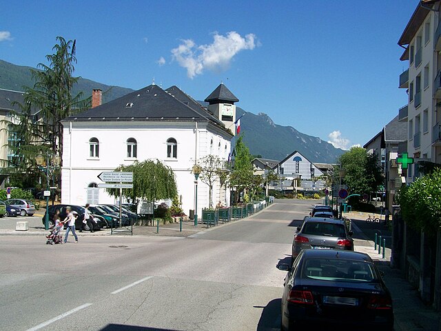
Le Bourget-du-Lac
- commune in Savoie, France
Hiking in Le Bourget-du-Lac
Le Bourget-du-Lac is a picturesque commune located in the Savoie department of the Auvergne-Rhône-Alpes region in southeastern France. It is situated on the shores of Lake Bourget, which is the largest natural lake in France. The area is known for its stunning natural landscapes, making it a great destination for hiking enthusiasts. Here are some highlights for hiking in and around Le Bourget-du-Lac:...
- Country:
- Postal Code: 73370
- Coordinates: 45° 38' 54" N, 5° 51' 35" E
- GPS tracks (wikiloc): [Link]
- Area: 20.05 sq km
- Population: 4570
- Web site: [Link]
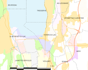
Viviers-du-Lac
- commune in Savoie, France
Hiking in Viviers-du-Lac
Viviers-du-Lac is a charming commune located in the Savoie department of France, near the shores of Lake Bourget, the largest natural lake in France. The area offers a variety of hiking opportunities that cater to different skill levels, making it an excellent destination for outdoor enthusiasts....
- Country:
- Postal Code: 73420
- Coordinates: 45° 38' 53" N, 5° 54' 21" E
- GPS tracks (wikiloc): [Link]
- Area: 3.94 sq km
- Population: 2203
- Web site: [Link]


Sonnaz
- commune in Savoie, France
Hiking in Sonnaz
Sonnaz, a charming village in the Auvergne-Rhône-Alpes region of France, offers a variety of hiking opportunities that showcase its natural beauty and scenic landscapes. Here are some key points to consider when planning your hiking adventures in and around Sonnaz:...
- Country:
- Postal Code: 73000
- Coordinates: 45° 37' 3" N, 5° 54' 52" E
- GPS tracks (wikiloc): [Link]
- Area: 6.79 sq km
- Population: 1795
- Web site: [Link]

La Motte-Servolex
- commune in Savoie, France
Hiking in La Motte-Servolex
La Motte-Servolex is a charming commune located in the Savoie department in the Auvergne-Rhône-Alpes region of southeastern France. Nestled near the foothills of the Chartreuse Mountains and close to the city of Chambéry, it offers a variety of hiking opportunities for all skill levels....
- Country:
- Postal Code: 73290
- Coordinates: 45° 35' 48" N, 5° 52' 39" E
- GPS tracks (wikiloc): [Link]
- Area: 29.85 sq km
- Population: 11731
- Web site: [Link]