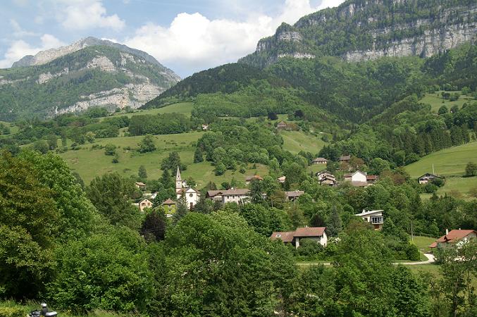
Voreppe (Voreppe)

- commune in Isère, France
 Hiking in Voreppe
Voreppe, located in the Isère department of southeastern France, is a picturesque area that offers various hiking opportunities amid stunning natural landscapes. The proximity to the Chartreuse and Vercors mountain ranges makes it an ideal base for outdoor enthusiasts.
Highlights of Hiking in Voreppe:
-
Scenic Trails: The region has a variety of trails catering to different skill levels. You can find easy paths suitable for families as well as more challenging routes for experienced hikers.
-
Natural Beauty: Hikers can enjoy beautiful views of the surrounding mountains, lush forests, and the Isère Valley. The flora and fauna in this area can be quite diverse, offering opportunities for wildlife observation.
-
Historic and Cultural Sites: Some trails may lead you to historical landmarks, such as ancient ruins or quaint villages, adding a cultural dimension to your hike.
-
Accessibility: Voreppe is relatively close to larger cities like Grenoble, providing easy access to trailheads and making it convenient for day trips.
-
Seasonal Hiking: Each season offers a different experience. In spring and summer, trails are lush and vibrant, while autumn provides beautiful foliage, and winter may offer opportunities for snowshoeing or winter hiking in nearby areas.
Tips for Hiking in Voreppe:
- Check Trail Maps: It’s essential to familiarize yourself with the trails and their difficulty levels. Local tourism offices often provide maps and advice on the best routes.
- Stay Hydrated: Bring enough water, especially during warmer months, as some trails might not have water sources along the way.
- Dress Appropriately: Wear appropriate hiking gear, including sturdy shoes, and consider the weather conditions as they can change rapidly in the mountains.
- Respect Nature: Follow Leave No Trace principles to minimize your impact on the environment.
Popular Nearby Hikes:
- Chartreuse Regional Nature Park: This area features numerous trails with varied landscapes and difficulty levels, offering ample opportunities for exploration.
- Vercors Regional Natural Park: Another beautiful area nearby known for its dramatic cliffs and unique geological formations.
Whether you’re looking for a leisurely walk or a challenging adventure, hiking in Voreppe offers something for everyone. Enjoy your outdoor experience!
- Country:

- Postal Code: 38340
- Coordinates: 45° 17' 52" N, 5° 38' 13" E


- GPS tracks (wikiloc): [Link]
- Area: 28.65 sq km
- Population: 9441
- Web site: https://www.voreppe.fr/
- Wikipedia en: wiki(en)
- Wikipedia: wiki(fr)
- Wikidata storage: Wikidata: Q752466
- Wikipedia Commons Category: [Link]
- Freebase ID: [/m/03nvjh3]
- GeoNames ID: Alt: [2967695]
- SIREN number: [213805658]
- BnF ID: [15258365k]
- VIAF ID: Alt: [151377841]
- GND ID: Alt: [4242202-4]
- Library of Congress authority ID: Alt: [n88150371]
- MusicBrainz area ID: [08526ad5-7561-4c68-89fa-ca0c538ad8e8]
- WOEID: [632623]
- INSEE municipality code: 38565
Shares border with regions:


Saint-Jean-de-Moirans
- commune in Isère, France
Hiking in Saint-Jean-de-Moirans
Saint-Jean-de-Moirans is located in the Auvergne-Rhône-Alpes region of France, nestled at the foot of the Chartreuse Mountains. This picturesque area offers a variety of hiking opportunities that cater to different skill levels, from leisurely walks to more challenging treks....
- Country:
- Postal Code: 38430
- Coordinates: 45° 20' 28" N, 5° 34' 56" E
- GPS tracks (wikiloc): [Link]
- Area: 6.43 sq km
- Population: 3427
- Web site: [Link]


Saint-Quentin-sur-Isère
- commune in Isère, France
Hiking in Saint-Quentin-sur-Isère
Saint-Quentin-sur-Isère, located in the Isère department of France, is surrounded by beautiful landscapes that are perfect for hiking enthusiasts. The region features a mix of rolling hills, forests, and views of the nearby Alps, making it a great destination for hiking....
- Country:
- Postal Code: 38210
- Coordinates: 45° 16' 45" N, 5° 32' 32" E
- GPS tracks (wikiloc): [Link]
- Area: 19.45 sq km
- Population: 1396
- Web site: [Link]

Pommiers-la-Placette
- former commune in Isère, France
Hiking in Pommiers-la-Placette
Pommiers-la-Placette is a charming village located in the picturesque Grenoble region of France, nestled in the heart of the French Alps. This area is known for its breathtaking landscapes, offering a plethora of hiking opportunities for outdoor enthusiasts of all skill levels....
- Country:
- Postal Code: 38340
- Coordinates: 45° 19' 3" N, 5° 39' 26" E
- GPS tracks (wikiloc): [Link]
- Area: 16.92 sq km
- Population: 554
- Web site: [Link]


Veurey-Voroize
- commune in Isère, France
Hiking in Veurey-Voroize
Veurey-Voroize is a charming commune located near Grenoble in the Auvergne-Rhône-Alpes region of France. It is surrounded by scenic landscapes and mountains, making it an attractive destination for hiking enthusiasts....
- Country:
- Postal Code: 38113
- Coordinates: 45° 16' 20" N, 5° 36' 52" E
- GPS tracks (wikiloc): [Link]
- Area: 12.21 sq km
- Population: 1444
- Web site: [Link]


La Buisse
- commune in Isère, France
Hiking in La Buisse
La Buisse is a charming village located in the Isère department of the Auvergne-Rhône-Alpes region in France. It serves as a great starting point for hiking enthusiasts looking to explore the natural beauty of the area, particularly the nearby Vercors Regional Natural Park and the Chartreuse Mountains....
- Country:
- Postal Code: 38500
- Coordinates: 45° 20' 6" N, 5° 37' 18" E
- GPS tracks (wikiloc): [Link]
- Area: 11.53 sq km
- Population: 3144
- Web site: [Link]

Noyarey
- commune in Isère, France
Hiking in Noyarey
Noyarey is a charming commune located in the Auvergne-Rhône-Alpes region of France, near the city of Saint-Egrève and the beautiful landscape of the Chartreuse Mountains. Hiking in Noyarey and its surrounding areas offers a variety of trails with stunning views of the mountains and valleys. Here are some key points to consider when hiking in Noyarey:...
- Country:
- Postal Code: 38360
- Coordinates: 45° 14' 37" N, 5° 37' 53" E
- GPS tracks (wikiloc): [Link]
- Area: 16.86 sq km
- Population: 2257
- Web site: [Link]


Moirans
- commune in Isère, France
Hiking in Moirans
Moirans, located in the Auvergne-Rhône-Alpes region of France, is surrounded by beautiful landscapes that are perfect for hiking enthusiasts. Here are some key points to consider if you're planning a hiking trip in this area:...
- Country:
- Postal Code: 38430
- Coordinates: 45° 19' 30" N, 5° 33' 52" E
- GPS tracks (wikiloc): [Link]
- Area: 20.06 sq km
- Population: 8022
- Web site: [Link]


Mont-Saint-Martin
- commune in Isère, France
Hiking in Mont-Saint-Martin
Mont-Saint-Martin, located in the Isère department of the Auvergne-Rhône-Alpes region in southeastern France, offers a variety of hiking opportunities that showcase the beautiful landscapes and natural features of the Alps. Here are some highlights and tips for hiking in the area:...
- Country:
- Postal Code: 38120
- Coordinates: 45° 16' 17" N, 5° 40' 31" E
- GPS tracks (wikiloc): [Link]
- Area: 5.31 sq km
- Population: 80


Fontanil-Cornillon
- commune in Isère, France
Hiking in Fontanil-Cornillon
Fontanil-Cornillon, located near Grenoble in the Auvergne-Rhône-Alpes region of France, offers a variety of hiking opportunities for outdoor enthusiasts. The area is characterized by its beautiful landscapes, charming villages, and proximity to the Chartreuse Mountains and the Vercors Regional Natural Park....
- Country:
- Postal Code: 38120
- Coordinates: 45° 15' 20" N, 5° 39' 55" E
- GPS tracks (wikiloc): [Link]
- Area: 5.5 sq km
- Population: 2735
- Web site: [Link]