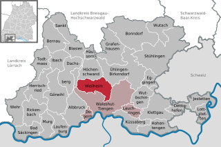
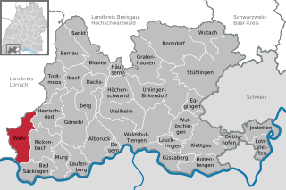
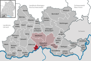
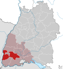
Waldshut (Landkreis Waldshut)


- district of Baden-Württemberg, Germany
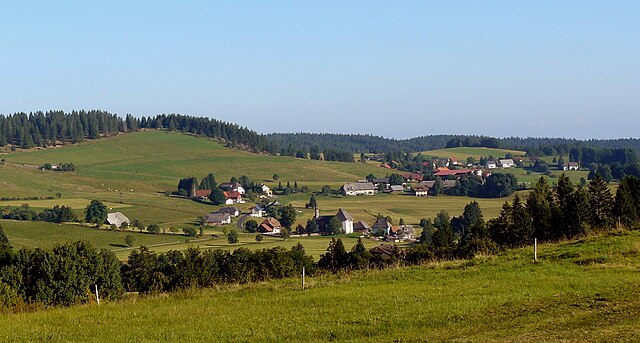
 Hiking in Waldshut
Waldshut is a beautiful district in the state of Baden-Württemberg, Germany, known for its stunning natural landscapes, which make it an excellent destination for hikers. The district is situated near the borders of Switzerland and provides a variety of hiking opportunities suitable for different skill levels. Here are some highlights and suggestions for hiking in Waldshut:
1.
- Southern Black Forest: Waldshut is located at the northern edge of the Southern Black Forest, offering numerous well-marked hiking trails. The region boasts lush forests, rolling hills, and picturesque views.
- Dinkelberg Ridge: This ridge offers a series of gentle to moderate hiking trails with panoramic views of the Rhine Valley and the Alps on a clear day.
2.
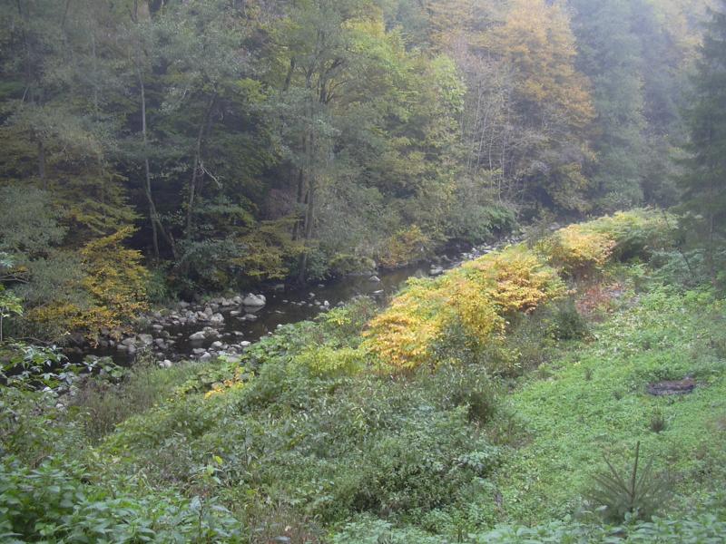
- The Wutach Gorge: One of the most renowned hiking spots in the area, this trail takes you through a stunning gorge with impressive rock formations, waterfalls, and diverse flora and fauna. It is a moderate hike that provides stunning views and a chance to explore nature.
- The "Höhenweg" Trail: This high altitude trail meanders along the ridge of the Black Forest, providing beautiful views and a peaceful hiking experience.
3.
- Many trails pass through charming villages, where hikers can experience local culture and traditions. Traditional Black Forest cuisine can be enjoyed at various inns and restaurants along the way.
4.
- Spring and Summer: These seasons offer the best hiking conditions, with blooming wildflowers and lush greenery. Trails are generally well-maintained and accessible.
- Autumn: Fall hiking provides an opportunity to see beautiful foliage as the leaves change colors. Cooler temperatures are ideal for longer hikes.
- Winter: Some trails may be less accessible depending on snow conditions, but winter hiking can also be beautiful, especially with snow-covered landscapes.
5.
- Preparation: Always check the weather and trail conditions before heading out. Carry enough water, snacks, and wear appropriate footwear.
- Local Maps: It's advisable to have a hiking map of the area since not all trails may be well-signposted.
- Safety: Always inform someone about your hiking plans, especially for longer hikes.
6.
- There are trails suitable for families and those with mobility challenges, so everyone can enjoy the natural beauty of the area.
For an enriching hiking experience, consider combining physical activity with explorations of the local culture and history found throughout the Waldshut district. Enjoy your adventure!
- Country:

- Capital: Waldshut-Tiengen
- Licence Plate Code: WT
- Coordinates: 47° 37' 48" N, 8° 12' 0" E


- GPS tracks (wikiloc): [Link]
- AboveSeaLevel: 729 м m
- Area: 1131.19 sq km
- Population: 163699
- Web site: http://www.landkreis-waldshut.de
- Wikipedia en: wiki(en)
- Wikipedia: wiki(de)
- Wikidata storage: Wikidata: Q8200
- Wikipedia Commons Category: [Link]
- Freebase ID: [/m/01ldp4]
- GeoNames ID: Alt: [3214112]
- VIAF ID: Alt: [312816297]
- OSM relation ID: [62716]
- GND ID: Alt: [4064418-2]
- archINFORM location ID: [2661]
- Library of Congress authority ID: Alt: [n84238905]
- TGN ID: [7075010]
- NUTS code: [DE13A]
- German district key: 08337
Includes regions:


St. Blasien
- municipality in Germany
Hiking in St. Blasien
Sankt Blasien is a charming town in the Black Forest region of Germany, known for its stunning natural beauty and outdoor activities, particularly hiking. The area offers a variety of trails that cater to different skill levels, from leisurely walks to more challenging hikes. Here are some highlights for hiking in Sankt Blasien:...
- Country:
- Postal Code: 79837
- Local Dialing Code: 07672
- Licence Plate Code: WT
- Coordinates: 47° 45' 43" N, 8° 7' 42" E
- GPS tracks (wikiloc): [Link]
- AboveSeaLevel: 770 м m
- Area: 54.36 sq km
- Population: 3923
- Web site: [Link]


Bonndorf im Schwarzwald
- town in the Waldshut district in Baden-Württemberg, Germany
Hiking in Bonndorf im Schwarzwald
Bonndorf, located in the Black Forest region of Germany, is a beautiful area for hiking enthusiasts. The region is characterized by lush forests, rolling hills, and picturesque landscapes, making it an ideal destination for both novice and experienced hikers....
- Country:
- Postal Code: 79848; 79844
- Local Dialing Code: 07703
- Licence Plate Code: WT
- Coordinates: 47° 49' 10" N, 8° 20' 35" E
- GPS tracks (wikiloc): [Link]
- AboveSeaLevel: 845 м m
- Area: 76.03 sq km
- Population: 6901
- Web site: [Link]


Eggingen
- municipality in Germany
Hiking in Eggingen
Eggingen, located in the scenic region of Germany, offers wonderful opportunities for hiking enthusiasts. Nestled in the rolling landscapes of the Swabian Jura, this area is known for its unique geology, lush forests, and beautiful trails. Here are some highlights for hiking in Eggingen:...
- Country:
- Postal Code: 79805
- Local Dialing Code: 07746
- Licence Plate Code: WT
- Coordinates: 47° 42' 0" N, 8° 24' 0" E
- GPS tracks (wikiloc): [Link]
- AboveSeaLevel: 434 м m
- Area: 13.95 sq km
- Population: 1671
- Web site: [Link]

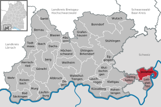
Jestetten
- municipality in Germany
Hiking in Jestetten
Jestetten is a charming village located in the Baden-Württemberg region of Germany, close to the Swiss border. It offers a variety of hiking opportunities that cater to different skill levels and interests. Here are some key highlights about hiking in and around Jestetten:...
- Country:
- Postal Code: 79798
- Local Dialing Code: 07745
- Licence Plate Code: WT
- Coordinates: 47° 39' 0" N, 8° 34' 0" E
- GPS tracks (wikiloc): [Link]
- AboveSeaLevel: 429 м m
- Area: 20.63 sq km
- Population: 5026
- Web site: [Link]


Hohentengen am Hochrhein
- municipality in Germany
Hiking in Hohentengen am Hochrhein
Hohentengen am Hochrhein is a picturesque town located in southern Germany, near the borders of Switzerland and France. It is situated along the Rhine River, providing a scenic backdrop for various outdoor activities, including hiking. Here are some highlights about hiking in and around Hohentengen:...
- Country:
- Postal Code: 79801
- Local Dialing Code: 07742
- Licence Plate Code: WT
- Coordinates: 47° 34' 12" N, 8° 26' 2" E
- GPS tracks (wikiloc): [Link]
- AboveSeaLevel: 368 м m
- Area: 27.55 sq km
- Population: 3673
- Web site: [Link]

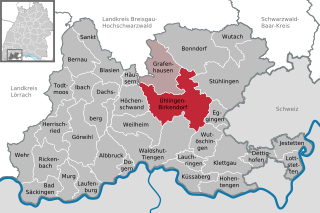
Ühlingen-Birkendorf
- municipality in Germany
Hiking in Ühlingen-Birkendorf
Ühlingen-Birkendorf is a quaint village located in the southern part of Germany, nestled in the picturesque area of the Black Forest, near the border with Switzerland. This region is known for its stunning landscapes, dense forests, and a variety of hiking trails suitable for all skill levels....
- Country:
- Postal Code: 79777
- Local Dialing Code: 07747; 07743
- Licence Plate Code: WT
- Coordinates: 47° 43' 0" N, 8° 19' 0" E
- GPS tracks (wikiloc): [Link]
- AboveSeaLevel: 644 м m
- Area: 77.07 sq km
- Population: 5137
- Web site: [Link]

Görwihl
- municipality in Germany
Hiking in Görwihl
Görwihl is a picturesque village located in the southern Black Forest region of Germany, known for its beautiful landscapes and outdoor activities. Hiking in this area can be a delightful experience for both beginners and experienced hikers. Here are some highlights and recommendations for hiking in Görwihl:...
- Country:
- Postal Code: 79733
- Local Dialing Code: 07754
- Licence Plate Code: WT
- Coordinates: 47° 39' 0" N, 8° 5' 0" E
- GPS tracks (wikiloc): [Link]
- AboveSeaLevel: 612 м m
- Area: 50.42 sq km
- Population: 4236
- Web site: [Link]

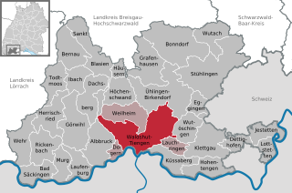
Waldshut-Tiengen
- municipality in Germany
Hiking in Waldshut-Tiengen
Waldshut-Tiengen is a picturesque region in Germany, located in the southern state of Baden-Württemberg, near the border with Switzerland. The area offers a variety of hiking opportunities that cater to all levels, from leisurely walks to more challenging hikes. Here are some key aspects of hiking in Waldshut-Tiengen:...
- Country:
- Postal Code: 79741–79761
- Local Dialing Code: 07751; 07741
- Licence Plate Code: WT
- Coordinates: 47° 37' 23" N, 8° 12' 52" E
- GPS tracks (wikiloc): [Link]
- AboveSeaLevel: 341 м m
- Area: 77.98 sq km
- Population: 24149
- Web site: [Link]


Todtmoos
- municipality in Germany
Hiking in Todtmoos
Todtmoos is a charming village located in the Black Forest region of Germany. It's known for its stunning natural landscapes, fresh air, and a network of beautiful hiking trails that cater to all levels of hikers, from beginners to experienced adventurers. Here’s an overview of what you can expect when hiking in Todtmoos:...
- Country:
- Postal Code: 79682
- Local Dialing Code: 07674
- Licence Plate Code: WT
- Coordinates: 47° 44' 22" N, 8° 0' 3" E
- GPS tracks (wikiloc): [Link]
- AboveSeaLevel: 820 м m
- Area: 28.09 sq km
- Population: 1852
- Web site: [Link]

Weilheim
- municipality in Germany
Hiking in Weilheim
Weilheim, a charming town in the Baden-Württemberg region of Germany, offers a variety of hiking opportunities that showcase the natural beauty of the Swabian Alps. The surrounding landscapes are characterized by rolling hills, dense forests, and scenic vistas, making it an attractive destination for outdoor enthusiasts....
- Country:
- Postal Code: 79809
- Local Dialing Code: 07741
- Licence Plate Code: WT
- Coordinates: 47° 39' 30" N, 8° 14' 26" E
- GPS tracks (wikiloc): [Link]
- AboveSeaLevel: 517 м m
- Area: 35.64 sq km
- Population: 3085
- Web site: [Link]

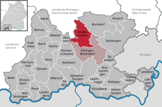
Grafenhausen
- municipality in the district of Waldshut, Germany
Hiking in Grafenhausen
Grafenhausen, located in the beautiful region of Southern Germany near the Black Forest, offers a wonderful setting for hiking enthusiasts of all levels. Here are some points to consider when hiking in this area:...
- Country:
- Postal Code: 79865
- Local Dialing Code: 07748
- Licence Plate Code: WT
- Coordinates: 47° 46' 0" N, 8° 16' 0" E
- GPS tracks (wikiloc): [Link]
- AboveSeaLevel: 926 м m
- Area: 48.54 sq km
- Population: 2246
- Web site: [Link]


Dettighofen
- municipality in Germany
Hiking in Dettighofen
Dettighofen is a charming village located in the district of Waldshut in Baden-Württemberg, Germany. While it might not be one of the most popular hiking destinations in Germany, it offers a variety of hiking opportunities in the picturesque landscapes of the surrounding Black Forest region....
- Country:
- Postal Code: 79802
- Local Dialing Code: 07742
- Licence Plate Code: WT
- Coordinates: 47° 37' 26" N, 8° 29' 1" E
- GPS tracks (wikiloc): [Link]
- AboveSeaLevel: 458 м m
- Area: 14.39 sq km
- Population: 1135
- Web site: [Link]


Höchenschwand
- municipality in Germany
Hiking in Höchenschwand
Höchenschwand is a charming village located in the Black Forest region of Germany, known for its beautiful landscapes, well-marked hiking trails, and tranquil atmosphere. Here’s what you can expect when hiking in Höchenschwand:...
- Country:
- Postal Code: 79862
- Local Dialing Code: 07755; 07672
- Licence Plate Code: WT
- Coordinates: 47° 44' 0" N, 8° 10' 0" E
- GPS tracks (wikiloc): [Link]
- AboveSeaLevel: 1008 м m
- Area: 29.55 sq km
- Population: 2498
- Web site: [Link]


Häusern
- municipality in Germany
Hiking in Häusern
Häusern is a charming village located in the scenic Black Forest region of Germany. It's a great spot for hiking enthusiasts, offering a variety of trails that cater to different skill levels. Here’s an overview of what you can expect when hiking in and around Häusern:...
- Country:
- Postal Code: 79837
- Local Dialing Code: 07672
- Licence Plate Code: WT
- Coordinates: 47° 45' 14" N, 8° 10' 10" E
- GPS tracks (wikiloc): [Link]
- AboveSeaLevel: 889 м m
- Area: 8.88 sq km
- Population: 1277
- Web site: [Link]


Dachsberg
- municipality in Germany
Hiking in Dachsberg
Dachsberg, located in the Black Forest region of Germany, is a fantastic destination for hiking enthusiasts. The area's scenic beauty, diverse trails, and rich natural landscapes make it an appealing choice for both novice and experienced hikers. Here’s what you should know about hiking in Dachsberg:...
- Country:
- Postal Code: 79837; 79875
- Local Dialing Code: 07755; 07672
- Licence Plate Code: WT
- Coordinates: 47° 43' 47" N, 8° 5' 56" E
- GPS tracks (wikiloc): [Link]
- AboveSeaLevel: 934 м m
- Area: 35.60 sq km
- Population: 1386
- Web site: [Link]


Wutach
- municipality in Germany
Hiking in Wutach
Wutach is a small village located in the southern part of Germany, specifically within the district of Waldshut in Baden-Württemberg. It is surrounded by beautiful landscapes that are ideal for hiking and outdoor activities. The area is characterized by its lush forests, hills, and the scenic Wutach Gorge, which is a highlight for many hikers....
- Country:
- Postal Code: 79879
- Local Dialing Code: 07709
- Licence Plate Code: WT
- Coordinates: 47° 50' 17" N, 8° 26' 40" E
- GPS tracks (wikiloc): [Link]
- AboveSeaLevel: 730 м m
- Area: 30.48 sq km
- Population: 1214
- Web site: [Link]


Lottstetten
- municipality in Germany
Hiking in Lottstetten
Lottstetten, a small municipality located in the southwestern part of Germany near the Swiss border, offers some beautiful hiking opportunities for outdoor enthusiasts. Here are some highlights and tips for hiking in and around Lottstetten:...
- Country:
- Postal Code: 79807
- Local Dialing Code: 07745
- Licence Plate Code: WT
- Coordinates: 47° 37' 44" N, 8° 34' 20" E
- GPS tracks (wikiloc): [Link]
- AboveSeaLevel: 433 м m
- Area: 13.39 sq km
- Population: 2253
- Web site: [Link]


Bad Säckingen
- municipality in Germany
Hiking in Bad Säckingen
Bad Säckingen, located in the southern part of Germany near the border with Switzerland, offers a variety of beautiful hiking opportunities, thanks to its picturesque landscapes along the Rhine River and the surrounding Black Forest region. Here are some key highlights and tips for hiking in this area:...
- Country:
- Postal Code: 79713
- Local Dialing Code: 07761
- Licence Plate Code: WT
- Coordinates: 47° 33' 12" N, 7° 56' 50" E
- GPS tracks (wikiloc): [Link]
- AboveSeaLevel: 291 м m
- Area: 25.34 sq km
- Population: 16416
- Web site: [Link]

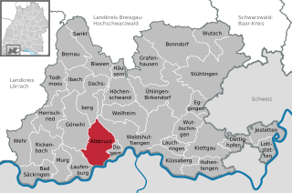
Albbruck
- municipality in Germany
Hiking in Albbruck
Albrück is a charming municipality located in the district of Waldshut in Baden-Württemberg, Germany, near the border with Switzerland. It is situated along the banks of the Rhine River and is surrounded by beautiful natural landscapes, making it an excellent destination for hiking enthusiasts....
- Country:
- Postal Code: 79774
- Local Dialing Code: 07753
- Licence Plate Code: WT
- Coordinates: 47° 35' 27" N, 8° 7' 46" E
- GPS tracks (wikiloc): [Link]
- AboveSeaLevel: 315 м m
- Area: 39.69 sq km
- Population: 7185
- Web site: [Link]


Stühlingen
- municipality in Germany
Hiking in Stühlingen
Stühlingen is a charming town located in the southern part of Germany, near the border with Switzerland. It's surrounded by beautiful landscapes, making it an excellent destination for hiking enthusiasts. Here are some key points to consider about hiking in and around Stühlingen:...
- Country:
- Postal Code: 79780
- Local Dialing Code: 07744; 07743; 07709; 07703
- Licence Plate Code: WT
- Coordinates: 47° 44' 43" N, 8° 26' 45" E
- GPS tracks (wikiloc): [Link]
- AboveSeaLevel: 501 м m
- Area: 93.22 sq km
- Population: 4956
- Web site: [Link]


Lauchringen
- municipality in Germany
Hiking in Lauchringen
Lauchringen is a small town located in the southern part of Germany, in the state of Baden-Württemberg, near the border with Switzerland. The region is characterized by beautiful landscapes, including rolling hills, forests, and scenic views of the Rhine Valley and the Swiss Alps in the distance....
- Country:
- Postal Code: 79787
- Local Dialing Code: 07741
- Licence Plate Code: WT
- Coordinates: 47° 37' 50" N, 8° 18' 16" E
- GPS tracks (wikiloc): [Link]
- AboveSeaLevel: 360 м m
- Area: 12.77 sq km
- Population: 7584
- Web site: [Link]
Wehr
- municipality in Germany
Hiking in Wehr
Wehr is a charming town located in the southern part of Germany's Baden-Württemberg region, nestled at the foot of the scenic Black Forest. The area is well-known for its picturesque landscapes and numerous hiking trails that cater to a variety of skill levels, making it an excellent destination for outdoor enthusiasts....
- Country:
- Postal Code: 79664
- Local Dialing Code: 07762
- Licence Plate Code: WT
- Coordinates: 47° 37' 59" N, 7° 54' 15" E
- GPS tracks (wikiloc): [Link]
- AboveSeaLevel: 366 м m
- Area: 35.68 sq km
- Population: 12591
- Web site: [Link]


Wutöschingen
- municipality in Germany
Hiking in Wutöschingen
Wutöschingen, located in Germany's Baden-Württemberg region near the Swiss border, is a charming area for hiking enthusiasts. The region offers beautiful landscapes, including lush forests, rolling hills, and picturesque views of the Rhine River. Here are some highlights for hiking in Wutöschingen:...
- Country:
- Postal Code: 79793
- Local Dialing Code: 07746
- Licence Plate Code: WT
- Coordinates: 47° 39' 49" N, 8° 22' 8" E
- GPS tracks (wikiloc): [Link]
- AboveSeaLevel: 393 м m
- Area: 26.47 sq km
- Population: 6654
- Web site: [Link]

Ibach
- municipality in Germany
Hiking in Ibach
Ibach, a small village in the Black Forest region of Germany, offers beautiful landscapes and a variety of hiking opportunities. The area is characterized by dense forests, rolling hills, and scenic views, making it an excellent spot for hikers of all levels. Here are some key points to consider when planning a hiking trip in Ibach:...
- Country:
- Postal Code: 79837
- Local Dialing Code: 07672
- Licence Plate Code: WT
- Coordinates: 47° 44' 35" N, 8° 4' 3" E
- GPS tracks (wikiloc): [Link]
- AboveSeaLevel: 964 м m
- Area: 21.38 sq km
- Population: 366
- Web site: [Link]


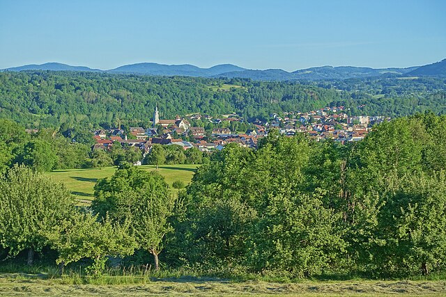
Bernau im Schwarzwald
- municipality in Germany
Hiking in Bernau im Schwarzwald
Bernau im Schwarzwald is a picturesque village in the Black Forest region of Germany, known for its stunning landscapes and rich natural beauty. Hiking in this area offers a variety of trails that cater to different skill levels, making it a great destination for both casual walkers and seasoned hikers....
- Country:
- Postal Code: 79872
- Local Dialing Code: 07675
- Licence Plate Code: WT
- Coordinates: 47° 48' 4" N, 8° 2' 11" E
- GPS tracks (wikiloc): [Link]
- AboveSeaLevel: 932 м m
- Area: 38.04 sq km
- Population: 1925
- Web site: [Link]


Laufenburg (Baden)
- municipality in Germany
Hiking in Laufenburg (Baden)
Laufenburg, located on the banks of the Rhine River, is a charming town straddling the border between Germany and Switzerland. It's well-known for its picturesque old town, historical architecture, and stunning natural scenery. Here are some highlights and tips for hiking in and around Laufenburg:...
- Country:
- Postal Code: 79725
- Local Dialing Code: 07763; 07753
- Licence Plate Code: WT
- Coordinates: 47° 33' 56" N, 8° 3' 53" E
- GPS tracks (wikiloc): [Link]
- AboveSeaLevel: 337 м m
- Area: 23.58 sq km
- Population: 8843
- Web site: [Link]

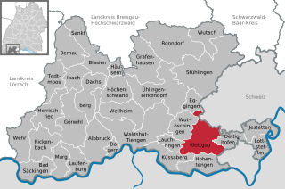
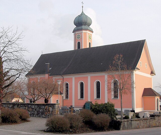
Klettgau
- municipality in Germany
Hiking in Klettgau
Klettgau is an attractive hiking destination located in the southern part of Germany, near the Swiss border, primarily in the Baden-Württemberg region. This area is known for its rolling hills, vineyards, and picturesque landscapes, making it ideal for a variety of hiking experiences. Here are some key points to consider when hiking in Klettgau:...
- Country:
- Postal Code: 79771
- Local Dialing Code: 07742
- Licence Plate Code: WT
- Coordinates: 47° 39' 30" N, 8° 25' 22" E
- GPS tracks (wikiloc): [Link]
- AboveSeaLevel: 409 м m
- Area: 45.87 sq km
- Population: 7478
- Web site: [Link]


Murg
- municipality in Germany
Hiking in Murg
Murg, located in Baden-Württemberg, Germany, is a beautiful area for hiking, offering stunning natural landscapes, diverse trails, and a rich cultural experience. Nestled in the scenic Murg Valley and surrounded by the Black Forest, this region is characterized by lush forests, hills, and rivers, making it an ideal destination for outdoor enthusiasts....
- Country:
- Postal Code: 79730
- Local Dialing Code: 07763
- Licence Plate Code: WT
- Coordinates: 47° 33' 17" N, 8° 1' 27" E
- GPS tracks (wikiloc): [Link]
- AboveSeaLevel: 300 м m
- Area: 20.9 sq km
- Population: 6787
- Web site: [Link]


Rickenbach
- municipality in Germany
Hiking in Rickenbach
Rickenbach is a picturesque village located in the Baden-Württemberg region of Germany, nestled within the beautiful Black Forest. This area offers a myriad of hiking opportunities, characterized by stunning landscapes, diverse flora and fauna, and well-marked trails....
- Country:
- Postal Code: 79736
- Local Dialing Code: 07765
- Licence Plate Code: WT
- Coordinates: 47° 37' 13" N, 7° 58' 42" E
- GPS tracks (wikiloc): [Link]
- AboveSeaLevel: 696 м m
- Area: 34.65 sq km
- Population: 3944
- Web site: [Link]


Küssaberg
- municipality in Germany
Hiking in Küssaberg
Küssaberg, located in the state of Baden-Württemberg, Germany, offers a variety of hiking opportunities that allow you to enjoy the beautiful scenery and unique landscape of the region. Here are some highlights and tips for hiking in and around Küssaberg:...
- Country:
- Postal Code: 79790
- Local Dialing Code: 07741
- Licence Plate Code: WT
- Coordinates: 47° 35' 48" N, 8° 19' 12" E
- GPS tracks (wikiloc): [Link]
- AboveSeaLevel: 330 м m
- Area: 26.16 sq km
- Population: 5326
- Web site: [Link]
Dogern
- municipality in Germany
Hiking in Dogern
Dogern is a small municipality located in the district of Waldshut in Baden-Württemberg, Germany. It's known for its beautiful natural landscapes and proximity to the Rhine River, making it an attractive destination for hiking enthusiasts. Here are some highlights and tips for hiking in Dogern:...
- Country:
- Postal Code: 79804
- Local Dialing Code: 07751
- Licence Plate Code: WT
- Coordinates: 47° 36' 34" N, 8° 10' 2" E
- GPS tracks (wikiloc): [Link]
- AboveSeaLevel: 326 м m
- Area: 7.45 sq km
- Population: 2323
- Web site: [Link]


Herrischried
- municipality in Germany
Hiking in Herrischried
Herrischried is a picturesque village located in the Southern Black Forest region of Germany, known for its beautiful landscapes and outdoor activities, particularly hiking. Here are some key points about hiking in Herrischried:...
- Country:
- Postal Code: 79737
- Local Dialing Code: 07764
- Licence Plate Code: WT
- Coordinates: 47° 40' 0" N, 8° 0' 0" E
- GPS tracks (wikiloc): [Link]
- AboveSeaLevel: 882 м m
- Area: 37.5 sq km
- Population: 2695
- Web site: [Link]
Shares border with regions:

Breisgau-Hochschwarzwald
- district of Baden-Württemberg, Germany
Hiking in Breisgau-Hochschwarzwald
Breisgau-Hochschwarzwald is a spectacular region in southwestern Germany, known for its diverse landscapes, lush forests, and scenic trails. It's located in the state of Baden-Württemberg and offers a myriad of hiking opportunities suitable for all skill levels. Here are some highlights about hiking in the area:...
- Country:
- Capital: Freiburg im Breisgau
- Licence Plate Code: FR
- Coordinates: 47° 57' 0" N, 7° 51' 0" E
- GPS tracks (wikiloc): [Link]
- AboveSeaLevel: 394 м m
- Area: 1378.30 sq km
- Population: 247711
- Web site: [Link]