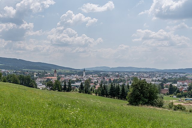
Freistadt District (Bezirk Freistadt)

- district of Austria
 Hiking in Freistadt District
Freistadt District, located in the Upper Austria region of Austria, offers a variety of beautiful landscapes and hiking opportunities for outdoor enthusiasts. Here are some key points to consider when hiking in this area:
Scenic Trails
-
Vast Network of Trails: The Freistadt District has a well-developed network of hiking trails ranging from easy walks to more challenging routes. The scenic paths often lead through lush forests, rolling hills, and meadows.
-
Mühlviertel Region: The district is part of the Mühlviertel, known for its unique landscapes characterized by granite hills and extensive woodlands. Trails vary in difficulty, making it accessible for hikers of all skill levels.
-
Historical Routes: Some trails are steeped in history, offering the chance to explore old trade routes and historical landmarks, including old churches and castles.
Recommended Hikes
- Bergland Tour: This circular route offers stunning views of the surrounding area, with varied terrain that keeps things interesting.
- Pötschenhöhe: A popular peak for a day hike, it rewards climbers with panoramic views.
- Sights near the rivers: Trails along the rivers like the Mühlviertler Bauernwandern route provide serene water views and rich biodiversity.
Nature and Wildlife
- Biodiversity: The region is home to diverse flora and fauna. Keep an eye out for native species along your hike.
- Seasonal Changes: The scenery changes with the seasons, offering vibrant wildflowers in spring, lush greenery in summer, beautiful autumn foliage, and a serene winter landscape.
Practical Tips
- Weather: The weather can change quickly, so always check forecasts before you head out and dress in layers.
- Gear: Good hiking boots and appropriate clothing for the season are essential. A map or a GPS device can be helpful, as signage is not always available on all trails.
- Keep Hydrated: Carry enough water, especially on longer hikes, and bring snacks for energy.
Local Culture
Freistadt District is home to charming villages where you can experience local culture. Consider stopping by for a meal or refreshments at local eateries, and enjoy the regional cuisine.
Safety
- Respect Nature: Stay on marked trails to protect local ecosystems and wildlife.
- Inform Someone: Always let someone know your plans if you're hiking alone or in less populated areas, especially on extended hikes.
With its rich natural beauty and variety of trails, Freistadt District is a fantastic destination for hiking enthusiasts. Enjoy the journey and the breathtaking landscapes!
- Country:

- Capital: Freistadt
- Licence Plate Code: FR
- Coordinates: 48° 26' 38" N, 14° 33' 50" E


- GPS tracks (wikiloc): [Link]
- AboveSeaLevel: 700 м m
- Area: 993.86 sq km
- Web site: http://www.bh-freistadt.gv.at/
- Wikipedia en: wiki(en)
- Wikipedia: wiki(de)
- Wikidata storage: Wikidata: Q257347
- Wikipedia Commons Category: [Link]
- Freebase ID: [/m/0dmcnw]
- GeoNames ID: Alt: [2779274]
- GND ID: Alt: [4018367-1]
- archINFORM location ID: [14669]
Includes regions:
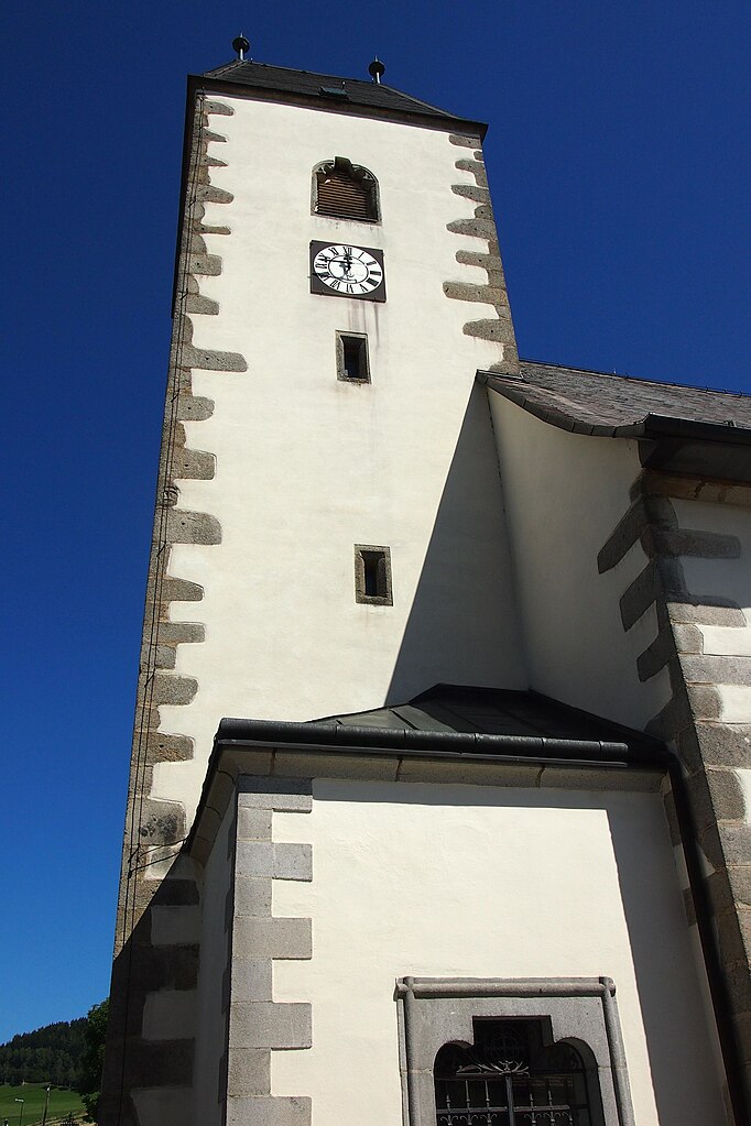
Freistadt
- municipality in Austria
Hiking in Freistadt
Freistadt, located in the Upper Austria region, is surrounded by beautiful landscapes that are ideal for hiking enthusiasts. The area features a variety of trails that cater to different skill levels, from gentle walks suitable for families to more challenging hikes for experienced adventurers....
- Country:
- Postal Code: 4240
- Local Dialing Code: 07942
- Licence Plate Code: FR
- Coordinates: 48° 30' 42" N, 14° 30' 22" E
- GPS tracks (wikiloc): [Link]
- AboveSeaLevel: 560 м m
- Area: 12.88 sq km
- Population: 7909
- Web site: [Link]
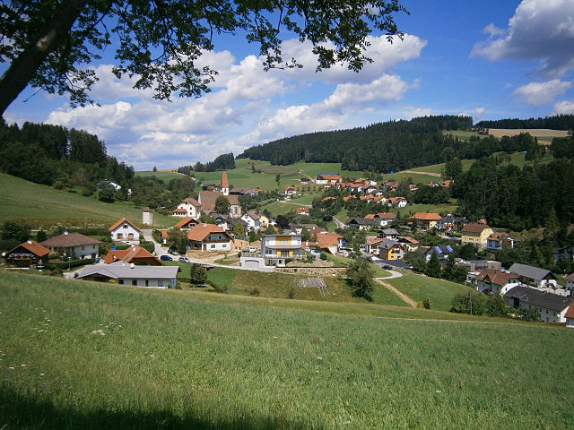
Grünbach, Upper Austria
- municipality in Austria
Hiking in Grünbach, Upper Austria
Grünbach is a charming area located in Upper Austria, known for its beautiful landscapes and hiking opportunities. Here are some key points about hiking in Grünbach:...
- Country:
- Postal Code: 4264
- Local Dialing Code: 07942
- Licence Plate Code: FR
- Coordinates: 48° 32' 20" N, 14° 32' 10" E
- GPS tracks (wikiloc): [Link]
- AboveSeaLevel: 721 м m
- Area: 36.1 sq km
- Population: 1887
- Web site: [Link]

Leopoldschlag
- municipality in Austria
Hiking in Leopoldschlag
Leopoldschlag, located in Austria near the border with the Czech Republic, is a beautiful destination for hiking enthusiasts. Surrounded by the stunning landscapes of the Northern Alps, it offers a variety of trails suitable for different skill levels....
- Country:
- Postal Code: 4262
- Local Dialing Code: 07949
- Licence Plate Code: FR
- Coordinates: 48° 37' 0" N, 14° 30' 0" E
- GPS tracks (wikiloc): [Link]
- AboveSeaLevel: 630 м m
- Area: 25.67 sq km
- Population: 1023
- Web site: [Link]


Hagenberg im Mühlkreis
- municipality in Austria
Hiking in Hagenberg im Mühlkreis
Hagenberg im Mühlkreis is a charming village in Austria, located in the beautiful Mühlviertel region, which is known for its lush green landscapes, rolling hills, and picturesque views. Here’s what you can expect when hiking in this area:...
- Country:
- Postal Code: 4232
- Local Dialing Code: 07236
- Licence Plate Code: FR
- Coordinates: 48° 21' 50" N, 14° 31' 10" E
- GPS tracks (wikiloc): [Link]
- AboveSeaLevel: 444 м m
- Area: 15.1 sq km
- Population: 2737
- Web site: [Link]

Unterweitersdorf
- municipality in Austria
Hiking in Unterweitersdorf
Unterweitersdorf is a picturesque village located in Austria, surrounded by beautiful landscapes that offer a variety of hiking opportunities. When exploring this area, you can find trails that wind through forests, fields, and along rivers, showcasing the stunning natural scenery of the region....
- Country:
- Postal Code: 4210
- Local Dialing Code: 07235
- Licence Plate Code: FR
- Coordinates: 48° 22' 0" N, 14° 28' 0" E
- GPS tracks (wikiloc): [Link]
- AboveSeaLevel: 333 м m
- Area: 11.4 sq km
- Population: 2082
- Web site: [Link]

Windhaag bei Freistadt
- municipality in Austria
Hiking in Windhaag bei Freistadt
Windhaag bei Freistadt is a charming village located in the Mühlviertel region of Austria, surrounded by scenic landscapes perfect for hiking enthusiasts. The area is known for its rolling hills, lush forests, and beautiful meadows, making it a great spot for outdoor activities....
- Country:
- Postal Code: 4263
- Local Dialing Code: 07943
- Licence Plate Code: FR
- Coordinates: 48° 35' 10" N, 14° 33' 50" E
- GPS tracks (wikiloc): [Link]
- AboveSeaLevel: 723 м m
- Area: 42.9 sq km
- Population: 1579
- Web site: [Link]

Pierbach
- municipality in Austria
Hiking in Pierbach
Pierbach is a charming village located in Austria, surrounded by beautiful natural landscapes, making it an excellent destination for hiking enthusiasts. Here are some highlights about hiking in the region:...
- Country:
- Postal Code: 4282
- Local Dialing Code: 07267
- Licence Plate Code: FR
- Coordinates: 48° 20' 50" N, 14° 45' 20" E
- GPS tracks (wikiloc): [Link]
- AboveSeaLevel: 494 м m
- Area: 22.7 sq km
- Population: 1011
- Web site: [Link]

Pregarten
- municipality in Austria
Hiking in Pregarten
Pregarten, located in Upper Austria, is a charming town that serves as a gateway for various outdoor activities, including hiking. The surrounding landscape is characterized by gently rolling hills, lush forests, and picturesque natural scenery, making it an excellent destination for both beginner and experienced hikers....
- Country:
- Postal Code: 4230
- Local Dialing Code: 07236
- Licence Plate Code: FR
- Coordinates: 48° 21' 20" N, 14° 31' 50" E
- GPS tracks (wikiloc): [Link]
- AboveSeaLevel: 425 м m
- Area: 27.8 sq km
- Population: 5293
- Web site: [Link]

Sandl
- municipality in the district of Freistadt in Upper Austria, Austria
Hiking in Sandl
Sandl is a beautiful area in Austria, known for its scenic landscapes and tranquil surroundings, making it a great destination for hikers of all skill levels. Nestled in the Mühlviertel region of Upper Austria, Sandl offers a variety of hiking trails that showcase the natural beauty of the region, including rolling hills, lush forests, and panoramic views....
- Country:
- Postal Code: 4251
- Local Dialing Code: 07944
- Licence Plate Code: FR
- Coordinates: 48° 33' 40" N, 14° 38' 40" E
- GPS tracks (wikiloc): [Link]
- AboveSeaLevel: 927 м m
- Area: 58.4 sq km
- Population: 1384
- Web site: [Link]
Hirschbach im Mühlkreis
- municipality in Austria
Hiking in Hirschbach im Mühlkreis
Hirschbach im Mühlkreis is a charming village located in the Mühlviertel region of Upper Austria, surrounded by lush landscapes and rolling hills, making it an excellent destination for hiking enthusiasts....
- Country:
- Postal Code: 4242
- Local Dialing Code: 07948
- Licence Plate Code: FR
- Coordinates: 48° 29' 19" N, 14° 24' 44" E
- GPS tracks (wikiloc): [Link]
- AboveSeaLevel: 640 м m
- Area: 23.6 sq km
- Population: 1194
- Web site: [Link]
Kaltenberg
- municipality in Austria
Hiking in Kaltenberg
Kaltenberg, located in Bavaria, Germany, is known for its picturesque landscapes and rich natural beauty, making it a great destination for hiking enthusiasts. Here's an overview of what you can expect when hiking in and around Kaltenberg:...
- Country:
- Postal Code: 4273
- Local Dialing Code: 07956
- Licence Plate Code: FR
- Coordinates: 48° 27' 0" N, 14° 46' 0" E
- GPS tracks (wikiloc): [Link]
- AboveSeaLevel: 842 м m
- Area: 17.1 sq km
- Population: 625
- Web site: [Link]

Kefermarkt
- municipality in Austria
Hiking in Kefermarkt
Kefermarkt, located in the Mühlviertel region of Austria, offers a scenic and tranquil environment for hiking enthusiasts. The area is characterized by beautiful landscapes, rolling hills, forests, and meadows, providing a perfect backdrop for outdoor activities....
- Country:
- Postal Code: 4292
- Local Dialing Code: 07947
- Licence Plate Code: FR
- Coordinates: 48° 26' 37" N, 14° 31' 2" E
- GPS tracks (wikiloc): [Link]
- AboveSeaLevel: 516 м m
- Area: 27.8 sq km
- Population: 2083
- Web site: [Link]

Königswiesen
- municipality in Austria
Hiking in Königswiesen
Königswiesen, located in the beautiful region of Bavaria in Germany, offers a variety of hiking experiences that cater to different skill levels. The area is known for its stunning landscapes, lush forests, and picturesque trails. Here’s what you should know about hiking in Königswiesen:...
- Country:
- Postal Code: 4280
- Local Dialing Code: 07955
- Licence Plate Code: FR
- Coordinates: 48° 24' 28" N, 14° 50' 29" E
- GPS tracks (wikiloc): [Link]
- AboveSeaLevel: 614 м m
- Area: 73.39 sq km
- Population: 3113
- Web site: [Link]

Rainbach im Mühlkreis
- municipality in Austria
Hiking in Rainbach im Mühlkreis
Rainbach im Mühlkreis, located in the scenic region of Upper Austria, offers a lovely hiking experience for outdoor enthusiasts. The area is characterized by its lush forests, rolling hills, and picturesque views of the surrounding countryside, making it an ideal destination for hikers of all levels....
- Country:
- Postal Code: 4261
- Local Dialing Code: 07949
- Licence Plate Code: FR
- Coordinates: 48° 33' 40" N, 14° 28' 40" E
- GPS tracks (wikiloc): [Link]
- AboveSeaLevel: 719 м m
- Area: 49.1 sq km
- Population: 2959
- Web site: [Link]

Bad Zell
- municipality in Austria
Hiking in Bad Zell
Bad Zell, located in the beautiful region of Upper Austria, offers a range of hiking opportunities for nature enthusiasts and adventure seekers. The area is characterized by its picturesque landscapes, lush forests, and rolling hills, making it a great destination for hikers of all skill levels....
- Country:
- Postal Code: 4283
- Local Dialing Code: 07263
- Licence Plate Code: FR
- Coordinates: 48° 21' 0" N, 14° 40' 0" E
- GPS tracks (wikiloc): [Link]
- AboveSeaLevel: 515 м m
- Area: 45.5 sq km
- Population: 2868
- Web site: [Link]

Liebenau
- municipality in Austria
Hiking in Liebenau
Liebenau, a charming village in Upper Austria, is surrounded by beautiful natural landscapes that are perfect for hiking enthusiasts. The area is characterized by rolling hills, lush forests, and serene valleys, offering a variety of trails suitable for all levels of hikers....
- Country:
- Postal Code: 4252
- Local Dialing Code: 07953
- Licence Plate Code: FR
- Coordinates: 48° 31' 50" N, 14° 48' 20" E
- GPS tracks (wikiloc): [Link]
- AboveSeaLevel: 970 м m
- Area: 76.3 sq km
- Population: 1597
- Web site: [Link]
Tragwein
- municipality in Austria
Hiking in Tragwein
Tragwein, located in the Upper Austria region, offers some serene hiking opportunities amidst beautiful natural landscapes. The area is characterized by rolling hills, lush forests, and picturesque views of the surrounding countryside, making it an excellent choice for hikers of all levels....
- Country:
- Postal Code: 4284
- Local Dialing Code: 07263
- Licence Plate Code: FR
- Coordinates: 48° 19' 50" N, 14° 37' 20" E
- GPS tracks (wikiloc): [Link]
- AboveSeaLevel: 491 м m
- Area: 39.5 sq km
- Population: 3082
- Web site: [Link]


Gutau
- municipality in Austria
Hiking in Gutau
Gutau, located in the Mühlviertel region of Austria, is a lovely destination for hiking enthusiasts. The area is characterized by its beautiful landscapes, dense forests, rolling hills, and picturesque meadows, offering various trails suited for different skill levels....
- Country:
- Postal Code: 4293
- Local Dialing Code: 07946
- Coordinates: 48° 25' 0" N, 14° 36' 0" E
- GPS tracks (wikiloc): [Link]
- AboveSeaLevel: 589 м m
- Area: 45.44 sq km
- Population: 2724
- Web site: [Link]

Waldburg
- municipality in the district of Freistadt in Upper Austria
Hiking in Waldburg
Waldburg, located in the picturesque region of Austria, is not only a charming village but also offers various opportunities for hiking enthusiasts. Nestled in the Austrian countryside, it provides access to stunning landscapes, rich flora, and opportunities to explore the unique alpine environment. Here are some aspects to consider when hiking in and around Waldburg:...
- Country:
- Postal Code: 4240
- Local Dialing Code: 07942
- Licence Plate Code: FR
- Coordinates: 48° 30' 30" N, 14° 26' 20" E
- GPS tracks (wikiloc): [Link]
- AboveSeaLevel: 685 м m
- Area: 26.58 sq km
- Population: 1375
- Web site: [Link]

Neumarkt im Mühlkreis
- municipality in Austria
Hiking in Neumarkt im Mühlkreis
Neumarkt im Mühlkreis, located in the Upper Austria region, is a beautiful destination for hiking enthusiasts. The area is known for its stunning landscapes, featuring rolling hills, lush forests, and picturesque views of the Mühlviertel region. Here are some key highlights of hiking in and around Neumarkt im Mühlkreis:...
- Country:
- Postal Code: 4212
- Local Dialing Code: 07941
- Licence Plate Code: FR
- Coordinates: 48° 25' 40" N, 14° 29' 0" E
- GPS tracks (wikiloc): [Link]
- AboveSeaLevel: 632 м m
- Area: 46.7 sq km
- Population: 3163
- Web site: [Link]

Wartberg ob der Aist
- municipality in Austria
Hiking in Wartberg ob der Aist
Wartberg ob der Aist is a charming municipality located in the northern region of Upper Austria, surrounded by beautiful landscapes that make it an excellent destination for hiking enthusiasts. The area is characterized by scenic hills, lush forests, and tranquil rivers, providing a variety of hiking trails suitable for different skill levels....
- Country:
- Postal Code: 4224
- Local Dialing Code: 07236
- Licence Plate Code: FR
- Coordinates: 48° 20' 50" N, 14° 30' 30" E
- GPS tracks (wikiloc): [Link]
- AboveSeaLevel: 477 м m
- Area: 19.4 sq km
- Population: 4222
- Web site: [Link]

Unterweißenbach
- municipality in Austria
Hiking in Unterweißenbach
Unterweißenbach, located in Austria, is a fantastic destination for hiking enthusiasts. Nestled in the picturesque landscape of the Mühlviertel region in Upper Austria, it offers diverse trails that cater to different skill levels, from easy walks suitable for families to more challenging hikes for experienced trekkers....
- Country:
- Postal Code: 4273
- Local Dialing Code: 07956
- Licence Plate Code: FR
- Coordinates: 48° 26' 10" N, 14° 46' 55" E
- GPS tracks (wikiloc): [Link]
- AboveSeaLevel: 640 м m
- Area: 48.7 sq km
- Population: 2192
- Web site: [Link]

Lasberg
- municipality in Austria
Hiking in Lasberg
Lasberg, a scenic village in Austria, offers some beautiful hiking opportunities that cater to various skill levels. Situated in the Mühlviertel region of Upper Austria, it features rolling hills, lush forests, and serene landscapes. Here are some highlights and tips for hiking in Lasberg:...
- Country:
- Postal Code: 4291
- Local Dialing Code: 07947
- Licence Plate Code: FR
- Coordinates: 48° 28' 20" N, 14° 32' 30" E
- GPS tracks (wikiloc): [Link]
- AboveSeaLevel: 574 м m
- Area: 43.8 sq km
- Population: 2748
- Web site: [Link]

Sankt Oswald bei Freistadt
- municipality in Austria
Hiking in Sankt Oswald bei Freistadt
Sankt Oswald bei Freistadt is a charming municipality in Austria, known for its stunning natural landscapes and diverse hiking opportunities. Nestled in the Mühlviertel region of Upper Austria, it offers a mix of forested trails, rolling hills, and picturesque views....
- Country:
- Postal Code: 4271
- Local Dialing Code: 07945
- Licence Plate Code: FR
- Coordinates: 48° 30' 0" N, 14° 35' 0" E
- GPS tracks (wikiloc): [Link]
- AboveSeaLevel: 608 м m
- Area: 40.9 sq km
- Population: 2901
- Web site: [Link]


Sankt Leonhard bei Freistadt
- municipality in Austria
Hiking in Sankt Leonhard bei Freistadt
Sankt Leonhard bei Freistadt is located in the scenic region of Upper Austria, which offers a variety of hiking opportunities. This charming area is characterized by its lush landscapes, rolling hills, and rich cultural heritage, making it a great destination for outdoor enthusiasts....
- Country:
- Postal Code: 4294
- Local Dialing Code: 07952
- Licence Plate Code: FR
- Coordinates: 48° 26' 40" N, 14° 40' 40" E
- GPS tracks (wikiloc): [Link]
- AboveSeaLevel: 810 м m
- Area: 35 sq km
- Population: 1394
- Web site: [Link]

Weitersfelden
- municipality in Austria
Hiking in Weitersfelden
Weitersfelden is a picturesque village located in the picturesque Mühlviertel region of Austria, known for its stunning landscapes, rolling hills, and dense forests. Hiking in and around Weitersfelden offers a range of trails suitable for various skill levels, making it a great destination for outdoor enthusiasts....
- Country:
- Postal Code: 4272
- Local Dialing Code: 07952
- Licence Plate Code: FR
- Coordinates: 48° 28' 40" N, 14° 43' 40" E
- GPS tracks (wikiloc): [Link]
- AboveSeaLevel: 733 м m
- Area: 43.7 sq km
- Population: 1042
- Web site: [Link]
Schönau im Mühlkreis
- municipality in Austria
Hiking in Schönau im Mühlkreis
Schönau im Mühlkreis is a picturesque area in Upper Austria, known for its stunning landscapes and natural beauty, making it an excellent destination for hiking enthusiasts. Nestled in the foothills of the Mühlviertel region, this area offers a variety of hiking trails catering to different skill levels, from leisurely walks to more challenging routes....
- Country:
- Postal Code: 4274
- Local Dialing Code: 07261
- Licence Plate Code: FR
- Coordinates: 48° 23' 40" N, 14° 43' 48" E
- GPS tracks (wikiloc): [Link]
- AboveSeaLevel: 635 м m
- Area: 38.5 sq km
- Population: 1941
- Web site: [Link]