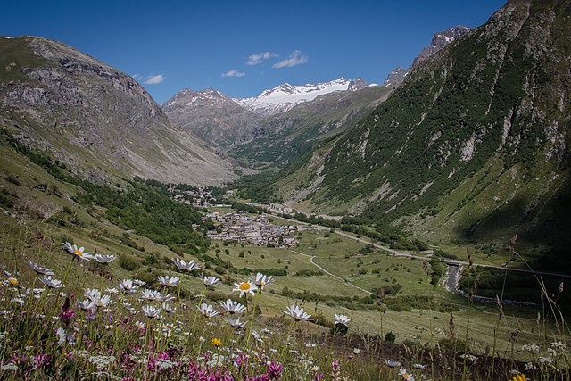
Bessans (Bessans)

- коммуна во Франции
 Hiking in Bessans
Bessans is a picturesque village located in the Savoie region of the French Alps, known for its stunning landscapes and outdoor activities, including hiking. Nestled at an altitude of about 1,740 meters, it offers a range of trails suitable for various skill levels, making it a great destination for both experienced hikers and families.
Hiking Trails
-
Les Lacs de la Partie: This moderate trail takes you to beautiful alpine lakes, offering stunning views of the surrounding peaks. It's about 6 km round trip, with a gentle ascent.
-
Col des buses: For more experienced hikers, this trail leads to the Col des Buses, providing breathtaking panoramas of the Vanoise National Park. Expect some rocky paths and steeper sections.
-
Sentier des Cimes: This is a family-friendly loop trail that allows you to explore the flora and fauna of the region while enjoying easier terrain. It's approximately 5 km and is perfect for a leisurely hike.
-
Belvédère du Grand Bec: A more challenging hike that rewards you with breathtaking views of the Grand Bec and other surrounding peaks. This path requires good physical condition and some hiking experience.
Flora and Fauna
While hiking in Bessans, you'll have the opportunity to see diverse alpine flora and fauna. Keep an eye out for ibex, chamois, and a variety of bird species, as well as many unique mountain plants and wildflowers.
Best Time to Hike
The hiking season typically runs from late spring to early fall (May to October). During summer months, the trails are generally clear of snow, making it an ideal time to explore. Be mindful of weather conditions and always check forecasts before heading out.
Preparation Tips
- Gear: Wear appropriate hiking boots, bring layers for variable weather, and don't forget sun protection and a good backpack.
- Safety: Always carry a map or GPS device and inform someone of your hiking plans. Consider hiking with a buddy, especially on more remote trails.
- Hydration & Snacks: Always bring plenty of water and snacks, as many trails do not have water sources available.
Local Amenities
Bessans has several facilities for hikers, including tourist information centers, shops, and restaurants. Local guides are often available for those who prefer a guided experience or want to learn more about the area’s natural history.
Whether you're looking for a casual walk or a rigorous trek, Bessans has something to offer for every hiking enthusiast. Enjoy the stunning alpine scenery and the tranquility of the mountains!
- Страна:

- Почтовый код: 73480
- Координаты: 45° 19' 12" N, 6° 59' 37" E


- GPS треки (wikiloc): [Ссылка]
- Высота над уровнем моря: 1750 м m
- Площадь: 128.08 кв.км
- Население: 338
- Веб сайт: http://www.bessans.com
- Википедия английская: wiki(en)
- Википедия национальная: wiki(fr)
- Хранилище Wikidata: Wikidata: Q735306
- Катеория в википедии: [Ссылка]
- код Freebase: [/m/03mb4dd]
- код GeoNames: Альт: [3033097]
- номер SIREN: [217300409]
- код BNF: [152739763]
- код VIAF: Альт: [168615046]
- код LCNAF: Альт: [n83216720]
- код тезауруса PACTOLS: [pcrtwTWg9agXvG]
- код муниципалитета INSEE: 73040
Граничит с регионами:


Уссельо
- коммуна в Италии
Hiking in Уссельо
Usseglio, located in the Susa Valley in the Piedmont region of Italy, is a beautiful destination for hikers and outdoor enthusiasts. Known for its stunning alpine scenery, Usseglio offers a variety of trails that cater to different skill levels, making it an ideal spot for both beginners and experienced hikers....
- Страна:

- Почтовый код: 10070
- Телефонный код: 0123
- Код автомобильного номера: TO
- Координаты: 45° 14' 0" N, 7° 13' 0" E
- GPS треки (wikiloc): [Ссылка]
- Высота над уровнем моря: 1260 м m
- Площадь: 98.54 кв.км
- Население: 200
- Веб сайт: [Ссылка]


Lanslevillard
- коммуна во Франции
Hiking in Lanslevillard
Lanslevillard, located in the Savoie region of France, is a beautiful destination for hiking enthusiasts. Nestled in the heart of the French Alps, this charming alpine village offers a range of hiking trails that cater to all experience levels, from beginners to seasoned hikers. Here are some key highlights about hiking in Lanslevillard:...
- Страна:
- Почтовый код: 73480
- Координаты: 45° 17' 22" N, 6° 54' 42" E
- GPS треки (wikiloc): [Ссылка]
- Площадь: 39.84 кв.км
- Население: 468
- Веб сайт: [Ссылка]


Валь-д'Изер
- коммуна во Франции
Hiking in Валь-д'Изер
Val-d'Isère, located in the French Alps, is a renowned ski resort that also offers spectacular hiking opportunities during the summer months. The area is known for its breathtaking mountain scenery, alpine meadows, and a variety of hiking trails suitable for different skill levels. Here are some highlights to consider if you plan to hike in Val-d'Isère:...
- Страна:
- Почтовый код: 73150
- Координаты: 45° 26' 59" N, 6° 58' 38" E
- GPS треки (wikiloc): [Ссылка]
- Высота над уровнем моря: 1850 м m
- Площадь: 94.39 кв.км
- Население: 1583
- Веб сайт: [Ссылка]


Termignon
- коммуна во Франции
Hiking in Termignon
Termignon is a charming village located in the Maurienne Valley in the French Alps, part of the Savoie region. It offers a variety of hiking opportunities for outdoor enthusiasts, ranging from leisurely walks to challenging treks with stunning views of the surrounding mountains and valleys. Here are some highlights of hiking in and around Termignon:...
- Страна:
- Почтовый код: 73500
- Координаты: 45° 16' 39" N, 6° 49' 1" E
- GPS треки (wikiloc): [Ссылка]
- Площадь: 149.03 кв.км
- Население: 400
- Веб сайт: [Ссылка]
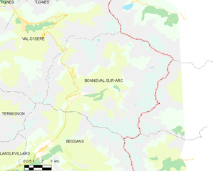
Bonneval-sur-Arc
- коммуна во Франции
Hiking in Bonneval-sur-Arc
Bonneval-sur-Arc is a stunning location for hiking, situated in the French Alps within the Vanoise National Park. Known for its picturesque landscapes, high peaks, and well-preserved alpine environment, it offers a range of trails suitable for different levels of hikers....
- Страна:
- Почтовый код: 73480
- Координаты: 45° 22' 16" N, 7° 2' 47" E
- GPS треки (wikiloc): [Ссылка]
- Площадь: 82.72 кв.км
- Население: 255
- Веб сайт: [Ссылка]
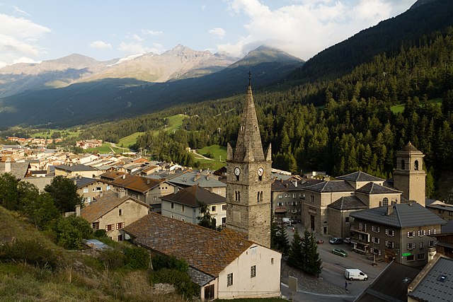

Ланлебур-Мон-Сени
- коммуна во Франции
Hiking in Ланлебур-Мон-Сени
Lanslebourg-Mont-Cenis, located in the Savoie region of France, is a stunning destination for hiking enthusiasts. Nestled in the French Alps, this area offers a variety of trails that cater to different levels of hiking experience, from gentle walks to more challenging climbs....
- Страна:
- Почтовый код: 73480
- Координаты: 45° 17' 9" N, 6° 52' 45" E
- GPS треки (wikiloc): [Ссылка]
- Площадь: 93.61 кв.км
- Население: 649
- Веб сайт: [Ссылка]

Бальме
- коммуна Италии
Hiking in Бальме
Balme is a charming village located in the Susa Valley of the Piedmont region in Italy. It's known for its breathtaking natural scenery, rugged terrain, and as a gateway to various hiking opportunities. Here are some key points about hiking in Balme:...
- Страна:
- Почтовый код: 10070
- Телефонный код: 0123
- Код автомобильного номера: TO
- Координаты: 45° 18' 0" N, 7° 13' 0" E
- GPS треки (wikiloc): [Ссылка]
- Высота над уровнем моря: 1432 м m
- Площадь: 62.71 кв.км
- Население: 111
- Веб сайт: [Ссылка]


Новалеза
- коммуна Италии
Hiking in Новалеза
Novalesa is a picturesque village located in the Susa Valley of the Piedmont region in northern Italy. It is surrounded by the stunning natural beauty of the Alps, making it an excellent spot for hiking enthusiasts. Here’s what you can expect when hiking in and around Novalesa:...
- Страна:
- Почтовый код: 10050
- Телефонный код: 0122
- Код автомобильного номера: TO
- Координаты: 45° 11' 0" N, 7° 1' 0" E
- GPS треки (wikiloc): [Ссылка]
- Высота над уровнем моря: 828 м m
- Площадь: 28.55 кв.км
- Население: 542
- Веб сайт: [Ссылка]