canton of Lanslebourg-Mont-Cenis (canton de Lanslebourg-Mont-Cenis)
 Hiking in canton of Lanslebourg-Mont-Cenis
Canton de Lanslebourg-Mont-Cenis, located in the Savoie region of the French Alps, offers stunning landscapes and a variety of hiking opportunities. The area is renowned for its picturesque mountain scenery, charming alpine villages, and diverse flora and fauna.
Key Highlights for Hiking in Canton de Lanslebourg-Mont-Cenis:
1.
- Lanslebourg to Mont Cenis Lake: This trail offers breathtaking views of the lake and the surrounding peaks. It’s a moderate hike suitable for families and novice hikers.
- Col du Mont-Cenis: A higher-altitude trail that leads you to the French-Italian border, offering stunning panoramic views. This may be more suited for experienced hikers due to its altitude and terrain.
2.
- The area is rich in biodiversity, and hikers may encounter various alpine plants and wildlife, such as ibex and chamois. The peace and tranquility of the mountains make it a favored spot for nature lovers.
3.
- The trails often pass through quaint villages, allowing hikers to experience local culture, architecture, and cuisine. Stop by local shops or cafés to taste Savoyard specialties.
4.
- Summer Hiking (June to September): The best time for hiking, with most trails accessible and wildflowers in bloom.
- Winter Hiking/Snowshoeing (December to March): Many trails become great for snowshoeing, and some areas are suitable for winter hiking.
5.
- Maps and Guides: Always carry a detailed map or GPS device, as some trails can be less marked.
- Gear: Dress in layers, wear sturdy hiking boots, and bring essentials like water, snacks, and a first-aid kit.
6.
- If you prefer structured tours, consider joining a local hiking group or hiring a guide who can provide insights about the area’s history and ecology.
Conclusion:
Hiking in Canton de Lanslebourg-Mont-Cenis offers something for everyone—from leisurely strolls by the lake to challenging mountain ascents. Make sure to check current trail conditions and local advisories before you go, and enjoy your time exploring this beautiful alpine region!
- Страна:

- Столица: Ланлебур-Мон-Сени
- Координаты: 45° 14' 38" N, 6° 55' 35" E


- GPS треки (wikiloc): [Ссылка]
- Хранилище Wikidata: Wikidata: Q1122399
- код кантона INSEE: [7316]
Включает регионы:


Lanslevillard
- коммуна во Франции
Hiking in Lanslevillard
Lanslevillard, located in the Savoie region of France, is a beautiful destination for hiking enthusiasts. Nestled in the heart of the French Alps, this charming alpine village offers a range of hiking trails that cater to all experience levels, from beginners to seasoned hikers. Here are some key highlights about hiking in Lanslevillard:...
- Страна:
- Почтовый код: 73480
- Координаты: 45° 17' 22" N, 6° 54' 42" E
- GPS треки (wikiloc): [Ссылка]
- Площадь: 39.84 кв.км
- Население: 468
- Веб сайт: [Ссылка]


Bramans
- коммуна во Франции
Hiking in Bramans
Bramans is a charming village located in the Savoie region of the French Alps, known for its stunning natural landscapes and outdoor activities, including hiking. The area offers a variety of hiking trails that cater to different skill levels, making it a great destination for both beginner and experienced hikers....
- Страна:
- Почтовый код: 73500
- Координаты: 45° 13' 25" N, 6° 46' 34" E
- GPS треки (wikiloc): [Ссылка]
- Площадь: 92.26 кв.км
- Население: 435
- Веб сайт: [Ссылка]


Termignon
- коммуна во Франции
Hiking in Termignon
Termignon is a charming village located in the Maurienne Valley in the French Alps, part of the Savoie region. It offers a variety of hiking opportunities for outdoor enthusiasts, ranging from leisurely walks to challenging treks with stunning views of the surrounding mountains and valleys. Here are some highlights of hiking in and around Termignon:...
- Страна:
- Почтовый код: 73500
- Координаты: 45° 16' 39" N, 6° 49' 1" E
- GPS треки (wikiloc): [Ссылка]
- Площадь: 149.03 кв.км
- Население: 400
- Веб сайт: [Ссылка]


Sollières-Sardières
- коммуна во Франции
Hiking in Sollières-Sardières
Sollières-Sardières is a charming village located in the French Alps, nestled between the Vanoise National Park and the Italian border. This region is known for its stunning mountain landscapes, rich biodiversity, and extensive hiking trails, making it an excellent destination for hikers of all levels....
- Страна:
- Почтовый код: 73500
- Координаты: 45° 15' 51" N, 6° 48' 30" E
- GPS треки (wikiloc): [Ссылка]
- Площадь: 33.31 кв.км
- Население: 189
- Веб сайт: [Ссылка]

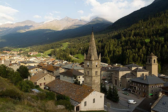
Bessans
- коммуна во Франции
Hiking in Bessans
Bessans is a picturesque village located in the Savoie region of the French Alps, known for its stunning landscapes and outdoor activities, including hiking. Nestled at an altitude of about 1,740 meters, it offers a range of trails suitable for various skill levels, making it a great destination for both experienced hikers and families....
- Страна:
- Почтовый код: 73480
- Координаты: 45° 19' 12" N, 6° 59' 37" E
- GPS треки (wikiloc): [Ссылка]
- Высота над уровнем моря: 1750 м m
- Площадь: 128.08 кв.км
- Население: 338
- Веб сайт: [Ссылка]
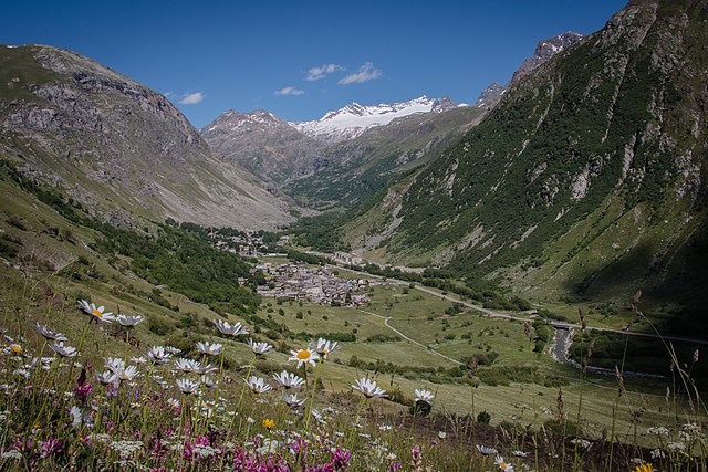
Bonneval-sur-Arc
- коммуна во Франции
Hiking in Bonneval-sur-Arc
Bonneval-sur-Arc is a stunning location for hiking, situated in the French Alps within the Vanoise National Park. Known for its picturesque landscapes, high peaks, and well-preserved alpine environment, it offers a range of trails suitable for different levels of hikers....
- Страна:
- Почтовый код: 73480
- Координаты: 45° 22' 16" N, 7° 2' 47" E
- GPS треки (wikiloc): [Ссылка]
- Площадь: 82.72 кв.км
- Население: 255
- Веб сайт: [Ссылка]

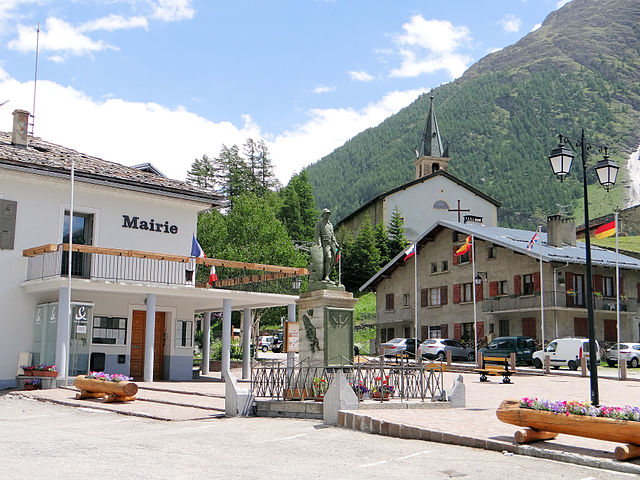
Ланлебур-Мон-Сени
- коммуна во Франции
Hiking in Ланлебур-Мон-Сени
Lanslebourg-Mont-Cenis, located in the Savoie region of France, is a stunning destination for hiking enthusiasts. Nestled in the French Alps, this area offers a variety of trails that cater to different levels of hiking experience, from gentle walks to more challenging climbs....
- Страна:
- Почтовый код: 73480
- Координаты: 45° 17' 9" N, 6° 52' 45" E
- GPS треки (wikiloc): [Ссылка]
- Площадь: 93.61 кв.км
- Население: 649
- Веб сайт: [Ссылка]