
Шамони-Мон-Блан (Chamonix-Mont-Blanc, Chamonix-Mont-Blanc)

- коммуна во Франции
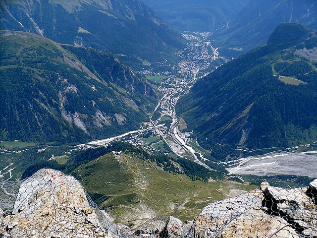
 Hiking in Шамони-Мон-Блан
Chamonix, located in the French Alps, is a renowned destination for hiking enthusiasts of all levels. Nestled at the foot of Mont Blanc, the highest mountain in Western Europe, Chamonix offers stunning landscapes, diverse terrain, and a variety of trails to explore. Here are some key points to consider when hiking in Chamonix:
Trails and Routes
-
Beginner Trails:
- Parc de Merlet: A family-friendly hike with beautiful views of Mont Blanc and opportunities to see wildlife.
- Lac des Gaillands: An easy hike that leads to a picturesque lake, perfect for a picnic.
-
Intermediate Trails:
- Lake Blanc: A scenic hike offering incredible views of Mont Blanc and surrounding peaks. The trail begins at the Granges de Servoz and can be reached via the Brevent gondola.
- Le Tour: This route offers a well-marked path with stunning views and varying elevation, suitable for those with moderate hiking experience.
-
Advanced Trails:
- Tour du Mont Blanc: A multi-day trek around Mont Blanc that covers 170 km (about 106 miles), providing spectacular views and cultural experiences as it passes through France, Italy, and Switzerland.
- Aiguille du Midi: While not a traditional hike, the cable car ride takes you to the summit at 3,842 meters. From there, you can access various high-altitude trails and breathtaking views.
Best Time to Hike
- Summer (June to September): The most popular time for hiking, with all trails open and accessible. The weather is generally mild, but be prepared for occasional rain.
- Autumn (late September to October): Beautiful foliage and fewer crowds, although some trails may begin to close.
- Winter (November to April): While hiking trails can be covered in snow, there are opportunities for snowshoeing and winter hiking.
Safety and Preparation
- Gear: Sturdy hiking boots, weather-appropriate clothing, a hat, sunscreen, and plenty of water are essential. Trekking poles can also be beneficial for stability, especially in hilly or uneven terrain.
- Navigation: Although trails are well-marked, having a map or a navigation app is advisable. Consider downloading offline maps for areas with limited cell reception.
- Weather: Always check the weather forecast before heading out, as conditions can change rapidly in the mountains.
Local Tips
- Visitor Center: Stop by the Chamonix Tourist Office for maps, trail recommendations, and any advice on current conditions.
- Guided Tours: If you’re unfamiliar with the area or prefer to hike with someone knowledgeable, consider joining a guided hike.
Conclusion
Chamonix offers a remarkable experience for hikers, with trails that showcase the breathtaking beauty of the Alps. Whether you're looking for a leisurely walk or a challenging trek, Chamonix has something for everyone. Always prioritize safety, respect nature, and enjoy the adventure!
- Страна:

- Почтовый код: 74400
- Координаты: 45° 55' 20" N, 6° 52' 8" E


- GPS треки (wikiloc): [Ссылка]
- Высота над уровнем моря: 1030 м m
- Площадь: 116.53 кв.км
- Население: 8906
- Веб сайт: http://www.chamonix.fr
- Википедия русская: wiki(ru)
- Википедия английская: wiki(en)
- Википедия национальная: wiki(fr)
- Хранилище Wikidata: Wikidata: Q83236
- Галерея изображений в википедии: [Ссылка]
- Катеория в википедии: [Ссылка]
- код Freebase: [/m/0ps3g]
- код GeoNames: Альт: [3027301]
- номер SIREN: [217400563]
- код BNF: [15274315g]
- код VIAF: Альт: [315153102]
- ID отношения в OpenStreetMap: [104836]
- код GND: Альт: [4085208-8]
- код LCNAF: Альт: [n81018276]
- место в MusicBrainz: [2a3dbf93-5d34-4b36-bbe0-9e3ff7883803]
- код темы Quora: [Chamonix-Mont-Blanc]
- код в энциклопедии «Британника онлайн»: [place/Chamonix-Mont-Blanc]
- код в Большой каталанской энциклопедии: [0017319]
- код в Большой российской энциклопедии онлайн: [4690075]
- dmoz: Альт: [Regional/Europe/France/Regions/Rhone-Alpes/Haute-Savoie/Localities/Chamonix/]
- код YSO: [170638]
- код муниципалитета INSEE: 74056
- код US National Archives: 10038034
Граничит с регионами:

Курмайёр
- коммуна Италии
Hiking in Курмайёр
Courmayeur, located in the Aosta Valley of Italy, is a fantastic destination for hikers. Nestled at the foot of Mont Blanc, the area offers a variety of trails that cater to all skill levels, from leisurely walks to challenging alpine hikes. Here are some highlights for hiking in Courmayeur:...
- Страна:

- Почтовый код: 11013
- Телефонный код: 0165
- Код автомобильного номера: AO
- Координаты: 45° 47' 0" N, 6° 58' 0" E
- GPS треки (wikiloc): [Ссылка]
- Высота над уровнем моря: 1224 м m
- Площадь: 210 кв.км
- Население: 2798
- Веб сайт: [Ссылка]


Passy
Hiking in Passy
Passy, located in the Haute-Savoie region of France, is a beautiful destination for hiking enthusiasts with its stunning alpine scenery and diverse trails. Here are some highlights and tips for hiking in and around Passy:...
- Страна:
- Почтовый код: 74480
- Координаты: 45° 55' 25" N, 6° 41' 11" E
- GPS треки (wikiloc): [Ссылка]
- Площадь: 80.03 кв.км
- Население: 11011
- Веб сайт: [Ссылка]


Лез-Уш
- коммуна во Франции, горнолыжный альпийский курорт
Hiking in Лез-Уш
Les Houches is a beautiful village located in the Chamonix Valley of the French Alps, and it offers a wide variety of hiking opportunities suitable for all skill levels. Here are some highlights and information regarding hiking in Les Houches:...
- Страна:
- Почтовый код: 74310
- Координаты: 45° 53' 24" N, 6° 47' 55" E
- GPS треки (wikiloc): [Ссылка]
- Высота над уровнем моря: 1001 м m
- Площадь: 43.07 кв.км
- Население: 2934
- Веб сайт: [Ссылка]


Сервоз
- коммуна во Франции
Hiking in Сервоз
Servoz, a charming village in the Haute-Savoie region of the French Alps, offers a variety of hiking opportunities for outdoor enthusiasts of all levels. Nestled at the foot of the Mont Blanc massif, it provides stunning views and access to scenic trails amidst beautiful alpine landscapes. Here are some highlights of hiking in Servoz:...
- Страна:
- Почтовый код: 74310
- Координаты: 45° 55' 50" N, 6° 46' 2" E
- GPS треки (wikiloc): [Ссылка]
- Площадь: 13.47 кв.км
- Население: 916


Валорсин
- коммуна во Франции
Hiking in Валорсин
Vallorcine is a beautiful village located in the Chamonix Mont-Blanc region of the French Alps, and it's a fantastic destination for hiking enthusiasts. Nestled in a picturesque valley, Vallorcine offers a variety of trails suitable for different skill levels, ranging from gentle walks to more challenging hikes....
- Страна:
- Почтовый код: 74660
- Координаты: 46° 2' 4" N, 6° 55' 59" E
- GPS треки (wikiloc): [Ссылка]
- Площадь: 44.57 кв.км
- Население: 394
- Веб сайт: [Ссылка]