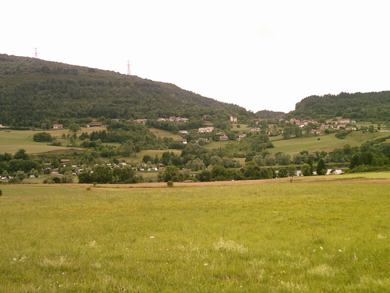
Изернор (Izernore, Izernore)
- коммуна во Франции
 Hiking in Изернор
Izernore, located in the Ain department of the Auvergne-Rhône-Alpes region in eastern France, offers a beautiful environment for hiking enthusiasts. The area is characterized by its stunning natural landscapes, including rolling hills, forests, and views of the surrounding mountains. Here are some key points for hiking in Izernore:
Hiking Trails
- Variety of Trails: Izernore and its neighboring areas feature a range of hiking trails suitable for different skill levels, from gentle walks to more challenging hikes.
- Scenic Routes: Many trails offer breathtaking views of the Jura Mountains and the Bugey region, making for picturesque hiking experiences.
- Local Nature: Hikers can enjoy diverse flora and fauna, particularly in the surrounding natural parks.
Points of Interest
- Historic Sites: Some trails may lead you to historical landmarks or traditional villages, giving you a cultural experience alongside nature.
- Gorges de la Flumen: This area, not far from Izernore, offers dramatic landscapes and is a great spot for photography and exploration.
Hiking Tips
- Check the Weather: Weather conditions can change, so be sure to check forecasts and prepare accordingly.
- Bring Essentials: Carry enough water, snacks, a map, and a first-aid kit. Good hiking boots are also essential.
- Respect Nature: Follow Leave No Trace principles to protect the environment.
Accessibility
- Getting There: Izernore is accessible by car or public transport from nearby larger towns. Check local transport for the best routes.
- Local Guides: If you're unfamiliar with the area, consider hiring a local guide for a more enriching experience.
Best Time to Hike
- Spring and Autumn: These seasons typically provide the most comfortable temperatures and beautiful scenery, as wildflowers bloom or leaves change color.
Always ensure to inform someone about your hiking plans, especially if you plan to venture into less-traveled trails. Enjoy your hiking adventure in Izernore!
- Страна:

- Почтовый код: 01580
- Координаты: 46° 13' 14" N, 5° 33' 14" E


- GPS треки (wikiloc): [Ссылка]
- Площадь: 20.86 кв.км
- Население: 2275
- Веб сайт: http://www.izernore.fr
- Википедия русская: wiki(ru)
- Википедия английская: wiki(en)
- Википедия национальная: wiki(fr)
- Хранилище Wikidata: Wikidata: Q242639
- Катеория в википедии: [Ссылка]
- Карты в википедии: [Ссылка]
- код Freebase: [/m/0815y1]
- код Freebase: [/m/0815y1]
- код GeoNames: Альт: [3012604]
- код GeoNames: Альт: [3012604]
- номер SIREN: [210101929]
- номер SIREN: [210101929]
- код VIAF: Альт: [313429396]
- код VIAF: Альт: [313429396]
- код муниципалитета INSEE: 01192
- код муниципалитета INSEE: 01192
Граничит с регионами:

Нюрьё-Волонья
- коммуна во Франции
Hiking in Нюрьё-Волонья
Nurieux-Volognat is a charming commune located in the Ain department in the Auvergne-Rhône-Alpes region of France. Nestled in the foothills of the Jura Mountains, it offers a variety of hiking opportunities with stunning natural landscapes, diverse flora, and fauna....
- Страна:
- Почтовый код: 01460
- Координаты: 46° 10' 49" N, 5° 31' 19" E
- GPS треки (wikiloc): [Ссылка]
- Площадь: 19.34 кв.км
- Население: 1028
- Веб сайт: [Ссылка]

Монреаль-ла-Клюз
- коммуна во Франции
Hiking in Монреаль-ла-Клюз
Montréal-la-Cluse, located in the Ain department of the Auvergne-Rhône-Alpes region in eastern France, offers an excellent environment for hiking enthusiasts. Nestled at the foot of the Jura Mountains, it boasts beautiful landscapes, rich biodiversity, and numerous trails that cater to various skill levels. Here are some highlights of hiking in the area:...
- Страна:
- Почтовый код: 01460
- Координаты: 46° 11' 12" N, 5° 34' 15" E
- GPS треки (wikiloc): [Ссылка]
- Высота над уровнем моря: 960 м m
- Площадь: 12.83 кв.км
- Население: 3409
- Веб сайт: [Ссылка]

Мартинья
- коммуна во Франции
Hiking in Мартинья
Martignat is a charming village located in the Ain department of the Auvergne-Rhône-Alpes region in southeastern France. It's surrounded by beautiful landscapes and offers a variety of hiking options for nature lovers and outdoor enthusiasts....
- Страна:
- Почтовый код: 01100
- Координаты: 46° 12' 34" N, 5° 36' 32" E
- GPS треки (wikiloc): [Ссылка]
- Площадь: 13.25 кв.км
- Население: 1600
- Веб сайт: [Ссылка]
Матафлон-Гранж
- коммуна во Франции
Hiking in Матафлон-Гранж
Matafelon-Granges is a commune in the Ain department in the Auvergne-Rhône-Alpes region of France. Nestled in the beautiful countryside, it offers various hiking opportunities for nature enthusiasts, with picturesque landscapes and charming local scenery....
- Страна:
- Почтовый код: 01580
- Координаты: 46° 15' 40" N, 5° 33' 14" E
- GPS треки (wikiloc): [Ссылка]
- Площадь: 21.54 кв.км
- Население: 647

Груасья
- коммуна во Франции
Hiking in Груасья
Groissiat is a charming village located in the Ain department of the Auvergne-Rhône-Alpes region in eastern France. While it may not be as widely known as some of the larger hiking destinations, it offers beautiful natural surroundings that can be appealing for those looking to escape into nature....
- Страна:
- Почтовый код: 01100
- Координаты: 46° 13' 45" N, 5° 36' 45" E
- GPS треки (wikiloc): [Ссылка]
- Площадь: 6.32 кв.км
- Население: 1213
- Веб сайт: [Ссылка]

Жеоврессе
- коммуна во Франции
Hiking in Жеоврессе
Géovreisset is a charming commune located in the Jura department of France, known for its natural beauty and outdoor activities. Hiking in this area offers a variety of scenic trails that cater to different skill levels, ranging from easy walks to more challenging hikes....
- Страна:
- Почтовый код: 01100
- Координаты: 46° 15' 22" N, 5° 37' 4" E
- GPS треки (wikiloc): [Ссылка]
- Площадь: 3.31 кв.км
- Население: 909
- Веб сайт: [Ссылка]

Беар-Жеовресья
- коммуна во Франции
Hiking in Беар-Жеовресья
Béard-Géovreissiat is a charming commune located in the Ain department in the Auvergne-Rhône-Alpes region of France. This area is known for its beautiful natural landscapes, making it a great spot for hiking enthusiasts....
- Страна:
- Почтовый код: 01460
- Координаты: 46° 11' 23" N, 5° 33' 25" E
- GPS треки (wikiloc): [Ссылка]
- Площадь: 4.69 кв.км
- Население: 1026
- Веб сайт: [Ссылка]
Сонтонна-ла-Монтань
- коммуна во Франции
Hiking in Сонтонна-ла-Монтань
Sonthonnax-la-Montagne is a charming commune in the Ain department of the Auvergne-Rhône-Alpes region in France. Nestled in the countryside, it offers a variety of scenic hiking opportunities that showcase the natural beauty of the area....
- Страна:
- Почтовый код: 01580
- Координаты: 46° 13' 59" N, 5° 31' 27" E
- GPS треки (wikiloc): [Ссылка]
- Площадь: 14.14 кв.км
- Население: 321
- Веб сайт: [Ссылка]
Самонья
- коммуна во Франции
Hiking in Самонья
It seems like there may be a misunderstanding in the name "Samognat," as it does not correspond to a well-known hiking destination or region. If you meant a different location or if Samognat is a lesser-known local area, I would recommend checking local hiking resources or tourism websites for that particular region....
- Страна:
- Почтовый код: 01580
- Координаты: 46° 15' 28" N, 5° 34' 34" E
- GPS треки (wikiloc): [Ссылка]
- Площадь: 14.01 кв.км
- Население: 660
- Веб сайт: [Ссылка]