Сонтонна-ла-Монтань (Sonthonnax-la-Montagne, Sonthonnax-la-Montagne)
- коммуна во Франции
 Hiking in Сонтонна-ла-Монтань
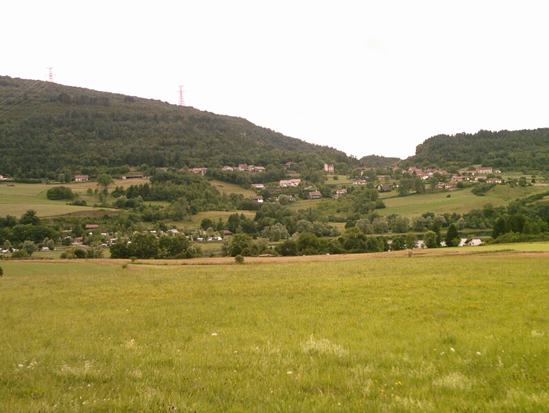
Sonthonnax-la-Montagne is a charming commune in the Ain department of the Auvergne-Rhône-Alpes region in France. Nestled in the countryside, it offers a variety of scenic hiking opportunities that showcase the natural beauty of the area.
Hiking Trails
-
Local Trails: The region is characterized by rolling hills, forests, and fields, providing numerous local trails for varying skill levels. Be sure to check local maps or guides for trail specifics.
-
Through Monts Jura: Although Sonthonnax-la-Montagne is not directly in the Monts Jura range, it is relatively close to this mountainous area, which offers more rugged terrain and breathtaking views. Trails in Monts Jura are suitable for hikers looking for a challenge.
-
GR Routes: There may be long-distance hiking routes (GR routes) nearby that lead hikers through picturesque landscapes and villages. These routes are well-marked and can provide multi-day hiking experiences.
Tips for Hiking
- Season: Spring and early autumn are ideal for hiking in this region, as the weather is generally mild and the trails are less crowded.
- Preparation: Ensure you carry enough water, snacks, and a map or GPS device. Check weather forecasts before heading out.
- Wildlife: The area may host a variety of wildlife and flora, so keep an eye out for local species and respect the natural environment.
- Local Culture: Take time to explore the local villages and engage with the culture. Enjoy regional cuisine and local traditions.
Safety Precautions
- Be aware of your surroundings and always let someone know your hiking plans.
- Familiarize yourself with the trail difficulty and your own fitness level before setting out.
- Weather conditions can change rapidly, particularly in hilly or mountainous regions, so be prepared for sudden changes.
Hiking in and around Sonthonnax-la-Montagne can provide a wonderful experience that combines physical activity with exploration of beautiful landscapes and local culture. Whether for a casual walk or a more challenging hike, it's an area rich in natural beauty and opportunities for outdoor enthusiasts.
- Страна:

- Почтовый код: 01580
- Координаты: 46° 13' 59" N, 5° 31' 27" E


- GPS треки (wikiloc): [Ссылка]
- Площадь: 14.14 кв.км
- Население: 321
- Веб сайт: http://sonthonnax-la-montagne.fr
- Википедия русская: wiki(ru)
- Википедия английская: wiki(en)
- Википедия национальная: wiki(fr)
- Хранилище Wikidata: Wikidata: Q275801
- Катеория в википедии: [Ссылка]
- Карты в википедии: [Ссылка]
- код Freebase: [/m/03m59dk]
- код Freebase: [/m/03m59dk]
- код GeoNames: Альт: [2974239]
- код GeoNames: Альт: [2974239]
- номер SIREN: [210104105]
- номер SIREN: [210104105]
- код муниципалитета INSEE: 01410
- код муниципалитета INSEE: 01410
Граничит с регионами:

Болозон
- коммуна во Франции
Hiking in Болозон
Bolozon, located in the Jura region of France, is known for its stunning landscapes and natural beauty, making it an ideal destination for hiking enthusiasts. Here’s what you can expect when hiking in Bolozon:...
- Страна:
- Почтовый код: 01450
- Координаты: 46° 11' 34" N, 5° 28' 28" E
- GPS треки (wikiloc): [Ссылка]
- Площадь: 4.92 кв.км
- Население: 89

Изернор
- коммуна во Франции
Hiking in Изернор
Izernore, located in the Ain department of the Auvergne-Rhône-Alpes region in eastern France, offers a beautiful environment for hiking enthusiasts. The area is characterized by its stunning natural landscapes, including rolling hills, forests, and views of the surrounding mountains. Here are some key points for hiking in Izernore:...
- Страна:
- Почтовый код: 01580
- Координаты: 46° 13' 14" N, 5° 33' 14" E
- GPS треки (wikiloc): [Ссылка]
- Площадь: 20.86 кв.км
- Население: 2275
- Веб сайт: [Ссылка]

Нюрьё-Волонья
- коммуна во Франции
Hiking in Нюрьё-Волонья
Nurieux-Volognat is a charming commune located in the Ain department in the Auvergne-Rhône-Alpes region of France. Nestled in the foothills of the Jura Mountains, it offers a variety of hiking opportunities with stunning natural landscapes, diverse flora, and fauna....
- Страна:
- Почтовый код: 01460
- Координаты: 46° 10' 49" N, 5° 31' 19" E
- GPS треки (wikiloc): [Ссылка]
- Площадь: 19.34 кв.км
- Население: 1028
- Веб сайт: [Ссылка]
Матафлон-Гранж
- коммуна во Франции
Hiking in Матафлон-Гранж
Matafelon-Granges is a commune in the Ain department in the Auvergne-Rhône-Alpes region of France. Nestled in the beautiful countryside, it offers various hiking opportunities for nature enthusiasts, with picturesque landscapes and charming local scenery....
- Страна:
- Почтовый код: 01580
- Координаты: 46° 15' 40" N, 5° 33' 14" E
- GPS треки (wikiloc): [Ссылка]
- Площадь: 21.54 кв.км
- Население: 647

Лейсар
- коммуна во Франции
Hiking in Лейсар
Leyssard may not be a widely recognized hiking destination, so it might be useful to clarify if you're referring to a specific area or if there's a local name you're using for a location....
- Страна:
- Почтовый код: 01450
- Координаты: 46° 9' 21" N, 5° 28' 33" E
- GPS треки (wikiloc): [Ссылка]
- Площадь: 9.13 кв.км
- Население: 154