.JPG)
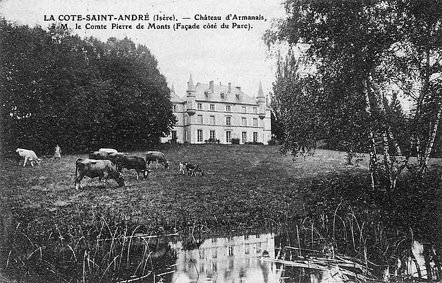
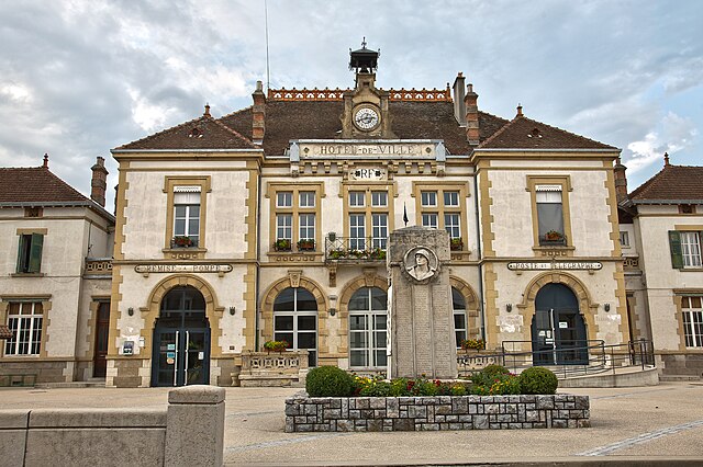
Ла-Кот-Сент-Андре (La Côte-Saint-André, La Côte-Saint-André)

- коммуна во Франции
 Hiking in Ла-Кот-Сент-Андре
La Côte-Saint-André is a charming commune located in the Isère department in the Auvergne-Rhône-Alpes region of southeastern France. It offers beautiful landscapes and a variety of hiking opportunities, making it a great destination for outdoor enthusiasts. Here are some highlights about hiking in and around La Côte-Saint-André:
Trails and Scenery
-
Local Trails: The region provides numerous walking and hiking trails that range from easy to moderate difficulty. You can expect to find well-marked paths that often go through picturesque countryside, vineyards, and forests.
-
Nearby Nature Reserves: Consider exploring the nearby nature reserves and regional parks which offer additional hiking opportunities. The Parc Naturel Régional de la Chartreuse, located to the northeast, boasts stunning mountain scenery and numerous trails.
-
Historical Significance: While hiking, you may encounter historical sites, including remnants of rustic farms, chapels, and even ancient Roman remains, all set against the backdrop of the beautiful landscape.
Suggested Hikes
-
Mont Granier: A classic hiking destination near La Côte-Saint-André, offering stunning views of the surrounding valleys and a more challenging trek for experienced hikers.
-
Les Saisies: A slightly further option, but worth it for its panoramic views and diverse trails.
-
Isère River Trails: Follow parts of the Isère River for a more leisurely hike with opportunities for birdwatching and enjoying the river's ecosystems.
Tips for Hiking in the Region
-
Check the Weather: Be mindful of the local weather conditions, especially in mountainous areas where the weather can change rapidly.
-
Bring Snacks and Water: Always carry sufficient water and snacks on any hike, as amenities may be limited on the trails.
-
Appropriate Gear: Wear appropriate hiking shoes and clothing suited for the terrain and weather conditions.
-
Respect Nature: Follow Leave No Trace principles to preserve the natural beauty of the area.
-
Local Guides: Consider joining guided hikes if you prefer more structured experiences or want to learn more about the ecology and history of the area.
Conclusion
Hiking in La Côte-Saint-André offers a delightful combination of natural beauty, outdoor adventure, and cultural exploration. Whether you're a beginner or an experienced hiker, the region has something to offer everyone. Enjoy your hikes and take the time to appreciate the stunning landscapes and warm hospitality of the area!
- Страна:

- Почтовый код: 38260
- Координаты: 45° 23' 37" N, 5° 15' 38" E


- GPS треки (wikiloc): [Ссылка]
- Площадь: 27.93 кв.км
- Население: 4745
- Веб сайт: http://www.lacotesaintandre.fr
- Википедия русская: wiki(ru)
- Википедия английская: wiki(en)
- Википедия национальная: wiki(fr)
- Хранилище Wikidata: Wikidata: Q864123
- Катеория в википедии: [Ссылка]
- код Freebase: [/m/02x0chs]
- код GeoNames: Альт: [6455931]
- номер SIREN: [213801301]
- код BNF: [152579530]
- код VIAF: Альт: [239241610]
- код тезауруса PACTOLS: [pcrtqyiy5zpAjP]
- место в MusicBrainz: [d427e247-565b-40a5-9195-b39a85b4502f]
- код муниципалитета INSEE: 38130
Граничит с регионами:


Коммель
- коммуна во Франции
Hiking in Коммель
Commelle is a lesser-known hiking destination, but if you're referring to a specific region or trail system, I would need a bit more clarity, as there may be multiple locations with similar names around the world....
- Страна:
- Почтовый код: 38260
- Координаты: 45° 25' 41" N, 5° 13' 35" E
- GPS треки (wikiloc): [Ссылка]
- Площадь: 14.04 кв.км
- Население: 927
- Веб сайт: [Ссылка]

Бальбен
- коммуна во Франции
Hiking in Бальбен
It seems like you might be referring to a specific location, but "Balbins" isn't widely recognized as a hiking destination. If you meant a different place, please clarify the name or provide more details....
- Страна:
- Почтовый код: 38260
- Координаты: 45° 23' 54" N, 5° 12' 51" E
- GPS треки (wikiloc): [Ссылка]
- Площадь: 7.26 кв.км
- Население: 432
- Веб сайт: [Ссылка]

Сен-Симеон-де-Бресьё
- коммуна во Франции
Hiking in Сен-Симеон-де-Бресьё
Saint-Siméon-de-Bressieux is a charming village located in the Isère department in the Auvergne-Rhône-Alpes region of France. The surrounding area offers stunning natural landscapes, making it an excellent spot for hiking enthusiasts....
- Страна:
- Почтовый код: 38870
- Координаты: 45° 19' 42" N, 5° 15' 42" E
- GPS треки (wikiloc): [Ссылка]
- Площадь: 18.79 кв.км
- Население: 2876
- Веб сайт: [Ссылка]


Нантуэн
- коммуна во Франции
Hiking in Нантуэн
Nantoin, a beautiful area often associated with the scenic landscapes of the Chartreuse National Park in France, is a fantastic destination for hiking enthusiasts. Here are some key points to consider if you're planning a hike in and around Nantoin:...
- Страна:
- Почтовый код: 38260
- Координаты: 45° 26' 8" N, 5° 16' 9" E
- GPS треки (wikiloc): [Ссылка]
- Высота над уровнем моря: 609 м m
- Площадь: 9.5 кв.км
- Население: 464
- Веб сайт: [Ссылка]

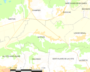
Мотье
- коммуна во Франции
Hiking in Мотье
Mottier, located in the beautiful area of Isère in the French Alps, offers a variety of hiking opportunities that cater to different skill levels and preferences. The surrounding landscape is characterized by stunning mountain views, diverse flora and fauna, and picturesque trails that are perfect for both day hikes and longer excursions....
- Страна:
- Почтовый код: 38260
- Координаты: 45° 25' 8" N, 5° 19' 2" E
- GPS треки (wikiloc): [Ссылка]
- Площадь: 10.72 кв.км
- Население: 690
- Веб сайт: [Ссылка]


Орнасьё
- коммуна во Франции
Hiking in Орнасьё
Ornacieux is a charming village located in the Rhône-Alpes region of France, surrounded by beautiful natural landscapes, making it a great destination for hiking enthusiasts. The area offers a variety of trails that cater to different skill levels, from leisurely walks to more challenging hikes....
- Страна:
- Почтовый код: 38260
- Координаты: 45° 24' 2" N, 5° 12' 40" E
- GPS треки (wikiloc): [Ссылка]
- Площадь: 4.89 кв.км
- Население: 416

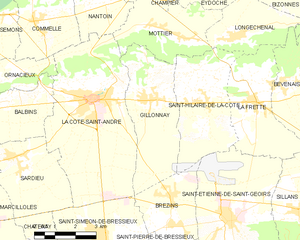
Жийонне
- коммуна во Франции
Hiking in Жийонне
Gillonnay is a charming village located in the Isère department of the Auvergne-Rhône-Alpes region in southeastern France. The area offers a variety of hiking opportunities, ranging from easy walks to more challenging trails, all set against a backdrop of picturesque landscapes and natural beauty....
- Страна:
- Почтовый код: 38260
- Координаты: 45° 23' 34" N, 5° 17' 50" E
- GPS треки (wikiloc): [Ссылка]
- Площадь: 14.29 кв.км
- Население: 1014


Сардьё
- коммуна во Франции
Hiking in Сардьё
Sardieu is a beautiful destination for hiking, located in the Isère department of France, near the foothills of the Alps. This region is known for its scenic landscapes, diverse terrain, and beautiful views, making it a great spot for outdoor enthusiasts....
- Страна:
- Почтовый код: 38260
- Координаты: 45° 22' 9" N, 5° 12' 43" E
- GPS треки (wikiloc): [Ссылка]
- Высота над уровнем моря: 358 м m
- Площадь: 11.2 кв.км
- Население: 1097
- Веб сайт: [Ссылка]