Ле-Бур-д'Уазан (Le Bourg-d'Oisans, Le Bourg-d'Oisans)

- коммуна во Франции
 Hiking in Ле-Бур-д'Уазан
Le Bourg-d'Oisans is a charming commune located in the French Alps, nestled between the Oisans mountain range and the breathtaking Ecrins National Park. It's an excellent base for those who enjoy hiking, as it offers a variety of trails suitable for all experience levels, from beginner to advanced.
Hiking Highlights
-
Diverse Trails: The region boasts numerous trails that vary in difficulty, allowing hikers to explore the stunning landscapes of the Alps. You can find everything from gentle walks along the valley to challenging ascents that lead to high mountain passes.
-
Scenic Landscapes: The trails often feature magnificent views of surrounding peaks, alpine meadows, and glacial lakes. The breathtaking scenery is particularly stunning during spring and summer when wildflowers are in bloom.
-
Prominent Hikes:
- Alpe d'Huez: Just a short distance from Le Bourg-d'Oisans, this area offers iconic hikes, including the ascent to the Pic Blanc, where you can enjoy panoramic views from 3,330 meters.
- Lac de l'Eau d'Olle: A beautiful hike leading to an alpine lake, which is great for a picnic and offers a serene atmosphere.
- Col du Sabot: For more experienced hikers, this route offers a rewarding challenge along with breathtaking views from the pass.
-
Biking and Accessibility: Le Bourg-d'Oisans is also a hub for cycling enthusiasts, particularly during the Tour de France. Many hiking and biking trails intersect, providing even more options for outdoor activities.
-
Cultural Experiences: In addition to hiking, the area is rich in culture and history. You can explore traditional Alpine villages, sample local cuisine, and visit historic sites related to the region's mining past.
Tips for Hiking in the Area
- Weather Awareness: The weather can change rapidly in the mountains, so be prepared with appropriate gear, including rain jackets, warm clothing, and sun protection.
- Hydration and Snacks: Always carry enough water and some snacks to maintain energy levels during hikes.
- Maps and Guided Tours: Consider using local maps or hiring a guide, especially for more challenging hikes, to ensure you find the best paths and stay safe.
- Wildlife Respect: The region is home to diverse wildlife. Make sure to observe animals from a distance and respect their habitats.
Seasonality
Hiking is best from late spring to early autumn, with mid-summer being peak hiking season when trails are most accessible, but be wary of crowds in popular areas during this time. Always check local conditions before planning your hike, especially in spring and autumn when snowfall can affect higher trails.
Overall, Le Bourg-d'Oisans is a perfect destination for both novice and experienced hikers seeking stunning Alpine trails and breathtaking landscapes!
- Страна:

- Почтовый код: 38520
- Координаты: 45° 3' 19" N, 6° 1' 46" E


- GPS треки (wikiloc): [Ссылка]
- Площадь: 35.75 кв.км
- Население: 3239
- Веб сайт: http://www.bourgdoisans.com
- Википедия русская: wiki(ru)
- Википедия английская: wiki(en)
- Википедия национальная: wiki(fr)
- Хранилище Wikidata: Wikidata: Q244679
- Галерея изображений в википедии: [Ссылка]
- Катеория в википедии: [Ссылка]
- код Freebase: [/m/08dnpb]
- код GeoNames: Альт: [3005091]
- номер SIREN: [213800527]
- код BNF: [15257881z]
- код VIAF: Альт: [468145424573286830832]
- код тезауруса PACTOLS: [pcrtjt9vDDYGTj]
- код муниципалитета INSEE: 38052
Граничит с регионами:

Вальжуффре
- коммуна во Франции
Hiking in Вальжуффре
Valjouffrey is a beautiful and lesser-known hiking destination located in the Isère department of the Auvergne-Rhône-Alpes region in France. Nestled in the heart of the Vercors Massif, Valjouffrey offers stunning landscapes characterized by dramatic peaks, lush valleys, and serene alpine lakes, making it a perfect spot for outdoor enthusiasts....
- Страна:
- Почтовый код: 38740
- Координаты: 44° 52' 20" N, 6° 1' 52" E
- GPS треки (wikiloc): [Ссылка]
- Высота над уровнем моря: 1014 м m
- Площадь: 72.56 кв.км
- Население: 145
- Веб сайт: [Ссылка]


Ле-Перье
- коммуна во Франции
Hiking in Ле-Перье
Le Périer is a charming village located in the Isère department of the Auvergne-Rhône-Alpes region in southeastern France. It's situated near the Vercors Regional Natural Park, which offers a variety of hiking opportunities for outdoor enthusiasts....
- Страна:
- Почтовый код: 38740
- Координаты: 44° 56' 13" N, 5° 58' 24" E
- GPS треки (wikiloc): [Ссылка]
- Площадь: 47.99 кв.км
- Население: 137

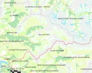
Шантлув
- коммуна во Франции
Hiking in Шантлув
Chantelouve, located in the Isère department of France, is a wonderful destination for hiking enthusiasts, especially those looking to explore the stunning landscapes of the French Alps. Here are some highlights and tips for hiking in this area:...
- Страна:
- Почтовый код: 38740
- Координаты: 44° 59' 2" N, 5° 58' 6" E
- GPS треки (wikiloc): [Ссылка]
- Площадь: 33.41 кв.км
- Население: 80
- Веб сайт: [Ссылка]

Аллемон
- коммуна во Франции
Hiking in Аллемон
Allemont is a picturesque village located in the French Alps, specifically in the Isère department. It serves as a gateway to the Vaujany valley and nearby hiking routes in the Oisans region, making it a great base for outdoor enthusiasts. Here are some highlights and considerations for hiking in and around Allemont:...
- Страна:
- Почтовый код: 38114
- Координаты: 45° 7' 49" N, 6° 2' 15" E
- GPS треки (wikiloc): [Ссылка]
- Площадь: 44.75 кв.км
- Население: 1006
- Веб сайт: [Ссылка]

Уль
- коммуна во Франции
Hiking in Уль
Oulles is a small, picturesque village located in the French Alps, known for its stunning natural beauty and excellent hiking opportunities. Situated in the Isère department, it offers a variety of trails suitable for different skill levels, making it a great destination for both novice and experienced hikers....
- Страна:
- Почтовый код: 38520
- Координаты: 45° 4' 27" N, 5° 58' 58" E
- GPS треки (wikiloc): [Ссылка]
- Площадь: 11.01 кв.км
- Население: 9
- Веб сайт: [Ссылка]


Виллар-Реймон
- коммуна во Франции
Hiking in Виллар-Реймон
Villard-Reymond is a picturesque mountain village located in the French Alps, specifically in the Isère department. Known for its stunning scenery, the area offers a variety of hiking opportunities for all levels of experience. Here are some highlights of hiking in and around Villard-Reymond:...
- Страна:
- Почтовый код: 38520
- Координаты: 45° 2' 2" N, 6° 1' 6" E
- GPS треки (wikiloc): [Ссылка]
- Площадь: 11.21 кв.км
- Население: 43
- Веб сайт: [Ссылка]
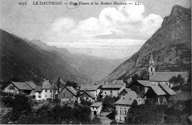

Оз (Изер)
- коммуна во Франции
Hiking in Оз (Изер)
Hiking in Oz, a charming alpine village located in the Isère department of France, offers exhilarating experiences amidst breathtaking scenery. Situated within the Grandes Rousses mountains in the French Alps, Oz is part of the Alpe d'Huez ski area, which transforms into a hiker's paradise during the summer months....
- Страна:
- Почтовый код: 38114
- Координаты: 45° 8' 27" N, 6° 3' 7" E
- GPS треки (wikiloc): [Ссылка]
- Площадь: 16.81 кв.км
- Население: 246
- Веб сайт: [Ссылка]

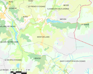
Мон-де-Лан
- коммуна во Франции
Hiking in Мон-де-Лан
Mont-de-Lans, located in the French Alps, is a scenic area that offers a variety of hiking opportunities for all levels of hikers. Situated near the famous ski resort of Les Deux Alpes, it transforms into a hiker’s paradise during the warmer months, showcasing stunning alpine landscapes, breathtaking views, and diverse flora and fauna....
- Страна:
- Почтовый код: 38860
- Координаты: 45° 2' 9" N, 6° 7' 44" E
- GPS треки (wikiloc): [Ссылка]
- Площадь: 31.66 кв.км
- Население: 1129
- Веб сайт: [Ссылка]


Веноск
- коммуна во Франции
Hiking in Веноск
Vénosc is a charming mountain village located in the French Alps, near the popular ski resort of Les Deux Alpes in the Isère department. The area offers a variety of hiking opportunities that cater to different skill levels, from leisurely walks to challenging mountain trails. Here are some highlights of hiking in Vénosc:...
- Страна:
- Почтовый код: 38520
- Координаты: 44° 59' 24" N, 6° 6' 56" E
- GPS треки (wikiloc): [Ссылка]
- Площадь: 25.06 кв.км
- Население: 765
- Веб сайт: [Ссылка]


Виллар-Нотр-Дам
- коммуна во Франции
Hiking in Виллар-Нотр-Дам
Villard-Notre-Dame is a beautiful destination located in the French Alps, specifically in the Écrins National Park. This area is renowned for its stunning alpine landscapes, rich biodiversity, and a variety of outdoor activities, including hiking....
- Страна:
- Почтовый код: 38520
- Координаты: 45° 1' 9" N, 6° 2' 38" E
- GPS треки (wikiloc): [Ссылка]
- Площадь: 14.06 кв.км
- Население: 26
- Веб сайт: [Ссылка]

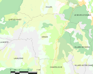
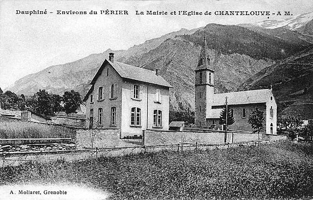
Орнон
Hiking in Орнон
Ornon is a lesser-known area that offers unique hiking opportunities, especially for those seeking a more tranquil outdoor experience. Located in the French Alps, the region is characterized by its stunning landscapes, dense forests, and diverse wildlife....
- Страна:
- Почтовый код: 38520
- Координаты: 45° 2' 28" N, 5° 58' 40" E
- GPS треки (wikiloc): [Ссылка]
- Площадь: 11.6 кв.км
- Население: 133


Ла-Гард
Hiking in Ла-Гард
La Garde is a charming commune located in the Isère department in southeastern France, nestled in the picturesque landscape of the French Alps. It's a great destination for hiking enthusiasts, offering a variety of trails that cater to different skill levels....
- Страна:
- Почтовый код: 38520
- Координаты: 45° 4' 8" N, 6° 2' 45" E
- GPS треки (wikiloc): [Ссылка]
- Высота над уровнем моря: 982 м m
- Площадь: 9.09 кв.км
- Население: 100
- Веб сайт: [Ссылка]


Ори
- коммуна во Франции
Hiking in Ори
Auris, located in the Isère department of the Auvergne-Rhône-Alpes region in France, offers stunning hiking opportunities, especially for those looking to explore the beautiful landscapes of the French Alps. Here’s a guide to hiking in Auris:...
- Страна:
- Почтовый код: 38142
- Координаты: 45° 2' 47" N, 6° 5' 12" E
- GPS треки (wikiloc): [Ссылка]
- Площадь: 11.21 кв.км
- Население: 201
- Веб сайт: [Ссылка]


Ливе-э-Гаве
- коммуна во Франции
Hiking in Ливе-э-Гаве
Livet-et-Gavet, located in the Auvergne-Rhône-Alpes region of France, is a picturesque destination for hiking enthusiasts. This area is characterized by its stunning natural landscapes, including lush forests, rivers, and mountainous terrain. Here are some highlights and tips for hiking in Livet-et-Gavet:...
- Страна:
- Почтовый код: 38220
- Координаты: 45° 5' 28" N, 5° 54' 9" E
- GPS треки (wikiloc): [Ссылка]
- Площадь: 46.54 кв.км
- Население: 1296
- Веб сайт: [Ссылка]