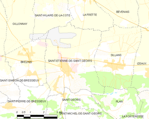
Брезен (Brézins, Brézins)

- коммуна во Франции
 Hiking in Брезен
Brézins is a small commune located in the Isère department in the Auvergne-Rhône-Alpes region of southeastern France. While it may not be one of the most popular hiking destinations, it serves as a great starting point for exploring the surrounding natural beauty of the region, including the stunning landscapes of the Chartreuse and Vercors mountains.
Hiking Opportunities:
-
Local Trails: Brézins features several local trails that allow hikers to explore the countryside. These trails often offer picturesque views of the surrounding hills, forests, and farmland.
-
Chartreuse Mountains: To the north of Brézins, the Chartreuse Mountains are known for their breathtaking scenery, with rugged peaks, deep valleys, and dense forests. Trails here vary in difficulty, catering to both beginners and experienced hikers. The Granier and Charmant Som are popular summits offering rewarding panoramic views.
-
Vercors Regional Natural Park: Located to the east, the Vercors range provides a plethora of hiking options, from easy walks suitable for families to challenging multi-day treks. The park is known for its dramatic limestone cliffs, unique flora and fauna, and historical significance.
Tips for Hiking in Brézins:
- Weather: The weather can vary significantly, so check the forecast before heading out. Spring and fall are generally the best times for hiking due to mild temperatures.
- Local Maps: It’s advisable to carry a detailed map or GPS device as some trails may not be well marked.
- Gear: Wear appropriate footwear and pack essentials such as water, snacks, a first aid kit, and sun protection.
Nearby Attractions:
- Historical Sites: Explore nearby towns with historical significance, such as Grenoble, known for its architecture and museums.
- Caves and Grottos: The region is also rich in geological wonders with several caves, particularly in the Vercors.
Overall, while Brézins itself may not be a major hiking destination, its proximity to the mountains and natural parks makes it a great base for outdoor enthusiasts looking to explore the beautiful landscapes of the Auvergne-Rhône-Alpes region.
- Страна:

- Почтовый код: 38590
- Координаты: 45° 20' 57" N, 5° 18' 24" E


- GPS треки (wikiloc): [Ссылка]
- Площадь: 8.26 кв.км
- Население: 2042
- Веб сайт: http://www.brezins.fr
- Википедия русская: wiki(ru)
- Википедия английская: wiki(en)
- Википедия национальная: wiki(fr)
- Хранилище Wikidata: Wikidata: Q1002959
- Катеория в википедии: [Ссылка]
- код Freebase: [/m/03g_6rl]
- код GeoNames: Альт: [6448737]
- номер SIREN: [213800584]
- код BNF: [152578871]
- код тезауруса PACTOLS: [pcrtrN4UvuR9vH]
- код муниципалитета INSEE: 38058
Граничит с регионами:

Сент-Этьенн-де-Сен-Жуар
- коммуна во Франции
Hiking in Сент-Этьенн-де-Сен-Жуар
Saint-Étienne-de-Saint-Geoirs, located in the Auvergne-Rhône-Alpes region of France, is surrounded by beautiful natural landscapes that are ideal for hiking enthusiasts. Here are some highlights and recommendations for hiking in this area:...
- Страна:
- Почтовый код: 38590
- Координаты: 45° 20' 20" N, 5° 20' 43" E
- GPS треки (wikiloc): [Ссылка]
- Площадь: 18.62 кв.км
- Население: 3259
- Веб сайт: [Ссылка]

Сен-Симеон-де-Бресьё
- коммуна во Франции
Hiking in Сен-Симеон-де-Бресьё
Saint-Siméon-de-Bressieux is a charming village located in the Isère department in the Auvergne-Rhône-Alpes region of France. The surrounding area offers stunning natural landscapes, making it an excellent spot for hiking enthusiasts....
- Страна:
- Почтовый код: 38870
- Координаты: 45° 19' 42" N, 5° 15' 42" E
- GPS треки (wikiloc): [Ссылка]
- Площадь: 18.79 кв.км
- Население: 2876
- Веб сайт: [Ссылка]


Сен-Пьер-де-Бресьё
- коммуна во Франции
Hiking in Сен-Пьер-де-Бресьё
Saint-Pierre-de-Bressieux is a charming commune located in the Isère department of France, nestled in the picturesque region of Auvergne-Rhône-Alpes. Hiking around this area offers beautiful landscapes, varying terrains, and opportunities to explore the local flora and fauna....
- Страна:
- Почтовый код: 38870
- Координаты: 45° 18' 56" N, 5° 17' 7" E
- GPS треки (wikiloc): [Ссылка]
- Площадь: 23.08 кв.км
- Население: 766
- Веб сайт: [Ссылка]


Сент-Илер-де-ла-Кот
- коммуна во Франции
Hiking in Сент-Илер-де-ла-Кот
Saint-Hilaire-de-la-Côte is a picturesque mountain village located in the Isère department of the Auvergne-Rhône-Alpes region in southeastern France. It offers a variety of hiking opportunities, attracting both casual walkers and avid trekkers....
- Страна:
- Почтовый код: 38260
- Координаты: 45° 23' 26" N, 5° 19' 38" E
- GPS треки (wikiloc): [Ссылка]
- Площадь: 13.75 кв.км
- Население: 1431
- Веб сайт: [Ссылка]

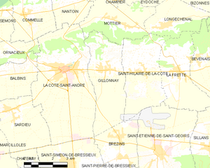
Жийонне
- коммуна во Франции
Hiking in Жийонне
Gillonnay is a charming village located in the Isère department of the Auvergne-Rhône-Alpes region in southeastern France. The area offers a variety of hiking opportunities, ranging from easy walks to more challenging trails, all set against a backdrop of picturesque landscapes and natural beauty....
- Страна:
- Почтовый код: 38260
- Координаты: 45° 23' 34" N, 5° 17' 50" E
- GPS треки (wikiloc): [Ссылка]
- Площадь: 14.29 кв.км
- Население: 1014