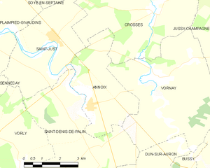
Annoix (Annoix)
- commune in Cher, France
- Country:

- Postal Code: 18340
- Coordinates: 46° 57' 37" N, 2° 32' 3" E


- GPS tracks (wikiloc): [Link]
- Area: 11.79 sq km
- Population: 234
- Wikipedia en: wiki(en)
- Wikipedia: wiki(fr)
- Wikidata storage: Wikidata: Q1406166
- Wikipedia Commons Category: [Link]
- Freebase ID: [/m/03mfc09]
- GeoNames ID: Alt: [6452168]
- SIREN number: [211800065]
- BnF ID: [152493528]
- INSEE municipality code: 18006
Shares border with regions:


Crosses
- commune in Cher, France
- Country:

- Postal Code: 18340
- Coordinates: 47° 0' 39" N, 2° 34' 54" E


- GPS tracks (wikiloc): [Link]
- Area: 26.49 sq km
- Population: 380
- Web site: [Link]


Saint-Denis-de-Palin
- commune in Cher, France
- Country:

- Postal Code: 18130
- Coordinates: 46° 56' 23" N, 2° 32' 19" E


- GPS tracks (wikiloc): [Link]
- Area: 30.51 sq km
- Population: 329
- Web site: [Link]
Vornay
- commune in Cher, France
- Country:

- Postal Code: 18130
- Coordinates: 46° 58' 23" N, 2° 35' 0" E


- GPS tracks (wikiloc): [Link]
- Area: 26.35 sq km
- Population: 597
- Web site: [Link]
Saint-Just
- commune in Cher, France
- Country:

- Postal Code: 18340
- Coordinates: 46° 59' 35" N, 2° 30' 32" E


- GPS tracks (wikiloc): [Link]
- Area: 15.12 sq km
- Population: 629
