canton of Levet (canton de Levet)
- canton of France (until March 2015)
- Country:

- Capital: Levet
- Coordinates: 46° 55' 36" N, 2° 24' 34" E


- GPS tracks (wikiloc): [Link]
- Wikipedia en: wiki(en)
- Wikipedia: wiki(fr)
- Wikidata storage: Wikidata: Q593906
- Freebase ID: [/m/05s_rnx]
- INSEE canton code: [1817]
Includes regions:
Soye-en-Septaine
- commune in Cher, France
- Country:
- Postal Code: 18340
- Coordinates: 47° 1' 36" N, 2° 29' 21" E
- GPS tracks (wikiloc): [Link]
- Area: 18.57 sq km
- Population: 578

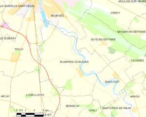
Plaimpied-Givaudins
- commune in Cher, France
- Country:
- Postal Code: 18340
- Coordinates: 46° 59' 55" N, 2° 27' 15" E
- GPS tracks (wikiloc): [Link]
- Area: 40.51 sq km
- Population: 1959
Sainte-Lunaise
- commune in Cher, France
- Country:
- Postal Code: 18340
- Coordinates: 46° 55' 14" N, 2° 20' 54" E
- GPS tracks (wikiloc): [Link]
- Area: 13.95 sq km
- Population: 18
Saint-Caprais
- commune in Cher, France
- Country:
- Postal Code: 18400
- Coordinates: 46° 58' 6" N, 2° 17' 36" E
- GPS tracks (wikiloc): [Link]
- Area: 14.42 sq km
- Population: 772

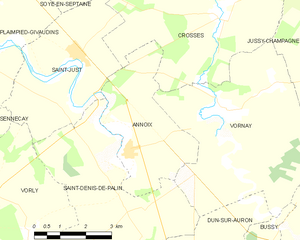
Annoix
- commune in Cher, France
- Country:
- Postal Code: 18340
- Coordinates: 46° 57' 37" N, 2° 32' 3" E
- GPS tracks (wikiloc): [Link]
- Area: 11.79 sq km
- Population: 234

Trouy
- commune in Cher, France
- Country:
- Postal Code: 18570
- Coordinates: 47° 0' 37" N, 2° 21' 28" E
- GPS tracks (wikiloc): [Link]
- Area: 23.19 sq km
- Population: 3942
- Web site: [Link]


Vorly
- commune in Cher, France
- Country:
- Postal Code: 18340
- Coordinates: 46° 56' 43" N, 2° 27' 54" E
- GPS tracks (wikiloc): [Link]
- Area: 18.84 sq km
- Population: 237
Saint-Just
- commune in Cher, France
- Country:
- Postal Code: 18340
- Coordinates: 46° 59' 35" N, 2° 30' 32" E
- GPS tracks (wikiloc): [Link]
- Area: 15.12 sq km
- Population: 629
Lapan
- commune in Cher, France
- Country:
- Postal Code: 18340
- Coordinates: 46° 55' 24" N, 2° 17' 59" E
- GPS tracks (wikiloc): [Link]
- Area: 10.5 sq km
- Population: 200
Lissay-Lochy
- commune in Cher, France
- Country:
- Postal Code: 18340
- Coordinates: 46° 58' 20" N, 2° 24' 24" E
- GPS tracks (wikiloc): [Link]
- Area: 22.06 sq km
- Population: 227
- Web site: [Link]


Senneçay
- commune in Cher, France
- Country:
- Postal Code: 18340
- Coordinates: 46° 57' 4" N, 2° 26' 14" E
- GPS tracks (wikiloc): [Link]
- Area: 14.47 sq km
- Population: 462
Levet
- commune in Cher, France
- Country:
- Postal Code: 18340
- Coordinates: 46° 55' 33" N, 2° 24' 31" E
- GPS tracks (wikiloc): [Link]
- Area: 25.97 sq km
- Population: 1403

Arçay
- commune in Cher, France
- Country:
- Postal Code: 18340
- Coordinates: 46° 56' 54" N, 2° 20' 25" E
- GPS tracks (wikiloc): [Link]
- Area: 18.32 sq km
- Population: 516