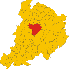
Anzola dell'Emilia (Anzola dell'Emilia)
.svg)
- Italian comune
 Hiking in Anzola dell'Emilia
Anzola dell'Emilia is a charming town located in the Emilia-Romagna region of Italy, known for its rich cultural heritage and beautiful landscapes. While it may not be as famous for hiking as some of the more mountainous regions of Italy, there are certainly opportunities for outdoor activities in and around Anzola dell'Emilia.
Hiking Opportunities:
-
Local Trails: Explore the smaller, lesser-known paths around Anzola dell'Emilia. These can include agricultural routes that pass through fields, vineyards, and charming countryside views. Always be mindful of private property and respect local regulations while hiking.
-
Parco dei Gessi Bolognesi e Calanchi dell'Abbadessa: Just a short distance from Anzola dell'Emilia, this park offers various hiking trails through unique geological formations, including gorges and calanques. The trails vary in difficulty and provide breathtaking views of the surrounding landscape.
-
Bologna Hills: The nearby hills of Bologna, which are easily accessible, offer numerous hiking paths with varying degrees of difficulty. You can enjoy panoramic views of the city and the surrounding countryside.
-
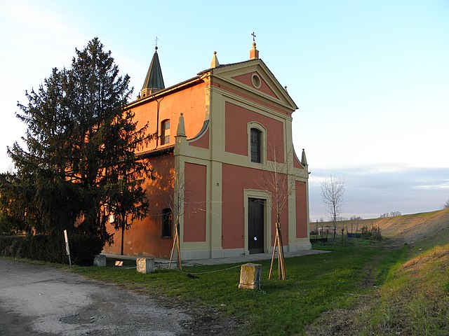
Historical Trails: Some routes may lead you to historical landmarks, churches, and old villages. Incorporating cultural exploration into your hike adds an extra layer of experience.
Tips for Hiking in Anzola dell'Emilia:
- Prepare for Weather: The weather in Emilia-Romagna can change rapidly, so check forecasts and dress in layers.
- Stay Hydrated: Always carry enough water, especially if you’re hiking on warmer days.
- Local Information: It may be helpful to visit local tourist information centers for maps, guidance on trails, and any safety updates.
- Respect Nature: Follow the Leave No Trace principles to help preserve the natural beauty of the area.
- Safety: If you're unfamiliar with the area, consider hiking with someone knowledgeable or join a guided tour.
Conclusion:
While hiking in Anzola dell'Emilia may not be as extensive as in other regions of Italy, the area offers beautiful, peaceful trails where you can enjoy nature and local culture. Whether you're a seasoned hiker or a novice, there are opportunities to explore the landscape and immerse yourself in the scenic beauty of the Emilia-Romagna region. Happy hiking!
- Country:

- Postal Code: 40011
- Local Dialing Code: 051
- Licence Plate Code: BO
- Coordinates: 44° 32' 50" N, 11° 11' 44" E


- GPS tracks (wikiloc): [Link]
- AboveSeaLevel: 38 м m
- Area: 36.6 sq km
- Population: 12310
- Web site: http://www.comune.anzoladellemilia.bo.it
- Wikipedia en: wiki(en)
- Wikipedia: wiki(it)
- Wikidata storage: Wikidata: Q94493
- Wikipedia Commons Category: [Link]
- Freebase ID: [/m/0gkg_5]
- GeoNames ID: Alt: [6538461]
- VIAF ID: Alt: [305234300]
- OSM relation ID: [43270]
- UN/LOCODE: [ITADE]
- Digital Atlas of the Roman Empire ID: [22352]
- ISTAT ID: 037001
- Italian cadastre code: A324
Shares border with regions:


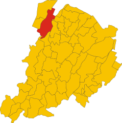
Castelfranco Emilia
- Italian comune
Hiking in Castelfranco Emilia
Castelfranco Emilia, located in the Emilia-Romagna region of northern Italy, is not only known for its beautiful architecture and history but also for its scenic landscapes and opportunities for hiking. Although it may not be as famous for hiking as some Italian regions, there are still several trails and natural spots nearby that can offer a charming experience for hikers....
- Country:
- Postal Code: 41013
- Local Dialing Code: 059
- Licence Plate Code: MO
- Coordinates: 44° 35' 48" N, 11° 3' 10" E
- GPS tracks (wikiloc): [Link]
- AboveSeaLevel: 42 м m
- Area: 102.51 sq km
- Population: 32894
- Web site: [Link]
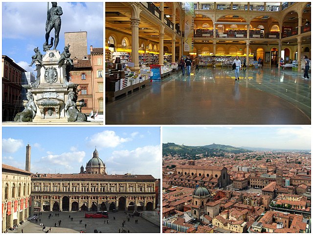
Bologna
- city in Emilia-Romagna, Italy
Hiking in Bologna
Bologna, known for its rich culture, gastronomy, and history, also offers some lovely opportunities for hiking and outdoor activities in its surrounding areas. Here's a guide to hiking in and around Bologna:...
- Country:
- Postal Code: 40121–40141
- Local Dialing Code: 051
- Licence Plate Code: BO
- Coordinates: 44° 29' 38" N, 11° 20' 34" E
- GPS tracks (wikiloc): [Link]
- AboveSeaLevel: 54 м m
- Area: 140.86 sq km
- Population: 388367
- Web site: [Link]


Calderara di Reno
- Italian comune
Hiking in Calderara di Reno
Calderara di Reno is a municipality located in the province of Bologna, Italy. While the area itself may not be as widely recognized for hiking as some of the larger national parks or mountainous regions, it offers some opportunities for outdoor enthusiasts. Here’s what you can expect when hiking in and around Calderara di Reno:...
- Country:
- Postal Code: 40012
- Local Dialing Code: 051
- Licence Plate Code: BO
- Coordinates: 44° 33' 50" N, 11° 16' 19" E
- GPS tracks (wikiloc): [Link]
- AboveSeaLevel: 30 м m
- Area: 41.25 sq km
- Population: 13224
- Web site: [Link]
Crespellano
- Italian comune
Hiking in Crespellano
Crespellano is a charming village located in the Emilia-Romagna region of Italy, not far from Bologna. It offers several opportunities for hiking enthusiasts who want to explore the natural beauty and scenic landscapes of the surrounding area....
- Country:
- Postal Code: 40056
- Local Dialing Code: 051
- Licence Plate Code: BO
- Coordinates: 44° 30' 41" N, 11° 7' 53" E
- GPS tracks (wikiloc): [Link]
- AboveSeaLevel: 64 м m
- Area: 37.5 sq km
- Web site: [Link]

Sala Bolognese
- Italian comune
Hiking in Sala Bolognese
Sala Bolognese, located in the Emilia-Romagna region of Italy, is not a widely recognized hiking destination compared to surrounding areas. However, the region's rich landscape and proximity to larger natural attractions provide opportunities for walkers and hikers to explore....
- Country:
- Postal Code: 40010
- Local Dialing Code: 051
- Licence Plate Code: BO
- Coordinates: 44° 37' 49" N, 11° 16' 34" E
- GPS tracks (wikiloc): [Link]
- AboveSeaLevel: 25 м m
- Area: 45.64 sq km
- Population: 8372
- Web site: [Link]

San Giovanni in Persiceto
- Italian comune
Hiking in San Giovanni in Persiceto
San Giovanni in Persiceto, located in the Emilia-Romagna region of Italy, offers beautiful landscapes and scenic routes that attract hikers looking to explore the rustic charm of the area. While the town itself is known for its historical architecture and cultural heritage, the surrounding countryside provides several opportunities for hiking and outdoor activities....
- Country:
- Postal Code: 40017
- Local Dialing Code: 051
- Licence Plate Code: BO
- Coordinates: 44° 38' 27" N, 11° 11' 6" E
- GPS tracks (wikiloc): [Link]
- AboveSeaLevel: 21 м m
- Area: 114.41 sq km
- Population: 28153
- Web site: [Link]


Zola Predosa
- Italian comune
Hiking in Zola Predosa
Zola Predosa, located in the metropolitan area of Bologna in Italy, offers a variety of hiking opportunities amidst its picturesque landscapes. The area is characterized by rolling hills, vineyards, and olive groves, making it an appealing destination for outdoor enthusiasts. Here are some key points about hiking in Zola Predosa:...
- Country:
- Postal Code: 40069
- Local Dialing Code: 051
- Licence Plate Code: BO
- Coordinates: 44° 29' 18" N, 11° 13' 5" E
- GPS tracks (wikiloc): [Link]
- AboveSeaLevel: 74 м m
- Area: 37 sq km
- Population: 15105
- Web site: [Link]