
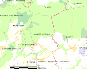
Saulnot (Saulnot)

- commune in Haute-Saône, France
 Hiking in Saulnot
Saulnot is a quaint village located in the Bourgogne-Franche-Comté region of France, surrounded by beautiful natural landscapes that make it an appealing destination for hiking enthusiasts. The area offers a mix of scenic trails that cater to various skill levels, from leisurely walks to more challenging hikes.
Hiking Highlights in Saulnot:
-
Scenic Trails: The region boasts well-marked trails that weave through stunning countryside, including forests, meadows, and hills. These paths often provide picturesque views of the surrounding Jura Mountains and local wildlife.
-
Nature Reserves: The nearby nature reserves and parks are perfect for those looking to explore diverse ecosystems. Birdwatching and spotting local flora and fauna can be highlights of your hiking experience.
-
Cultural Landmarks: Along some hiking routes, you may come across historical sites, such as ancient chapels, farms, and traditional Burgundy architecture. Incorporating these cultural elements into your hikes can enrich your experience.
-
Seasonal Hiking: Each season in Saulnot offers a unique hiking experience. Spring brings blooming wildflowers, summer provides lush greenery, autumn showcases stunning fall colors, and winter might offer serene snowy landscapes (though some trails may be less accessible).
-
Local Guides and Resources: You can often find local hiking guides and maps at the tourist office in Saulnot or nearby towns. They can provide valuable insights into the best trails and current conditions.
Tips for Hiking in Saulnot:
- Prepare Accordingly: Ensure you have suitable footwear, clothing for the weather, and enough water and snacks.
- Stay on Marked Trails: To preserve the natural environment and for your safety, stick to designated trails.
- Be Aware of Local Wildlife: While encounters are typically rare, it’s wise to be mindful of the local fauna and practice responsible wildlife viewing.
Exploring Saulnot on foot is a great way to connect with nature while enjoying the tranquility of the French countryside. Whether you're a casual walker or an experienced hiker, there’s something for everyone in this beautiful area.
- Country:

- Postal Code: 70400
- Coordinates: 47° 33' 45" N, 6° 38' 0" E


- GPS tracks (wikiloc): [Link]
- Area: 26.73 sq km
- Population: 748
- Web site: http://www.saulnot.fr/
- Wikipedia en: wiki(en)
- Wikipedia: wiki(fr)
- Wikidata storage: Wikidata: Q918973
- Wikipedia Commons Category: [Link]
- Freebase ID: [/m/03nvsmq]
- GeoNames ID: Alt: [6454605]
- SIREN number: [217004779]
- BnF ID: [152728699]
- OSM relation ID: [1573343]
- PACTOLS thesaurus ID: [pcrteUz4fny8Ql]
- INSEE municipality code: 70477
Shares border with regions:

Granges-le-Bourg
- commune in Haute-Saône, France
- Country:
- Postal Code: 70400
- Coordinates: 47° 33' 54" N, 6° 35' 9" E
- GPS tracks (wikiloc): [Link]
- Area: 10.35 sq km
- Population: 383


Gémonval
- commune in Doubs, France
Hiking in Gémonval
Gémonval, while not widely known as a hiking destination, offers beautiful landscapes and trails for those looking to explore the outdoors. If you’re planning a hiking trip there, here are a few tips and information that may enhance your experience:...
- Country:
- Postal Code: 25250
- Coordinates: 47° 31' 56" N, 6° 35' 19" E
- GPS tracks (wikiloc): [Link]
- Area: 3.39 sq km
- Population: 84


Arcey
- commune in Doubs, France
Hiking in Arcey
Arcey is a small commune located in the Doubs department in the Bourgogne-Franche-Comté region of eastern France. While it might not be as widely known as some other hiking destinations, it offers a picturesque setting for outdoor enthusiasts who appreciate natural beauty and quieter trails....
- Country:
- Postal Code: 25750
- Coordinates: 47° 31' 20" N, 6° 39' 39" E
- GPS tracks (wikiloc): [Link]
- Area: 12.57 sq km
- Population: 1434
- Web site: [Link]


Le Vernoy
- commune in Doubs, France
Hiking in Le Vernoy
Le Vernoy is a lesser-known hiking area located in the beautiful surroundings of the French Alps. While specific trails may vary, the region generally offers a variety of hiking opportunities suitable for different skill levels, from beginners to experienced hikers. Here are some key aspects to consider if you plan to hike in Le Vernoy:...
- Country:
- Postal Code: 25750
- Coordinates: 47° 33' 35" N, 6° 40' 32" E
- GPS tracks (wikiloc): [Link]
- Area: 3.3 sq km
- Population: 171


Crevans-et-la-Chapelle-lès-Granges
- commune in Haute-Saône, France
Hiking in Crevans-et-la-Chapelle-lès-Granges
Crevans-et-la-Chapelle-lès-Granges, a small commune in the Bourgogne-Franche-Comté region of France, offers a scenic backdrop for hiking enthusiasts. This area is characterized by its charming rural landscape, rolling hills, and relatively untouched natural beauty. Here are some key aspects to consider if you're planning to hike in or around Crevans-et-la-Chapelle-lès-Granges:...
- Country:
- Postal Code: 70400
- Coordinates: 47° 33' 7" N, 6° 35' 7" E
- GPS tracks (wikiloc): [Link]
- AboveSeaLevel: 303 м m
- Area: 3.91 sq km
- Population: 255


Courmont
- commune in Haute-Saône, France
- Country:
- Postal Code: 70400
- Coordinates: 47° 36' 43" N, 6° 37' 43" E
- GPS tracks (wikiloc): [Link]
- Area: 6.39 sq km
- Population: 119

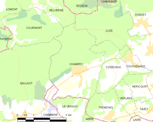
Champey
- commune in Haute-Saône, France
Hiking in Champey
Hiking in Champey, also known as Champasak, is a wonderful experience, particularly for those looking to explore the natural beauty and cultural heritage of southern Laos. Here are some key points to consider:...
- Country:
- Postal Code: 70400
- Coordinates: 47° 35' 5" N, 6° 40' 50" E
- GPS tracks (wikiloc): [Link]
- Area: 11.3 sq km
- Population: 874

Chavanne
- commune in Haute-Saône, France
Hiking in Chavanne
Chavanne, located in the Swiss Alps, is a beautiful destination for hiking enthusiasts. The area is known for its stunning natural scenery, diverse trails, and breathtaking panoramic views. Here are some key points to consider if you're planning a hiking trip to Chavanne:...
- Country:
- Postal Code: 70400
- Coordinates: 47° 33' 28" N, 6° 39' 29" E
- GPS tracks (wikiloc): [Link]
- AboveSeaLevel: 420 м m
- Area: 2.32 sq km
- Population: 234


Villers-sur-Saulnot
- commune in Haute-Saône, France
Hiking in Villers-sur-Saulnot
Villers-sur-Saulnot is a charming commune located in the Haute-Saône department in the Bourgogne-Franche-Comté region of eastern France. It offers a peaceful environment ideal for hiking enthusiasts. Here are some highlights regarding hiking in and around Villers-sur-Saulnot:...
- Country:
- Postal Code: 70400
- Coordinates: 47° 32' 58" N, 6° 38' 50" E
- GPS tracks (wikiloc): [Link]
- Area: 2.37 sq km
- Population: 136


Faymont
- commune in Haute-Saône, France
- Country:
- Postal Code: 70200
- Coordinates: 47° 36' 34" N, 6° 35' 39" E
- GPS tracks (wikiloc): [Link]
- Area: 7.99 sq km
- Population: 261