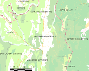
canton of La Chapelle-en-Vercors (canton de La Chapelle-en-Vercors)
- canton of France (until March 2015)
 Hiking in canton of La Chapelle-en-Vercors
Canton de La Chapelle-en-Vercors is a stunning area located in the Vercors Regional Natural Park in the Auvergne-Rhône-Alpes region of France. Known for its rugged limestone cliffs, lush forests, and diverse flora and fauna, it offers numerous hiking opportunities for all skill levels. Here’s an overview of what you can expect when hiking in this beautiful region:
Hiking Trails
-
Le Pas de la Ville: This hike takes you through breathtaking landscapes and offers incredible views of the Vercors Mountains. The trail can be challenging in places but rewards hikers with stunning vistas.
-
Les Gorges de la Bourne: A more accessible trail that runs along the Bourne River, offering hike-goers a chance to enjoy the natural beauty of the gorges and surrounding vegetation.
-
Grand Veymont: For those seeking a more strenuous adventure, the hike to Grand Veymont, the highest peak in the Vercors, provides a rewarding experience with panoramic views from the summit.
-
La Chapelle-en-Vercors to Villard-de-Lans: A scenic route that connects these two charming villages, allowing hikers to explore the local culture while enjoying the countryside.
Difficulty Levels
- Beginner: Many easy trails are suitable for families and novices, often well-marked and not too steep.
- Intermediate: Moderate-level trails are available for those with some hiking experience, with a combination of uphill and downhill sections.
- Advanced: For seasoned hikers, there are rugged paths and steep ascents that can be quite challenging.
Seasonal Considerations
- Spring and Summer: Ideal seasons for hiking, with blooming wildflowers and clear views. Make sure to carry plenty of water and sunscreen.
- Autumn: Offers stunning fall foliage, making for picturesque hikes.
- Winter: Some trails may become snowy or icy, requiring appropriate equipment such as crampons or snowshoes for safety.
Wildlife and Nature
The Vercors region is rich in biodiversity. Keep an eye out for various species of birds, deer, and perhaps even chamois. The area is also known for its unique rock formations and plant life, so a good camera and field guide might come in handy!
Practical Tips
- Maps and Guides: Having a good map or hiking guide for the region is essential, as some trails may not be well marked.
- Weather Check: Always check the weather forecast before heading out, as conditions can change rapidly in mountainous areas.
- Local Resources: Consider visiting the local tourist office for information on trails, guided hikes, and safety tips.
Overall, hiking in Canton de La Chapelle-en-Vercors promises a blend of breathtaking scenery, diverse ecosystems, and rewarding outdoor experiences. Whether you're a seasoned hiker or a weekend adventurer, this region has something to offer everyone. Enjoy your hike!
- Country:

- Capital: La Chapelle-en-Vercors
- Coordinates: 44° 58' 27" N, 5° 25' 18" E


- GPS tracks (wikiloc): [Link]
- Wikidata storage: Wikidata: Q1229907
- INSEE canton code: [2605]
Includes regions:


Saint-Julien-en-Vercors
- commune in Drôme, France
Hiking in Saint-Julien-en-Vercors
Saint-Julien-en-Vercors is a beautiful destination in the Vercors Massif of the French Alps, known for its stunning scenery, rich biodiversity, and a variety of hiking trails suitable for all levels. Here are some highlights of hiking in this area:...
- Country:
- Postal Code: 26420
- Coordinates: 45° 3' 1" N, 5° 26' 58" E
- GPS tracks (wikiloc): [Link]
- Area: 18.47 sq km
- Population: 246


Vassieux-en-Vercors
- commune in Drôme, France
Hiking in Vassieux-en-Vercors
Vassieux-en-Vercors is a beautiful village located in the Vercors Regional Natural Park in France, known for its stunning natural landscapes and outdoor activities, especially hiking. The area is characterized by its dramatic limestone cliffs, dense forests, and rich biodiversity, making it an ideal destination for hikers of all levels....
- Country:
- Postal Code: 26420
- Coordinates: 44° 53' 43" N, 5° 22' 13" E
- GPS tracks (wikiloc): [Link]
- Area: 48.25 sq km
- Population: 318
- Web site: [Link]

Saint-Martin-en-Vercors
- commune in Drôme, France
Hiking in Saint-Martin-en-Vercors
Saint-Martin-en-Vercors is a charming village located in the Vercors Regional Natural Park in the Auvergne-Rhône-Alpes region of France. The area is renowned for its stunning natural landscapes, ranging from limestone plateaus to dense forests, making it an excellent destination for hiking enthusiasts....
- Country:
- Postal Code: 26420
- Coordinates: 45° 1' 22" N, 5° 26' 35" E
- GPS tracks (wikiloc): [Link]
- Area: 27.13 sq km
- Population: 388
Saint-Agnan-en-Vercors
- commune in Drôme, France
Hiking in Saint-Agnan-en-Vercors
Saint-Agnan-en-Vercors is a charming village located in the Vercors Massif, part of the French Pre-Alps. This area is known for its stunning landscapes, rich biodiversity, and extensive network of hiking trails, making it a fantastic destination for both novice and experienced hikers....
- Country:
- Postal Code: 26420
- Coordinates: 44° 56' 8" N, 5° 25' 52" E
- GPS tracks (wikiloc): [Link]
- Area: 84.21 sq km
- Population: 397


La Chapelle-en-Vercors
- commune in Drôme, France
Hiking in La Chapelle-en-Vercors
La Chapelle-en-Vercors is a beautiful village located in the Vercors Regional Natural Park in the Auvergne-Rhône-Alpes region of France. This area is renowned for its stunning landscapes, diverse flora and fauna, and a variety of hiking trails suitable for different skill levels. Here’s what you can expect from hiking in this area:...
- Country:
- Postal Code: 26420
- Coordinates: 44° 58' 4" N, 5° 24' 59" E
- GPS tracks (wikiloc): [Link]
- Area: 45.27 sq km
- Population: 685