
Die (Die)

- commune in Drôme, France
 Hiking in Die
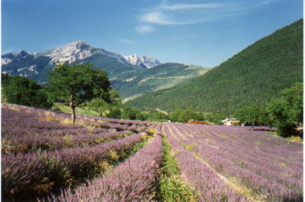
Die, located in the Drôme department of the Auvergne-Rhône-Alpes region in southeastern France, is a fantastic destination for hiking enthusiasts. This charming town is nestled in the Vercors Massif, surrounded by stunning mountainous landscapes, vineyards, and the richly diverse flora and fauna of the region.
Hiking Opportunities
-
The Vercors Regional Natural Park: Just nearby, this park offers numerous trails catering to different skill levels. The park is known for its rugged cliffs, deep gorges, and excellent panoramic views.
-
Famous Trails:
- Pas de la Bergère: A moderate hike offering fantastic views and an encounter with local wildlife. The trail leads you through forests and past beautiful rock formations.
- Le Col de Rousset: A more challenging hike that rewards your efforts with breathtaking vistas of the surrounding valleys and mountains.
- Les Gorges de la Borne: A picturesque and easier trail that wanders through these stunning gorges, providing a serene hiking experience.
-
Wine and Scenic Walks: Die is famous for its Clairette de Die wine. Many trails in the area pass through vineyards, allowing hikers to enjoy the beautiful scenery while getting a glimpse of local viticulture.
Practical Information
-
Best Time to Visit: Spring (April to June) and Fall (September to October) are ideal for hiking, with mild temperatures and fewer crowds. Summer can be hot, but early morning hikes are still enjoyable.
-
Trail Markings: Trails are generally well-marked with yellow and red signs, but it’s advisable to carry a map or a GPS device for guidance.
-
Local Resources: The Die tourism office can provide maps, up-to-date trail conditions, and additional information about guided hikes or local events.
-
Accommodation: There are various options available in Die, from hotels and guesthouses to camping sites for those who prefer a more rugged experience.
Safety Tips
- Always inform someone about your hiking plans and estimated return time.
- Carry plenty of water and snacks, as well as a first-aid kit.
- Dress in layers to accommodate changing weather conditions and wear sturdy hiking boots.
With its rich history, stunning landscapes, and diverse hiking trails, Die is a wonderful destination for both novice and experienced hikers looking to explore the beauty of the French Alps. Happy hiking!
- Country:

- Postal Code: 26150
- Coordinates: 44° 45' 13" N, 5° 22' 13" E


- GPS tracks (wikiloc): [Link]
- Area: 57.28 sq km
- Population: 4576
- Web site: http://www.mairie-die.fr/
- Wikipedia en: wiki(en)
- Wikipedia: wiki(fr)
- Wikidata storage: Wikidata: Q209773
- Wikipedia Commons Category: [Link]
- Freebase ID: [/m/04c19g]
- GeoNames ID: Alt: [3021435]
- SIREN number: [212601132]
- BnF ID: [15252974r]
- VIAF ID: Alt: [146595395]
- GND ID: Alt: [5194543-5]
- Library of Congress authority ID: Alt: [n81136713]
- MusicBrainz area ID: [020dd950-3ad1-4d9d-b733-62bbf96c07fc]
- Twitter username: Alt: [VilledeDie]
- Digital Atlas of the Roman Empire ID: [190]
- INSEE municipality code: 26113
Shares border with regions:


Molières-Glandaz
- former commune in Drôme, France
Hiking in Molières-Glandaz
Molières-Glandaz is a beautiful area nestled in the Auvergne-Rhône-Alpes region of France, known for its stunning landscapes, diverse flora and fauna, and picturesque hiking trails. Here are some highlights and tips for hiking in the Molières-Glandaz area:...
- Country:
- Postal Code: 26150
- Coordinates: 44° 43' 34" N, 5° 23' 57" E
- GPS tracks (wikiloc): [Link]
- Area: 2.87 sq km
- Population: 104


Laval-d'Aix
- commune in Drôme, France
Hiking in Laval-d'Aix
Laval-d'Aix, located in the Auvergne-Rhône-Alpes region of France, offers stunning scenic beauty and a variety of hiking opportunities. Here are some key points to consider:...
- Country:
- Postal Code: 26150
- Coordinates: 44° 42' 48" N, 5° 25' 53" E
- GPS tracks (wikiloc): [Link]
- Area: 20.05 sq km
- Population: 124


Romeyer
- commune in Drôme, France
Hiking in Romeyer
Romeyer is a beautiful area in the French Alps, often praised for its stunning natural beauty, diverse landscapes, and excellent hiking opportunities. While it may not be as widely known as some other hiking destinations in France, it offers a great experience for those looking to explore the outdoors....
- Country:
- Postal Code: 26150
- Coordinates: 44° 46' 46" N, 5° 24' 32" E
- GPS tracks (wikiloc): [Link]
- Area: 41.46 sq km
- Population: 203
Barsac
- commune in Drôme, France
Hiking in Barsac
Barsac, located in the Drôme department in the Auvergne-Rhône-Alpes region of France, offers a range of beautiful hiking opportunities. This area is characterized by its stunning natural landscapes, including rolling hills, rocky outcrops, and forests, making it an excellent destination for hikers of all skill levels....
- Country:
- Postal Code: 26150
- Coordinates: 44° 43' 51" N, 5° 17' 28" E
- GPS tracks (wikiloc): [Link]
- Area: 15.58 sq km
- Population: 144
Ponet-et-Saint-Auban
- commune in Drôme, France
Hiking in Ponet-et-Saint-Auban
Ponet-et-Saint-Auban, located in the Drôme department of southeastern France, offers a beautiful landscape perfect for hiking enthusiasts. The area is characterized by its diverse terrain, ranging from rolling hills and dense forests to rocky outcrops, providing plenty of opportunities for exploration and adventure....
- Country:
- Postal Code: 26150
- Coordinates: 44° 47' 14" N, 5° 18' 59" E
- GPS tracks (wikiloc): [Link]
- Area: 13.21 sq km
- Population: 127
Marignac-en-Diois
- commune in Drôme, France
Hiking in Marignac-en-Diois
Marignac-en-Diois is a picturesque village located in the Drôme department of southeastern France, nestled in the heart of the Diois region. This area is known for its stunning natural landscapes, making it an excellent destination for hiking enthusiasts....
- Country:
- Postal Code: 26150
- Coordinates: 44° 48' 9" N, 5° 20' 1" E
- GPS tracks (wikiloc): [Link]
- Area: 18.26 sq km
- Population: 204

Chamaloc
- commune in Drôme, France
Hiking in Chamaloc
Chamaloc, located in the Île-de-France region of France, is a lesser-known destination for hiking enthusiasts. While it may not be as famous as other hiking hotspots in France, it offers beautifully scenic trails and a peaceful escape into nature. Here’s what you need to know about hiking in and around Chamaloc:...
- Country:
- Postal Code: 26150
- Coordinates: 44° 47' 55" N, 5° 23' 2" E
- GPS tracks (wikiloc): [Link]
- Area: 21.89 sq km
- Population: 129