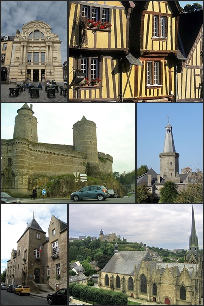
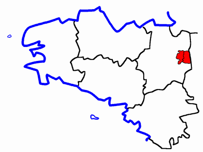
arrondissement of Fougères-Vitré (arrondissement de Fougères-Vitré)

- arrondissement of France
- Country:

- Capital: Fougères
- Coordinates: 48° 25' 0" N, 1° 20' 0" E


- GPS tracks (wikiloc): [Link]
- Area: 2152 sq km
- Population: 183508
- Wikipedia en: wiki(en)
- Wikipedia: wiki(fr)
- Wikidata storage: Wikidata: Q701222
- Freebase ID: [/m/095fm_]
- GeoNames ID: Alt: [3017608]
- INSEE arrondissement code: [351]
Includes regions:

canton of Argentré-du-Plessis
- canton of France (until March 2015)
- Country:
- Capital: Argentré-du-Plessis
- Coordinates: 48° 1' 45" N, 1° 10' 11" E
- GPS tracks (wikiloc): [Link]

canton of Saint-Brice-en-Coglès
- former canton of France
- Country:
- Capital: Saint-Brice-en-Coglès
- Coordinates: 48° 24' 3" N, 1° 20' 33" E
- GPS tracks (wikiloc): [Link]


canton of Antrain
- canton of France
- Country:
- Capital: Antrain
- Coordinates: 48° 25' 10" N, 1° 31' 27" E
- GPS tracks (wikiloc): [Link]
- Area: 557.1 sq km
- Population: 36618

canton of La Guerche-de-Bretagne
- canton of France
- Country:
- Capital: La Guerche-de-Bretagne
- Coordinates: 47° 56' 32" N, 1° 13' 43" E
- GPS tracks (wikiloc): [Link]
- Area: 664.42 sq km
- Population: 41317


canton of Châteaubourg
- canton of France (until March 2015)
- Country:
- Capital: Châteaubourg
- Coordinates: 48° 5' 1" N, 1° 23' 0" E
- GPS tracks (wikiloc): [Link]

canton of Louvigné-du-Désert
- canton of France (until March 2015)
- Country:
- Capital: Louvigné-du-Désert
- Coordinates: 48° 28' 56" N, 1° 12' 5" E
- GPS tracks (wikiloc): [Link]

canton of Saint-Aubin-du-Cormier
- canton of France (until March 2015)
- Country:
- Capital: Saint-Aubin-du-Cormier
- Coordinates: 48° 17' 46" N, 1° 22' 48" E
- GPS tracks (wikiloc): [Link]