Auriol (Auriol)

- commune in Bouches-du-Rhône, France
 Hiking in Auriol
Auriol, located in the Bouches-du-Rhône department in the Provence-Alpes-Côte d'Azur region of southern France, offers a variety of scenic hiking opportunities. Nestled between the Sainte-Baume mountains and the Calanques National Park, Auriol provides a beautiful backdrop with diverse landscapes, from hills and forests to rugged cliffs and Mediterranean flora.
Hiking Trails
-
Chemin de la Rose: This trail is relatively easy and takes you through the charming countryside, showcasing the local flora and providing lovely views of the surrounding hills.
-
Cascades de la Sainte-Baume: A popular hike that leads you to picturesque waterfalls. The path offers a moderate challenge and rewards hikers with breathtaking sights and the sounds of cascading water.
-
Les Crêtes de Ceyreste: For those looking for a more challenging experience, this route offers stunning panoramic views of the coastline and the nearby mountain ranges.
-
Sentier des Baumes: This trail takes you through forest areas and offers an impressive view of the Sainte-Baume massif, making it an ideal hike for nature lovers and photography enthusiasts.
Tips for Hiking in Auriol
-
Weather: The climate in Auriol can be quite hot during the summer months, so it's essential to wear appropriate clothing, bring plenty of water, and start your hikes early in the day.
-
Navigation: While many trails are well-marked, having a detailed map or a GPS device can be useful, especially for the more intricate routes.
-
Wildlife: Keep an eye out for local wildlife, including various bird species, small mammals, and unique flora. Remember to respect the environment and stick to designated trails.
-
Safety: Always inform someone of your hiking plans and check for any local guidelines or trail conditions before setting out.
Local Amenities
Auriol has a charming village atmosphere, with options for dining and local accommodations. It can serve as a good base for exploring the surrounding natural beauty, so consider taking time to enjoy the local culture and cuisine.
In summary, hiking in Auriol provides a wonderful blend of natural beauty, diverse trails, and cultural experiences. Whether you're a beginner or an experienced hiker, there's something for everyone in this picturesque region.
- Country:

- Postal Code: 13390
- Coordinates: 43° 22' 10" N, 5° 37' 53" E


- GPS tracks (wikiloc): [Link]
- Area: 44.64 sq km
- Population: 11538
- Web site: http://www.mairie-auriol.fr
- Wikipedia en: wiki(en)
- Wikipedia: wiki(fr)
- Wikidata storage: Wikidata: Q330442
- Wikipedia Commons Category: [Link]
- Freebase ID: [/m/08zlcx]
- Freebase ID: [/m/08zlcx]
- GeoNames ID: Alt: [6452139]
- GeoNames ID: Alt: [6452139]
- SIREN number: [211300074]
- SIREN number: [211300074]
- BnF ID: [15247289v]
- BnF ID: [15247289v]
- VIAF ID: Alt: [163265608]
- VIAF ID: Alt: [163265608]
- PACTOLS thesaurus ID: [pcrtMPptrPy60f]
- PACTOLS thesaurus ID: [pcrtMPptrPy60f]
- Digital Atlas of the Roman Empire ID: [17876]
- Digital Atlas of the Roman Empire ID: [17876]
- INSEE municipality code: 13007
- INSEE municipality code: 13007
Shares border with regions:

Plan-d'Aups-Sainte-Baume
- commune in Var, France
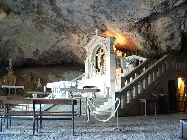
Hiking in Plan-d'Aups-Sainte-Baume
Plan-d'Aups-Sainte-Baume is a beautiful destination for hiking enthusiasts, located in the Var department of the Provence-Alpes-Côte d'Azur region of southeastern France. Nestled at the foot of the Sainte-Baume mountain range, this area offers a range of trails that vary in difficulty and scenery....
- Country:
- Postal Code: 83640
- Coordinates: 43° 19' 48" N, 5° 43' 3" E
- GPS tracks (wikiloc): [Link]
- AboveSeaLevel: 700 м m
- Area: 24.91 sq km
- Population: 2067


Gémenos
- commune in Bouches-du-Rhône, France
- Country:
- Postal Code: 13420
- Coordinates: 43° 17' 46" N, 5° 37' 37" E
- GPS tracks (wikiloc): [Link]
- Area: 32.75 sq km
- Population: 6387
- Web site: [Link]

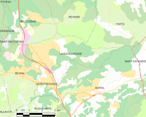
La Bouilladisse
- commune in Bouches-du-Rhône, France
Hiking in La Bouilladisse
La Bouilladisse is a charming commune located in the Bouches-du-Rhône department in southeastern France, nestled in the picturesque region of Provence. It offers a variety of hiking opportunities, characterized by beautiful landscapes, scenic views, and a mild Mediterranean climate....
- Country:
- Postal Code: 13720
- Coordinates: 43° 23' 43" N, 5° 35' 43" E
- GPS tracks (wikiloc): [Link]
- Area: 12.61 sq km
- Population: 6079
- Web site: [Link]


La Destrousse
- commune in Bouches-du-Rhône, France
Hiking in La Destrousse
La Destrousse is a charming village located in the Provence-Alpes-Côte d'Azur region of France. Nestled in the foothills of the Sainte-Baume mountains, it serves as a great starting point for various hiking opportunities in the surrounding area....
- Country:
- Postal Code: 13112
- Coordinates: 43° 22' 35" N, 5° 36' 24" E
- GPS tracks (wikiloc): [Link]
- Area: 2.93 sq km
- Population: 3381
- Web site: [Link]

Trets
- commune in Bouches-du-Rhône, France
Hiking in Trets
Trets is a charming town located in the Provence-Alpes-Côte d'Azur region of France, and it offers access to some beautiful hiking opportunities. The surrounding landscape features rolling hills, vineyards, and stunning views of the Sainte-Victoire Mountain, making it an appealing destination for outdoor enthusiasts....
- Country:
- Postal Code: 13530
- Coordinates: 43° 26' 49" N, 5° 41' 9" E
- GPS tracks (wikiloc): [Link]
- Area: 70.31 sq km
- Population: 10963
- Web site: [Link]

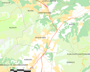
Roquevaire
- commune in Bouches-du-Rhône, France
Hiking in Roquevaire
Roquevaire is a charming commune located in the Provence-Alpes-Côte d'Azur region of France, known for its beautiful landscapes and rich natural environment. Here are some highlights and tips for hiking in Roquevaire:...
- Country:
- Postal Code: 13360
- Coordinates: 43° 20' 58" N, 5° 36' 17" E
- GPS tracks (wikiloc): [Link]
- AboveSeaLevel: 160 м m
- Area: 23.83 sq km
- Population: 8939
- Web site: [Link]


Saint-Zacharie
- commune in Var, France
Hiking in Saint-Zacharie
Saint-Zacharie is a charming commune located in the Provence-Alpes-Côte d'Azur region of France, nestled in the foothills of the Sainte-Baume mountain range. The area offers a range of hiking opportunities that cater to various skill levels and preferences, making it an excellent destination for outdoor enthusiasts....
- Country:
- Postal Code: 83640
- Coordinates: 43° 23' 3" N, 5° 42' 24" E
- GPS tracks (wikiloc): [Link]
- Area: 27.02 sq km
- Population: 5392