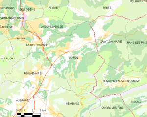
La Bouilladisse (La Bouilladisse)

- commune in Bouches-du-Rhône, France
 Hiking in La Bouilladisse
La Bouilladisse is a charming commune located in the Bouches-du-Rhône department in southeastern France, nestled in the picturesque region of Provence. It offers a variety of hiking opportunities, characterized by beautiful landscapes, scenic views, and a mild Mediterranean climate.
Popular Hiking Trails:
-
Sentier des Faysses:
- This trail takes you through the local forest areas and offers trails that are accessible for both beginners and experienced hikers. The route includes views of the surrounding hills and valleys.
-
Colline de Roquevaire:
- A slightly challenging hike that rewards with stunning panoramas. The ascent can be steep in some areas, but the views from the top are worth the effort.
-
Les Gorges du Regalon:
- A bit further afield, but within reach of La Bouilladisse, this dramatic gorge features rocky cliffs and flowing waters. The trails vary in difficulty and offer a mix of terrain.
Tips for Hiking in La Bouilladisse:
-
Best Time to Visit: The ideal months for hiking are spring (April to June) and early autumn (September to October) when the weather is pleasant and the landscape is lush.
-
Preparation: Always wear appropriate footwear and bring plenty of water, especially during the summer months. Some trails can become quite warm.
-
Wildlife and Nature: Keep an eye out for local flora and fauna; the region is home to many species of birds and indigenous plants.
-
Respect Nature: Remember to follow Leave No Trace principles to keep the trails and surroundings clean. Stay on marked paths to protect the natural environment.
-
Local Amenities: La Bouilladisse has basic amenities, but for a full day in the outdoors, consider bringing your own snacks or meals.
Hiking in La Bouilladisse combines the charm of the Provençal countryside with the thrill of outdoor adventure. Whether you’re looking for a leisurely stroll or a more challenging hike, this area has something to offer for every outdoor enthusiast.
- Country:

- Postal Code: 13720
- Coordinates: 43° 23' 43" N, 5° 35' 43" E


- GPS tracks (wikiloc): [Link]
- Area: 12.61 sq km
- Population: 6079
- Web site: http://www.ville-bouilladisse.com
- Wikipedia en: wiki(en)
- Wikipedia: wiki(fr)
- Wikidata storage: Wikidata: Q384208
- Wikipedia Commons Category: [Link]
- Freebase ID: [/m/0282k50]
- Freebase ID: [/m/0282k50]
- GeoNames ID: Alt: [6456717]
- GeoNames ID: Alt: [6456717]
- SIREN number: [211300165]
- SIREN number: [211300165]
- BnF ID: [15247298t]
- BnF ID: [15247298t]
- INSEE municipality code: 13016
- INSEE municipality code: 13016
Shares border with regions:

Auriol
- commune in Bouches-du-Rhône, France
Hiking in Auriol
Auriol, located in the Bouches-du-Rhône department in the Provence-Alpes-Côte d'Azur region of southern France, offers a variety of scenic hiking opportunities. Nestled between the Sainte-Baume mountains and the Calanques National Park, Auriol provides a beautiful backdrop with diverse landscapes, from hills and forests to rugged cliffs and Mediterranean flora....
- Country:
- Postal Code: 13390
- Coordinates: 43° 22' 10" N, 5° 37' 53" E
- GPS tracks (wikiloc): [Link]
- Area: 44.64 sq km
- Population: 11538
- Web site: [Link]


Belcodène
- commune in Bouches-du-Rhône, France
Hiking in Belcodène
Belcodène is a charming commune located in the Bouches-du-Rhône department in southern France, near the Sainte-Baume mountain range. The natural scenery around Belcodène offers a wonderful setting for hiking enthusiasts, combining picturesque landscapes with diverse flora and fauna....
- Country:
- Postal Code: 13720
- Coordinates: 43° 25' 35" N, 5° 35' 21" E
- GPS tracks (wikiloc): [Link]
- Area: 12.97 sq km
- Population: 1906
- Web site: [Link]


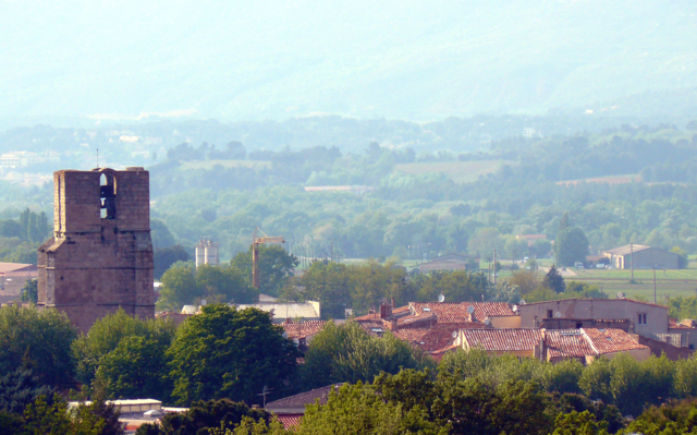
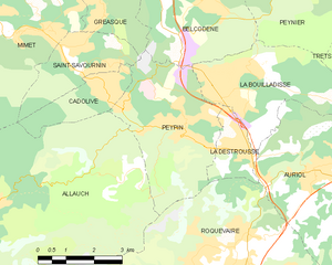
La Destrousse
- commune in Bouches-du-Rhône, France
Hiking in La Destrousse
La Destrousse is a charming village located in the Provence-Alpes-Côte d'Azur region of France. Nestled in the foothills of the Sainte-Baume mountains, it serves as a great starting point for various hiking opportunities in the surrounding area....
- Country:
- Postal Code: 13112
- Coordinates: 43° 22' 35" N, 5° 36' 24" E
- GPS tracks (wikiloc): [Link]
- Area: 2.93 sq km
- Population: 3381
- Web site: [Link]

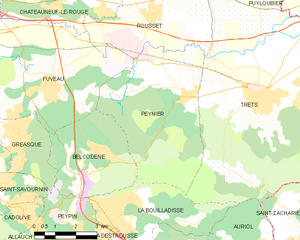
Peynier
- commune in Bouches-du-Rhône, France
Hiking in Peynier
Peynier is a charming village located in the Provence-Alpes-Côte d'Azur region of France. It's surrounded by beautiful landscapes, making it an excellent spot for hiking enthusiasts. Here are some highlights and tips for hiking in and around Peynier:...
- Country:
- Postal Code: 13790
- Coordinates: 43° 26' 49" N, 5° 38' 29" E
- GPS tracks (wikiloc): [Link]
- Area: 24.76 sq km
- Population: 3368
- Web site: [Link]

Trets
- commune in Bouches-du-Rhône, France
Hiking in Trets
Trets is a charming town located in the Provence-Alpes-Côte d'Azur region of France, and it offers access to some beautiful hiking opportunities. The surrounding landscape features rolling hills, vineyards, and stunning views of the Sainte-Victoire Mountain, making it an appealing destination for outdoor enthusiasts....
- Country:
- Postal Code: 13530
- Coordinates: 43° 26' 49" N, 5° 41' 9" E
- GPS tracks (wikiloc): [Link]
- Area: 70.31 sq km
- Population: 10963
- Web site: [Link]

Peypin
- commune in Bouches-du-Rhône, France
Hiking in Peypin
Peypin is a charming commune located in the Bouches-du-Rhône department in the Provence-Alpes-Côte d'Azur region of France. It offers beautiful landscapes and a variety of hiking opportunities, making it a great destination for outdoor enthusiasts....
- Country:
- Postal Code: 13124
- Coordinates: 43° 23' 9" N, 5° 34' 42" E
- GPS tracks (wikiloc): [Link]
- Area: 13.35 sq km
- Population: 5454
- Web site: [Link]