Aymavilles (Aymavilles)
- Italian comune
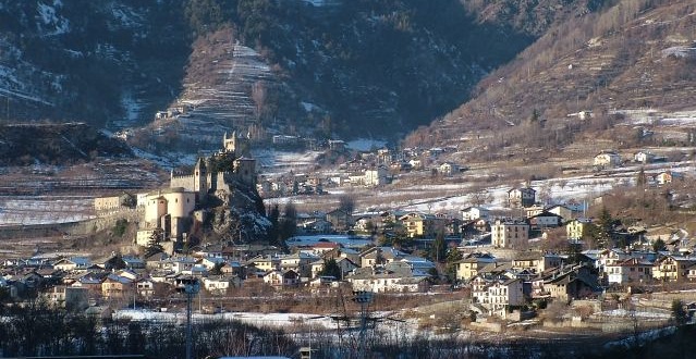
Aymavilles is a picturesque village located in the Aosta Valley region of Italy, known for its stunning Alpine scenery and rich cultural heritage. Hiking in Aymavilles offers a mix of challenging trails, beautiful landscapes, and opportunities to experience the local flora and fauna.
Popular Hiking Trails:
-
Circuit of Aymavilles:
- A moderate loop trail that takes you through the surrounding forests and offers panoramic views of the Mont Blanc massif and the Gran Paradiso.
- Distance: Approximately 10-12 km.
- Duration: 3-5 hours depending on your pace.
-
Col de Aymavilles:
- A steeper trail leading to the Col de Aymavilles, providing breathtaking views of the Aosta Valley and the surrounding peaks.
- Distance: About 8 km round trip.
- Duration: 4-6 hours.
-
Trail to the Castle of Aymavilles:
- A shorter, more accessible trail that leads to the historical Castle of Aymavilles.
- Distance: Less than 2 km.
- Duration: 1 hour, great for a leisurely hike.
Tips for Hiking in Aymavilles:
- Preparation: Always check the weather conditions before heading out as the mountain weather can change rapidly.
- Equipment: Wear good hiking boots and bring trekking poles if needed. A map or GPS device can be very helpful.
- Water and Snacks: Carry plenty of water and some snacks, as there may not be facilities along all trails.
- Respect Nature: Follow Leave No Trace principles to preserve the natural beauty of the area.
- Local Insights: Take the opportunity to learn about the local flora, fauna, and culture from residents or through guided tours.
Conclusion:
Hiking in Aymavilles can be a delightful experience, combining natural beauty with cultural heritage. Whether you're an experienced hiker or a beginner, there are options for everyone. Make sure to take your time to enjoy the stunning vistas and the tranquility of the Alps. Happy hiking!
- Country:

- Postal Code: 11010
- Local Dialing Code: 0165
- Licence Plate Code: AO
- Coordinates: 45° 42' 4" N, 7° 14' 25" E


- GPS tracks (wikiloc): [Link]
- AboveSeaLevel: 640 м m
- Area: 53.24 sq km
- Population: 2065
- Web site: http://www.comune.aymavilles.ao.it
- Wikipedia en: wiki(en)
- Wikipedia: wiki(it)
- Wikidata storage: Wikidata: Q34791
- Wikipedia Commons Category: [Link]
- Wikipedia Commons Maps Category: [Link]
- Freebase ID: [/m/0fs_18]
- GeoNames ID: Alt: [6537027]
- VIAF ID: Alt: [236108489]
- OSM relation ID: [45629]
- WOEID: [710470]
- UN/LOCODE: [ITAYM]
- ISTAT ID: 007008
- Italian cadastre code: A108
Shares border with regions:


Cogne
- town and comune in Italy
Cogne is a stunning valley located in the Aosta region of northern Italy, surrounded by the majestic Grand Paradiso National Park. It offers a variety of hiking opportunities that cater to different skill levels and preferences, from leisurely walks to challenging treks....
- Country:

- Postal Code: 11012
- Local Dialing Code: 0165
- Licence Plate Code: AO
- Coordinates: 45° 36' 27" N, 7° 21' 29" E


- GPS tracks (wikiloc): [Link]
- AboveSeaLevel: 1534 м m
- Area: 213.04 sq km
- Population: 1370
- Web site: [Link]


Gressan
- town and comune in Aosta Valley, Italy
Gressan is a beautiful municipality in the Aosta Valley region of Italy. Located near the town of Aosta, it's an excellent destination for hiking enthusiasts, offering a variety of trails suitable for different skill levels. Here are some highlights about hiking in Gressan:...
- Country:

- Postal Code: 11020
- Local Dialing Code: 0165
- Licence Plate Code: AO
- Coordinates: 45° 43' 0" N, 7° 17' 0" E


- GPS tracks (wikiloc): [Link]
- AboveSeaLevel: 626 м m
- Area: 25.3 sq km
- Population: 3378
- Web site: [Link]


Jovençan
- Italian comune
Jovençan is a picturesque municipality located in the Aosta Valley region of Italy, nestled in the Alps. It's a great destination for hiking enthusiasts, offering a range of trails that cater to various skill levels. Here are some highlights about hiking in Jovençan:...
- Country:

- Postal Code: 11020
- Local Dialing Code: 0165
- Licence Plate Code: AO
- Coordinates: 45° 42' 56" N, 7° 16' 25" E


- GPS tracks (wikiloc): [Link]
- AboveSeaLevel: 632 м m
- Area: 7 sq km
- Population: 736
- Web site: [Link]


Saint-Pierre
- comune in Aosta Valley, Italy
Saint-Pierre, located in the Aosta Valley region of Italy, is a fantastic destination for hiking enthusiasts. The area is known for its stunning mountain scenery, rich history, and diverse trails that cater to a variety of skill levels. Here are some key points about hiking in this picturesque region:...
- Country:

- Postal Code: 11010
- Local Dialing Code: 0165
- Licence Plate Code: AO
- Coordinates: 45° 42' 36" N, 7° 13' 34" E


- GPS tracks (wikiloc): [Link]
- AboveSeaLevel: 731 м m
- Area: 26.18 sq km
- Population: 3213
- Web site: [Link]


Sarre, Aosta Valley
- Italian comune
Hiking in Sarre, located in the Aosta Valley of northern Italy, offers a fantastic outdoor experience surrounded by stunning mountain scenery. The Aosta Valley is known for its breathtaking landscapes, rich history, and numerous hiking trails suitable for all levels of experience....
- Country:

- Postal Code: 11010
- Local Dialing Code: 0165
- Licence Plate Code: AO
- Coordinates: 45° 43' 4" N, 7° 15' 27" E


- GPS tracks (wikiloc): [Link]
- AboveSeaLevel: 631 м m
- Area: 28.28 sq km
- Population: 4878
- Web site: [Link]


Valsavarenche
- Italian comune
Valsavarenche is a picturesque valley located in the Aosta Valley region of the Italian Alps, and it is part of the Gran Paradiso National Park. This area is known for its stunning natural beauty, diverse wildlife, and well-maintained trails, making it an excellent destination for hiking enthusiasts....
- Country:

- Postal Code: 11010
- Local Dialing Code: 0165
- Licence Plate Code: AO
- Coordinates: 45° 35' 32" N, 7° 12' 28" E


- GPS tracks (wikiloc): [Link]
- AboveSeaLevel: 1541 м m
- Area: 138.21 sq km
- Population: 164
- Web site: [Link]


Villeneuve, Aosta Valley
- Italian comune
 Hiking in Villeneuve, Aosta Valley
Villeneuve, located in the Aosta Valley of northwestern Italy, is a charming village surrounded by stunning alpine scenery. The area is notable for its outdoor adventure opportunities, particularly hiking....
- Country:

- Postal Code: 11018
- Local Dialing Code: 0165
- Licence Plate Code: AO
- Coordinates: 45° 42' 9" N, 7° 12' 27" E


- GPS tracks (wikiloc): [Link]
- AboveSeaLevel: 670 м m
- Area: 8.8 sq km
- Population: 1236
- Web site: [Link]
