
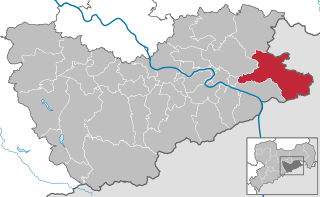
Bad Schandau (Bad Schandau)

- town in Germany
 Hiking in Bad Schandau
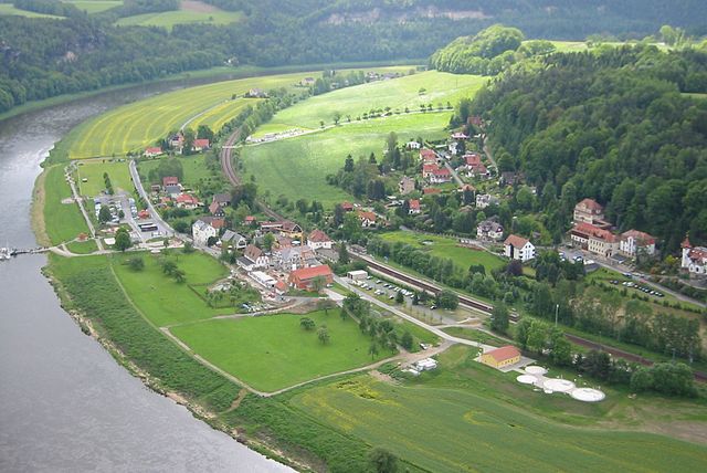
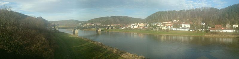
Bad Schandau, located in the Saxon Switzerland National Park in Germany, is a splendid destination for hiking enthusiasts. Known for its stunning sandstone formations, lush forests, and picturesque landscapes along the Elbe River, it offers a variety of trails for all skill levels. Here are some highlights:
Hiking Trails
-
Malerweg (Painter's Way):
- This is one of the most famous long-distance hiking trails in Germany, spanning about 112 kilometers (70 miles) through the Saxon Switzerland region. The trail is named after the artists of the Romantic period who were inspired by the dramatic scenery. It offers both challenging sections and easier paths and can be done in stages.
-
Schrammsteine:
- A popular and challenging hike, this trail leads to the Schrammsteine rock formations. It features stunning views from the top and involves some climbing, making it suitable for experienced hikers.
-
Kirnitzschtal:
- This is a more moderate trail along the scenic Kirnitzschtal stream, offering beautiful views and a chance to see waterfalls and rock formations. It’s a great choice for families or those looking for a less strenuous hike.
-
Bastei Bridge:
- A short hike from the parking area leads to the iconic Bastei Bridge, which offers breathtaking panoramas of the Elbe River and the surrounding cliffs. This is a must-see for anyone visiting Bad Schandau.
Tips for Hiking in Bad Schandau:
- Plan Ahead: Check trail conditions and weather forecasts. Some trails can become slippery after rain.
- Wear Appropriate Gear: Good hiking shoes are essential due to rocky and uneven terrain. Layers are ideal since weather can change quickly.
- Stay Hydrated: Bring enough water, especially for longer hikes. There are limited facilities on some trails.
- Wildlife and Nature: Keep an eye out for diverse flora and fauna. The area is known for its biodiversity.
Other Activities
- Explore the Town: Bad Schandau is known for its charming town center, thermal baths, and spa facilities.
- Water Activities: The Elbe River provides opportunities for kayaking and sailing, allowing for a different perspective of the stunning cliffs.
Getting There
Bad Schandau is easily reachable by public transportation from Dresden and other cities. The scenic train ride along the Elbe is particularly enjoyable.
Overall, Bad Schandau offers a unique blend of natural beauty and outdoor activities, making it a fantastic destination for hiking and outdoor adventures.
- Country:

- Postal Code: 01812–01814
- Local Dialing Code: 035022
- Licence Plate Code: PIR
- Coordinates: 50° 55' 0" N, 14° 9' 0" E


- GPS tracks (wikiloc): [Link]
- AboveSeaLevel: 146 м m
- Area: 46.77 sq km
- Population: 3606
- Web site: http://www.bad-schandau.de/
- Wikipedia en: wiki(en)
- Wikipedia: wiki(de)
- Wikidata storage: Wikidata: Q6406
- Wikipedia Commons Gallery: [Link]
- Wikipedia Commons Category: [Link]
- Freebase ID: [/m/04nl5m]
- Freebase ID: [/m/04nl5m]
- GeoNames ID: Alt: [2953352]
- GeoNames ID: Alt: [2953352]
- VIAF ID: Alt: [130292195]
- VIAF ID: Alt: [130292195]
- OSM relation ID: [534534]
- OSM relation ID: [534534]
- GND ID: Alt: [4105800-8]
- GND ID: Alt: [4105800-8]
- archINFORM location ID: [11770]
- archINFORM location ID: [11770]
- Library of Congress authority ID: Alt: [n88158465]
- Library of Congress authority ID: Alt: [n88158465]
- MusicBrainz area ID: [a362e392-39fb-4123-9db3-43dbdddd2a63]
- MusicBrainz area ID: [a362e392-39fb-4123-9db3-43dbdddd2a63]
- WOEID: [636502]
- WOEID: [636502]
- Historical Gazetteer (GOV) ID: [SCHDAUJO70BW]
- Historical Gazetteer (GOV) ID: [SCHDAUJO70BW]
- Facebook Places ID: [106128389419027]
- Facebook Places ID: [106128389419027]
- NKCR AUT ID: [ge947726]
- NKCR AUT ID: [ge947726]
- National Library of Israel ID: [001020544]
- National Library of Israel ID: [001020544]
- German municipality key: 14628030
- German municipality key: 14628030
Includes regions:
Ostrau
Hiking in Ostrau
Ostrau, part of the municipality of Bad Schandau in the Saxon Switzerland region of Germany, is a fantastic destination for hiking enthusiasts. The surrounding area is known for its stunning sandstone formations, lush forests, and beautiful views, making it a popular spot for both novice and experienced hikers....
- Country:
- Postal Code: 01814
- Local Dialing Code: 035022
- AboveSeaLevel: 245 м m
Waltersdorf
Hiking in Waltersdorf
Waltersdorf, located near Bad Schandau in the Saxon Switzerland region of Germany, is a beautiful destination for hiking enthusiasts. This area is known for its stunning sandstone formations, dense forests, and unique geological features, making it one of the most picturesque hiking regions in the country....
- Country:
- Postal Code: 01814
- Local Dialing Code: 035022
- Coordinates: 50° 57' 0" N, 14° 6' 23" E
- GPS tracks (wikiloc): [Link]

Krippen
- village in Germany
Hiking in Krippen
Krippen is a picturesque village located in the Saxon Switzerland region of Germany, known for its stunning rock formations, deep valleys, and lush forests. It’s an excellent base for hiking enthusiasts looking to explore the natural beauty of the Elbe Sandstone Mountains....
- Country:
- Postal Code: 01814
- Local Dialing Code: 035022
- Coordinates: 50° 54' 28" N, 14° 9' 58" E
- GPS tracks (wikiloc): [Link]
- AboveSeaLevel: 133 м m
Prossen
- village in Germany
Hiking in Prossen
Prossen is a charming village located in the state of Saxony, Germany, and is known for its picturesque landscapes and access to various hiking trails. Nestled near the Elbe River and surrounded by natural beauty, it serves as a great base for outdoor enthusiasts....
- Country:
- Coordinates: 50° 55' 48" N, 14° 6' 57" E
- GPS tracks (wikiloc): [Link]

Schmilka
- village in Germany
Hiking in Schmilka
Schmilka is a picturesque village located in Saxony, Germany, near the border with the Czech Republic. It's situated on the Elbe River and lies at the edge of the beautiful Saxon Switzerland National Park, which is a popular destination for hikers and outdoor enthusiasts....
- Country:
- Coordinates: 50° 53' 30" N, 14° 13' 52" E
- GPS tracks (wikiloc): [Link]
Postelwitz
- human settlement in Germany
Hiking in Postelwitz
Postelwitz is a small village located in the beautiful region of Saxon Switzerland in Germany. This area is renowned for its stunning sandstone formations, dense forests, and picturesque valleys, making it a fantastic destination for hiking enthusiasts. Here are some details about hiking in and around Postelwitz:...
- Country:
- Postal Code: 01814
- Local Dialing Code: 035022
- AboveSeaLevel: 230 м m
Porschdorf
- village in Germany
Hiking in Porschdorf
Porschdorf is a picturesque village located in the Saxon Switzerland region of Germany, known for its stunning natural landscapes and hiking opportunities. Nestled near the Elbe River and surrounded by striking sandstone formations, Porschdorf serves as a great base for exploring the area's rich hiking trails....
- Country:
- Postal Code: 01814
- Local Dialing Code: 035022
- Coordinates: 50° 56' 30" N, 14° 7' 37" E
- GPS tracks (wikiloc): [Link]
- AboveSeaLevel: 195 м m
- Area: 10.93 sq km
- Web site: [Link]
Shares border with regions:

Sebnitz
- town in the Sächsische Schweiz-Osterzgebirge district, in the Free State of Saxony, Germany
Hiking in Sebnitz
Sebnitz, a charming town located in Saxony, Germany, is renowned for its beautiful scenery and picturesque hiking opportunities, particularly within the nearby Saxon Switzerland National Park. Here are some highlights and tips for hiking in and around Sebnitz:...
- Country:
- Postal Code: 01851–01855
- Local Dialing Code: 035971
- Coordinates: 50° 58' 0" N, 14° 17' 0" E
- GPS tracks (wikiloc): [Link]
- AboveSeaLevel: 379 м m
- Area: 88.23 sq km
- Population: 9571
- Web site: [Link]


Gohrisch
- municipality in the Sächsische Schweiz-Osterzgebirge district, in Saxony, Germany
Hiking in Gohrisch
Gohrisch is a beautiful area located in the Saxon Switzerland region of Germany, known for its stunning sandstone rock formations, lush forests, and breathtaking landscapes. This region is a part of the Saxon Switzerland National Park, which is a popular destination for hiking enthusiasts....
- Country:
- Postal Code: 01824
- Local Dialing Code: 035021
- Licence Plate Code: PIR
- Coordinates: 50° 54' 35" N, 14° 6' 29" E
- GPS tracks (wikiloc): [Link]
- AboveSeaLevel: 300 м m
- Area: 34.86 sq km
- Population: 1862
- Web site: [Link]


Hohnstein
- town in the Sächsische Schweiz-Osterzgebirge district, in the Free State of Saxony, Germany
Hiking in Hohnstein
Hohnstein is a charming town located in Saxon Switzerland, Germany, an area known for its stunning natural landscapes, unique rock formations, and excellent hiking opportunities. Here are some highlights and tips for hiking in and around Hohnstein:...
- Country:
- Postal Code: 01848
- Local Dialing Code: 035975
- Licence Plate Code: PIR
- Coordinates: 50° 59' 0" N, 14° 7' 0" E
- GPS tracks (wikiloc): [Link]
- AboveSeaLevel: 330 м m
- Area: 64.61 sq km
- Population: 3301
- Web site: [Link]


Königstein
- town in the Free State of Saxony in Germany
Hiking in Königstein
Königstein, located in the Saxon Switzerland region of Germany, is renowned for its stunning natural landscapes, rich history, and excellent hiking opportunities. Here are some key highlights regarding hiking in and around Königstein:...
- Country:
- Postal Code: 01824
- Local Dialing Code: 035021
- Licence Plate Code: PIR
- Coordinates: 50° 55' 8" N, 14° 4' 17" E
- GPS tracks (wikiloc): [Link]
- AboveSeaLevel: 212 м m
- Area: 26.93 sq km
- Population: 2098
- Web site: [Link]

Rathen
- village in Saxony, Germany
Hiking in Rathen
Rathen is a picturesque village located in the Saxon Switzerland region of Germany, which is renowned for its stunning landscapes, rock formations, and hiking trails. If you're considering hiking in Rathen, here are some essentials and highlights to keep in mind:...
- Country:
- Postal Code: 01824
- Local Dialing Code: 035024
- Licence Plate Code: PIR
- Coordinates: 50° 57' 0" N, 14° 5' 0" E
- GPS tracks (wikiloc): [Link]
- AboveSeaLevel: 112 м m
- Area: 3.58 sq km
- Population: 348
- Web site: [Link]

Rathmannsdorf
- municipality in the Saxon district of Sächsische Schweiz-Osterzgebirge, Saxony, Germany
Hiking in Rathmannsdorf
Rathmannsdorf is a charming village located in Germany, particularly known for its picturesque landscapes and proximity to stunning natural areas, making it a great destination for hiking enthusiasts. Here’s what you should know about hiking in Rathmannsdorf:...
- Country:
- Postal Code: 01814
- Local Dialing Code: 035022
- Licence Plate Code: PIR
- Coordinates: 50° 56' 0" N, 14° 8' 0" E
- GPS tracks (wikiloc): [Link]
- AboveSeaLevel: 225 м m
- Area: 4.37 sq km
- Population: 915
- Web site: [Link]


Reinhardtsdorf-Schöna
- municipality in the Sächsische Schweiz-Osterzgebirge, Saxony, Germany
Hiking in Reinhardtsdorf-Schöna
Reinhardtsdorf-Schöna is a beautiful area located near the border of Germany and the Czech Republic, in the Saxon Switzerland National Park. This region is renowned for its picturesque landscapes, rocky formations, and hiking opportunities. Here are some highlights and tips for hiking in Reinhardtsdorf-Schöna:...
- Country:
- Postal Code: 01814
- Local Dialing Code: 035028
- Licence Plate Code: PIR
- Coordinates: 50° 54' 0" N, 14° 12' 0" E
- GPS tracks (wikiloc): [Link]
- AboveSeaLevel: 281 м m
- Area: 31.76 sq km
- Population: 1329
- Web site: [Link]