Bagneux (Bagneux)

- commune in Indre, France
- Country:

- Postal Code: 36210
- Coordinates: 47° 10' 59" N, 1° 45' 11" E


- GPS tracks (wikiloc): [Link]
- Area: 25.3 sq km
- Population: 175
- Wikipedia en: wiki(en)
- Wikipedia: wiki(fr)
- Wikidata storage: Wikidata: Q1071860
- Wikipedia Commons Category: [Link]
- Freebase ID: [/m/03nv90x]
- GeoNames ID: Alt: [6448571]
- SIREN number: [213600117]
- BnF ID: [15257315s]
- INSEE municipality code: 36011
Shares border with regions:


Anjouin
- commune in Indre, France
- Country:
- Postal Code: 36210
- Coordinates: 47° 11' 22" N, 1° 48' 4" E
- GPS tracks (wikiloc): [Link]
- Area: 28.91 sq km
- Population: 335


Buxeuil
- commune in Indre, France
- Country:
- Postal Code: 36150
- Coordinates: 47° 7' 59" N, 1° 41' 12" E
- GPS tracks (wikiloc): [Link]
- Area: 19.75 sq km
- Population: 222
- Web site: [Link]
Saint-Christophe-en-Bazelle
- commune in Indre, France
- Country:
- Postal Code: 36210
- Coordinates: 47° 11' 31" N, 1° 42' 42" E
- GPS tracks (wikiloc): [Link]
- Area: 13.94 sq km
- Population: 400
Orville
- commune in Indre, France
- Country:
- Postal Code: 36210
- Coordinates: 47° 9' 8" N, 1° 47' 28" E
- GPS tracks (wikiloc): [Link]
- Area: 9.35 sq km
- Population: 136


Dun-le-Poëlier
- commune in Indre, France
- Country:
- Postal Code: 36210
- Coordinates: 47° 12' 14" N, 1° 45' 13" E
- GPS tracks (wikiloc): [Link]
- Area: 22.56 sq km
- Population: 447
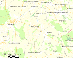
Poulaines
- commune in Indre, France
- Country:
- Postal Code: 36210
- Coordinates: 47° 9' 7" N, 1° 39' 48" E
- GPS tracks (wikiloc): [Link]
- Area: 46.32 sq km
- Population: 895