Beausemblant (Beausemblant)

- commune in Drôme, France
- Country:

- Postal Code: 26240
- Coordinates: 45° 13' 1" N, 4° 49' 49" E


- GPS tracks (wikiloc): [Link]
- Area: 11.67 sq km
- Population: 1416
- Wikipedia en: wiki(en)
- Wikipedia: wiki(fr)
- Wikidata storage: Wikidata: Q782427
- Wikipedia Commons Category: [Link]
- Freebase ID: [/m/03mgl85]
- GeoNames ID: Alt: [6447885]
- SIREN number: [212600415]
- BnF ID: [15252902w]
- PACTOLS thesaurus ID: [pcrt2U9I9wbtuM]
- INSEE municipality code: 26041
Shares border with regions:


Saint-Uze
- commune in Drôme, France
 Hiking in Saint-Uze
Saint-Uze is a charming village located in the Auvergne-Rhône-Alpes region of France. While it may not be one of the most famous hiking destinations, it does offer opportunities for hiking and enjoying the surrounding natural beauty....
- Country:
- Postal Code: 26240
- Coordinates: 45° 11' 3" N, 4° 51' 40" E
- GPS tracks (wikiloc): [Link]
- Area: 10.1 sq km
- Population: 2025
- Web site: [Link]

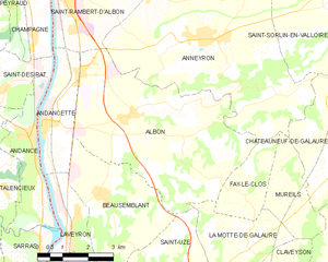
Albon
- commune in Drôme, France
- Country:
- Postal Code: 26140
- Coordinates: 45° 14' 44" N, 4° 50' 56" E
- GPS tracks (wikiloc): [Link]
- Area: 25.62 sq km
- Population: 1879


Andancette
- commune in Drôme, France
- Country:
- Postal Code: 26140
- Coordinates: 45° 14' 31" N, 4° 48' 25" E
- GPS tracks (wikiloc): [Link]
- Area: 5.98 sq km
- Population: 1344
- Web site: [Link]

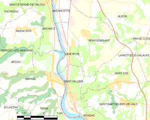
Laveyron
- commune in Drôme, France
- Country:
- Postal Code: 26240
- Coordinates: 45° 12' 0" N, 4° 48' 44" E
- GPS tracks (wikiloc): [Link]
- Area: 5.32 sq km
- Population: 1145