Saint-Uze (Saint-Uze)

- commune in Drôme, France
 Hiking in Saint-Uze
Saint-Uze is a charming village located in the Auvergne-Rhône-Alpes region of France. While it may not be one of the most famous hiking destinations, it does offer opportunities for hiking and enjoying the surrounding natural beauty.
Hiking Trails
-
Local Paths: The area around Saint-Uze boasts a network of local trails that wind through picturesque countryside, rolling hills, and woodlands. These paths are often less crowded and allow for a more intimate experience with nature.
-
Vercors Regional Natural Park: A short drive from Saint-Uze, the Vercors Massif offers more challenging hikes. The park features dramatic cliffs, deep gorges, and rich biodiversity. This area is ideal for both novice and experienced hikers looking for a day trip.
-
Isère Valley: The nearby Isère Valley provides additional scenic trails, including routes that take you along rivers and through valleys.
Points of Interest
- Breathtaking Views: Many trails in the region offer stunning panoramic views of the surrounding mountains and countryside, especially during sunrise or sunset.
- Flora and Fauna: The area is home to diverse plant and animal life, making it a great spot for nature enthusiasts and photographers.
Hiking Tips
- Local Maps: Always carry a detailed map of the trails. Local tourist offices often provide free maps and information on current trail conditions.
- Weather Preparedness: Weather can change quickly in the region, so dress in layers and check the forecast before heading out.
- Stay Hydrated and Nourished: Bring enough water and snacks, especially if you plan to hike longer distances.
Accessibility
- Saint-Uze is generally accessible by car, and it can serve as a convenient base for exploring other nearby hiking trails in the region.
While hiking in Saint-Uze may not provide high-altitude challenges, it offers beautiful scenery and the charm of rural France, making it a delightful destination for a more laid-back hiking experience. Always respect nature, stay on marked trails, and enjoy your outdoor adventure!
- Country:

- Postal Code: 26240
- Coordinates: 45° 11' 3" N, 4° 51' 40" E


- GPS tracks (wikiloc): [Link]
- Area: 10.1 sq km
- Population: 2025
- Web site: http://www.saintuze.fr/
- Wikipedia en: wiki(en)
- Wikipedia: wiki(fr)
- Wikidata storage: Wikidata: Q219383
- Wikipedia Commons Category: [Link]
- Freebase ID: [/m/03mhl3h]
- GeoNames ID: Alt: [6430239]
- SIREN number: [212603328]
- BnF ID: [15253192q]
- VIAF ID: Alt: [316740018]
- PACTOLS thesaurus ID: [pcrtbnTOM4isvX]
- TGN ID: [1035542]
- INSEE municipality code: 26332
Shares border with regions:


La Motte-de-Galaure
- commune in Drôme, France
Hiking in La Motte-de-Galaure
La Motte-de-Galaure is a charming village located in the Drôme department in the Auvergne-Rhône-Alpes region of southeastern France. This area is characterized by its rolling hills, vineyards, and stunning countryside, making it a great location for hiking enthusiasts....
- Country:
- Postal Code: 26240
- Coordinates: 45° 11' 48" N, 4° 54' 20" E
- GPS tracks (wikiloc): [Link]
- Area: 7.73 sq km
- Population: 786

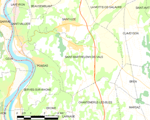
Saint-Barthélemy-de-Vals
- commune in Drôme, France
Hiking in Saint-Barthélemy-de-Vals
Saint-Barthélemy-de-Vals is a charming village located in the Auvergne-Rhône-Alpes region of France, known for its beautiful landscapes, rolling hills, and diverse natural scenery. While it may not be as famous as some hiking destinations, it offers a variety of trails suited to different skill levels, making it a lovely spot for outdoor enthusiasts....
- Country:
- Postal Code: 26240
- Coordinates: 45° 10' 9" N, 4° 52' 19" E
- GPS tracks (wikiloc): [Link]
- Area: 20.27 sq km
- Population: 1873

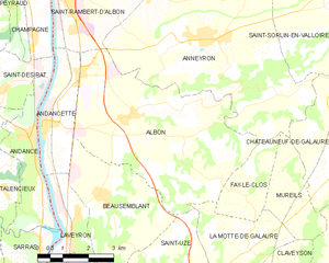
Albon
- commune in Drôme, France
- Country:
- Postal Code: 26140
- Coordinates: 45° 14' 44" N, 4° 50' 56" E
- GPS tracks (wikiloc): [Link]
- Area: 25.62 sq km
- Population: 1879


Beausemblant
- commune in Drôme, France
- Country:
- Postal Code: 26240
- Coordinates: 45° 13' 1" N, 4° 49' 49" E
- GPS tracks (wikiloc): [Link]
- Area: 11.67 sq km
- Population: 1416

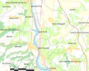
Laveyron
- commune in Drôme, France
- Country:
- Postal Code: 26240
- Coordinates: 45° 12' 0" N, 4° 48' 44" E
- GPS tracks (wikiloc): [Link]
- Area: 5.32 sq km
- Population: 1145